eVidyarthi
Menu
  • School
    • Close
    • CBSE English Medium
    • CBSE Hindi Medium
    • UP Board
    • Bihar Board
    • Maharashtra Board
    • MP Board
    • Close
  • English
    • Close
    • English Grammar for School
    • Basic English Grammar
    • Basic English Speaking
    • English Vocabulary
    • English Idioms & Phrases
    • Personality Enhancement
    • Interview Skills
    • Close
  • Sarkari Exam Preparation
    • Close
    • All Govt Exams Preparation
    • State Wise Competitive Exam Preparation
    • India – Notes for All Competitive Exams
    • MCQs & Notes for Competitive Exams
    • NCERT Syllabus for Competitive Exam
    • Close
  • Study Abroad
    • Close
    • Study in Australia
    • Study in Canada
    • Study in UK
    • Study in Germany
    • Study in USA
    • Close
  • Current Affairs
    • Close
    • Current Affairs
    • Current Affairs Quizzes
    • State Wise Current Affairs
    • Monthly Current Affairs
    • Close
Geography Class 11 Maharashtra Board | Menu
  • MCQ Geography Class 11 Maharashtra Board
  • Questions Answers Geography Class 11 Maharashtra Board
  • Notes Geography Class 11 Maharashtra Board
  • Important Questions Geography Class 11 Maharashtra Board
  • Book Geography Class 11 Maharashtra Board
  • Geography Class 11

Important Questions Class 11 Chapter 9 Geography Maharashtra Board

Disaster Management

Short Questions

1. What is a disaster?

Answer: A disaster is the impact of a hazard on human populations causing death, injury, or property loss.

2. What is a hazard?

Answer: A hazard is a natural or man-made phenomenon that poses a threat to people or assets.

3. What is vulnerability in disaster management?

Answer: Vulnerability is the condition that makes people or regions susceptible to disasters.

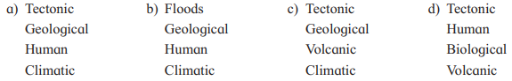
4. Name a tectonic disaster.

Answer: Earthquake is a tectonic disaster.

5. What is an example of a geological disaster?

Answer: Landslide is a geological disaster.

6. Give an example of a meteorological disaster.

Answer: Cyclone is a meteorological disaster.

7. What is a man-made disaster example?

Answer: Bhopal gas tragedy (1984) is a man-made disaster.

8. What is the primary effect of a disaster?

Answer: Primary effects are direct consequences like building collapse during an earthquake.

9. What is a secondary effect of a disaster?

Answer: Secondary effects are consequences triggered by primary effects, like fires after an earthquake.

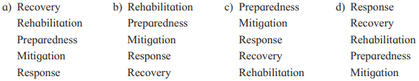
10. What is disaster preparedness?

Answer: Disaster preparedness involves measures to reduce disaster effects, like awareness campaigns.

11. What is mitigation in disaster management?

Answer: Mitigation refers to actions taken to minimize disaster impacts before they occur.

12. Name one structural mitigation measure.

Answer: Constructing river embankments is a structural mitigation measure.

13. What is a non-structural mitigation measure?

Answer: Public education on disasters is a non-structural mitigation measure.

14. Which Indian agency oversees disaster management?

Answer: The National Disaster Management Authority (NDMA) oversees disaster management in India.

15. How does remote sensing help in disaster management?

Answer: Remote sensing maps disaster-prone areas and monitors events like cyclones.

Long Questions

1. Explain the difference between a hazard and a disaster with an example.

Answer: A hazard is a potential threat, like an earthquake occurring in an uninhabited area, while a disaster is the impact of a hazard on human populations, causing damage. For example, an earthquake in the Sahara Desert is a hazard, but the 2005 India-Pakistan earthquake, killing 80,000, was a disaster. This distinction highlights that disasters depend on human vulnerability and exposure.

2. What are tectonic disasters, and provide an example from the chapter?

Answer: Tectonic disasters are caused by movements in the Earth’s crust, such as earthquakes, tsunamis, or volcanic eruptions. An example is the 2004 Indian Ocean tsunami, which killed 2,50,000 people across India, Indonesia, and Sri Lanka. These disasters are often unpredictable but can be mitigated through preparedness.

3. Describe the role of vulnerability in disaster impact with an example.

Answer: Vulnerability refers to conditions like geography or socio-economic factors that make people susceptible to disasters. For instance, coastal populations in Odisha are more vulnerable to cyclones, as seen in the 1999 cyclone (10,000 deaths). Reducing vulnerability through preparedness lowers disaster impacts.

4. How does the capacity to cope reduce disaster impact? Give an example.

Answer: Capacity to cope is the ability to manage disasters using skills and resources, reducing vulnerability. For example, improved early warning systems and evacuations during Cyclone Fani (2019) resulted in only 89 deaths compared to 10,000 in the 1999 Odisha cyclone. This shows how better coping mechanisms save lives.

5. What are the primary effects of disasters? Illustrate with an example.

Answer: Primary effects are the direct consequences of a disaster, such as death or infrastructure damage. For example, during the 2005 Mumbai flash floods, 1,100 people died due to flooding. These immediate impacts highlight the destructive power of disasters.

6. Explain the role of remote sensing in disaster management with an example.

Answer: Remote sensing uses satellite data to map disaster-prone areas and monitor events, aiding preparedness and response. For instance, during Cyclone Fani (2019), satellites tracked its path, enabling timely evacuations in Odisha. This technology enhances disaster management efficiency.

7. What is the disaster management cycle, and why is it called a cycle?

Answer: The disaster management cycle includes preparedness, mitigation, response, recovery, and rehabilitation, addressing disasters before and after they occur. It is called a cycle because these phases are interconnected and continuous, ensuring ongoing improvement in disaster resilience. For example, lessons from Cyclone Fani (2019) improved future preparedness.

8. How does India’s disaster management framework function post-2004 tsunami?

Answer: Post-2004 tsunami, India established the NDMA, NIDM, and SDMAs to coordinate disaster management. The Ministry of Home Affairs oversees operations, with nodal ministries like Agriculture for droughts. This structured framework improved responses, as seen in Cyclone Fani’s low death toll.

9. What are structural and non-structural mitigation measures? Provide examples.

Answer: Structural measures involve physical constructions like river embankments to reduce disaster impacts, while non-structural measures include policies or education, such as public awareness campaigns. For example, retrofitting buildings (structural) and disaster training (non-structural) were key in reducing Cyclone Fani’s impact. These measures work together to enhance safety.

10. Why did the 2019 Cyclone Fani cause fewer deaths than the 1999 Odisha cyclone?

Answer: Cyclone Fani (2019) caused only 89 deaths compared to 10,000 in the 1999 Odisha cyclone due to improved early warning systems using satellites. Timely evacuations and cyclone shelters ensured safety, reflecting enhanced preparedness. India’s disaster management advancements significantly reduced vulnerability and losses.

Notes Class 11 Chapter 9 Geography Maharashtra Board

Disaster Management

Introduction

Disasters, whether natural or man-made, cause significant loss of life, property, and economic stability. Disaster management is a multidisciplinary process aimed at reducing the impact of disasters through preparedness, mitigation, response, recovery, and rehabilitation. This chapter explores the types, causes, effects, and management strategies for disasters, with a focus on India’s disaster management framework.


Major Disasters Across the World

The following table summarizes key disasters, their locations, and impacts:

YearDisasterLocationNo. of Deaths/Losses (Approx.)
1920EarthquakeChina2,35,000
1923EarthquakeJapan1,42,000
1970Bhola CycloneIndia & Bangladesh5,00,000
1984Methyl Isocyanate Gas LeakBhopal, India10,000; 5.5 lakh affected
1985Ruiz Volcanic EruptionColombia25,000
1994LandslideVarandha Ghat, Maharashtra, India20; 1 km of Konkan Coast road damaged
1995Rail AccidentFirozabad, India400
1999CycloneOdisha, India10,000
2004TsunamiIndia, Indonesia, Sri Lanka2,50,000
2005EarthquakeIndia & Pakistan80,000
2005Flash FloodsMumbai, India1,100
2014HailstormMaharashtra, India97; 2,700 farm animals dead, crops affected
2019Cyclone FaniOdisha, India89

Key Concepts

1. Classification of Disasters

Disasters are classified based on their origin:

  • Tectonic Disasters: Caused by movements in the Earth’s crust.
    • Examples: Earthquakes (e.g., 2005 India-Pakistan earthquake), tsunamis (e.g., 2004 Indian Ocean tsunami), volcanic eruptions.
  • Geological Disasters: Result from geological processes.
    • Examples: Landslides (e.g., 1994 Varandha Ghat), mudslides (e.g., 2014 Malin mudslide), avalanches.
  • Meteorological Disasters: Driven by weather conditions.
    • Examples: Cyclones (e.g., 1999 Odisha cyclone), floods (e.g., 2005 Mumbai floods), storms, heatwaves.
  • Biological Disasters: Caused by living organisms.
    • Examples: Epidemics (e.g., 1992 Surat plague), locust attacks, pest attacks.
  • Anthropogenic (Man-made) Disasters: Result from human activities or negligence.
    • Examples: Industrial accidents (e.g., 1984 Bhopal gas tragedy), transportation accidents (e.g., 1995 Firozabad rail accident), nuclear accidents.

2. Hazard vs. Disaster

  • Hazard: A natural or man-made phenomenon that poses a threat to people, structures, or economic assets (e.g., high rainfall, earthquakes). It may or may not cause harm unless it impacts human populations.
  • Disaster: The result of a hazard affecting human populations, causing death, injury, property loss, or economic disruption. A disaster occurs when society cannot cope with the hazard’s impact.
    • Example: An earthquake in the Sahara Desert (uninhabited) is a hazard, but an earthquake in Assam (populated) is a disaster.

3. Vulnerability

  • Vulnerability refers to the conditions that make people or regions susceptible to disasters. These include:
    • Geographical Factors: Coastal areas are vulnerable to cyclones, seismically active areas to earthquakes.
    • Socio-economic Factors: Poverty, dense populations, and inadequate infrastructure increase vulnerability.
    • Demographic Factors: Children, the elderly, and marginalized groups are more vulnerable.
  • Reducing vulnerability involves improving preparedness and coping capacity.

4. Capacity to Cope

  • The ability of individuals, organizations, and systems to manage disasters using available skills perspective skills and resources.
  • Improved coping capacity reduces vulnerability and disaster impact.
  • Example: The 1999 Odisha cyclone caused 10,000 deaths, but Cyclone Fani in 2019 caused only 89 deaths due to enhanced preparedness and mitigation.

Effects of Disasters

Disasters have immediate and long-term effects across various sectors:

  1. Primary Effects: Direct consequences of the disaster.
    • Example: Building collapse during the 2005 India-Pakistan earthquake (80,000 deaths), flooding during the 2005 Mumbai floods (1,100 deaths).
  2. Secondary Effects: Consequences triggered by primary effects.
    • Example: Fires ignited by earthquakes, disruption of power and water services after the 2004 tsunami.
  3. Tertiary Effects: Long-term impacts.
    • Example: Loss of homes, altered river channels, and reduced tourism after the 2004 Indian Ocean tsunami (2,50,000 deaths).
  4. Other Losses: Economic losses (e.g., crop and livestock damage in the 2014 Maharashtra hailstorm), social disruption, and psychological trauma.

Disaster Management Cycle

Disaster management is a cyclical process involving pre-disaster and post-disaster phases (see Fig. 9.1 in the textbook):

1. Pre-disaster Phase

  • Disaster Preparedness: Measures to prepare for and reduce disaster effects.
    • Examples: Awareness campaigns, mock drills, strengthening weak structures, preparing emergency kits (food, water, medicines).
    • Community-level actions: Training residents to escape fires, planning evacuation routes in flood-prone areas.
  • Mitigation: Actions to minimize disaster impact before occurrence.
    • Structural Measures: Construction of river embankments, retrofitting buildings.
    • Non-structural Measures: Public education, disaster training, regulating land use.
    • Example: Satellite-based early warnings for Cyclone Fani (2019) enabled timely evacuations, reducing deaths.
  • Prevention: Avoiding disasters, especially man-made ones, through safety regulations and careful planning.
    • Example: Preventing industrial accidents like the Bhopal gas tragedy (1984) through stricter safety protocols.

2. Post-disaster Phase

  • Disaster Response: Immediate actions after a disaster to meet victims’ needs.
    • Examples: Providing food, shelter, and medical aid, conducting search and rescue operations.
    • Focus: Ensuring safety and minimizing suffering until further measures are implemented.
  • Recovery: Restoring normalcy in affected areas.
    • Examples: Repairing roads and bridges, restoring electricity and water services, clearing debris, providing financial aid.
    • Example: Post-2005 Mumbai floods, recovery involved rebuilding infrastructure and supporting displaced families.
  • Rehabilitation: Long-term efforts to restore normalcy.
    • Examples: Rebuilding homes, supporting livelihoods (e.g., providing seeds to farmers), relocating vulnerable communities.
    • Example: Post-2004 tsunami, rehabilitation included reconstructing coastal villages and supporting fisheries.

Structural vs. Non-structural Measures

  • Structural Measures: Physical constructions to reduce hazard impacts.
    • Examples: River embankments, disaster-resistant buildings, flood drains.
  • Non-structural Measures: Knowledge-based or policy-driven actions.
    • Examples: Public awareness campaigns, disaster training, land-use regulations.

Examples of Measures (Pre/Post-disaster, Structural/Non-structural):

MeasurePre/Post-disasterStructural/Non-structuralApplicable Disaster
Conducting mock drillsPre-disasterNon-structuralEarthquake, landslide, fire
Discussions on disaster risksPre-disasterNon-structuralAll disasters
Using art to portray disaster impactsPre-disasterNon-structuralAll disasters
Emergency services lecturesPre-disasterNon-structuralAll disasters
Making disaster bookletsPre-disasterNon-structuralAll disasters
Retrofitting old buildingsPre-disasterStructuralEarthquake, cyclone
Constructing sheltersPre-disasterStructuralCyclone, flood
Changing land-use policiesPre-disasterNon-structuralFlood, cyclone
Building disaster-resistant housesPre-disasterStructuralEarthquake, cyclone, flood
Constructing proper drainsPre-disasterStructuralFlood
Plantation activitiesPre-disasterStructuralLandslide, flood
Disaster awareness via mediaPre-disasterNon-structuralAll disasters
Satellite-based early warningsPre-disasterNon-structuralCyclone, flood
Delineating evacuation routesPre-disasterNon-structuralCyclone, flood, earthquake

Role of Technology in Disaster Management

Information Technology (IT), including Remote Sensing, GIS, and GPS, enhances disaster management efficiency:

  • Remote Sensing: Maps disaster-prone areas, monitors cyclones, and assesses flood damage.
    • Example: Microwave data identifies flood-inundated areas; meteorological satellites track cyclones (e.g., Cyclone Fani).
  • GIS (Geographic Information System): Supports planning, communication, and damage assessment.
    • Example: Mapping flood-prone areas for evacuation planning.
  • GPS (Global Positioning System): Provides location-based services for rescue operations.
    • Example: Locating disaster-affected areas in remote regions.
  • Communication Satellites: Establish connectivity in inaccessible areas post-disaster.
  • India Quake App: Developed by the National Centre for Seismology, it provides real-time earthquake data (location, time, magnitude).

Disaster Management in India

India is highly disaster-prone due to its geo-climatic conditions and socio-economic vulnerabilities. Post-2004 tsunami, India revamped its disaster management framework:

  • Institutional Setup:
    • National Disaster Management Authority (NDMA): Established at the central level to coordinate disaster management.
    • National Institute of Disaster Management (NIDM): Focuses on training and research.
    • State Disaster Management Authorities (SDMAs): Operate at state and district levels.
    • National Crisis Management Committee: Functions under the Ministry of Home Affairs (nodal ministry for disaster management).
    • Nodal ministries: Ministry of Agriculture for droughts, Ministry of Earth Sciences for earthquakes, etc.
  • Role of Agencies:
    • Military and Paramilitary Forces: Assist in rescue, relief, and rehabilitation (e.g., Home Guards).
    • ISRO and NRSC: Provide satellite data for cyclone tracking and damage assessment.
  • Policy Changes: Post-2004 tsunami, states were mandated to set up disaster management offices, improving preparedness and response.

Questions Answers Class 11 Chapter 9 Geography Maharashtra Board

Disaster Management – Solutions

Q. 1) Choose the correct alternative :

1) Which of the following groups shows the correct type of disasters?

Answer:

abcd
TectonicFloodTectonicTectonic
GeologicalGeologicalGeologicalHuman
HumanHumanVolcanicBiological
ClimateClimateClimateVolcanic

2) The Meteorological Department has given information that a cyclone is likely to make a landfall at Odisha in 2 days. Which of the following group shows the correct sequence of management processes?

Answer:

abcd
RecoveryRehabilitationPreparednessResponse
RehabilitationPreparednessMitigationRecovery
PreparednessMitigationResponseRehabilitation
MitigationResponseRecoveryPreparedness
ResponseRecoveryRehabilitationMitigation

3) Statement A – The cyclonic depression originating in the Bay of Bengal is marching towards Tamil Nadu at a velocity of 350 km/ hr.

Statement B – The loss of life was not much but property loss occurred on a large scale.

i) A indicates a disaster and B indicates a hazard.
ii) A indicates a hazard while B indicates a disaster.
iii) A indicates a disaster but B does not indicate a hazard.
iv) A does not indicate a disaster but B indicates a hazard.

Answer: ii) A indicates a hazard while B indicates a disaster.

  • Explanation: Statement A describes a cyclonic depression, which is a hazard (a potential threat). Statement B describes the impact (property loss), which indicates a disaster (the result of a hazard affecting society).

4) India has been successful in mitigating the effects of the following disaster:
a) earthquake
b) volcanic eruptions
c) floods
d) cyclones

Answer: c) floods


Q. 2) Write notes on :

1) Vulnerability

Answer: Vulnerability refers to the geographical, social, economic, or political conditions that make people or regions susceptible to disasters. For example, coastal populations are more vulnerable to cyclones, while those in seismically active areas are prone to earthquakes. Factors like poverty, age (e.g., children or elderly), and dense populations increase vulnerability. Reducing vulnerability involves improving preparedness and coping capacity.

2) Disaster

Answer: A disaster is the result of a hazard impacting human populations, causing death, injury, property loss, or economic disruption. Unlike a hazard, which is a natural or man-made phenomenon, a disaster occurs when society cannot cope with the hazard’s effects. For instance, an earthquake in an uninhabited area is a hazard, but in a populated area like Assam, it becomes a disaster.

3) Hazard

Answer: A hazard is a natural or man-made phenomenon that poses a threat to people, structures, or economic assets and may lead to a disaster. Examples include high rainfall (potentially causing floods), earthquakes, or industrial accidents. Hazards become disasters when they affect human populations and cause significant damage.

4) Man-made disasters

Answer: Man-made disasters result from human errors, negligence, or intentional actions. Examples include industrial accidents (e.g., Bhopal gas tragedy, 1984, with 10,000 deaths and 5.5 lakh affected), transportation accidents (e.g., Firozabad rail accident, 1995, with 400 deaths), and nuclear accidents. These disasters are often preventable through proper safety measures and regulations.


Q. 3) Write in short:

1) Mitigation for cyclones

Answer: Mitigation for cyclones involves measures to minimize their impact, such as using satellite data for early warnings, evacuating vulnerable areas, constructing cyclone-resistant buildings, and strengthening embankments. For example, effective mitigation during Cyclone Fani (2019) reduced deaths to 89 compared to 10,000 in the 1999 Odisha cyclone.

2) Preparedness for floods

Answer: Flood preparedness includes awareness campaigns, training communities, and preparing emergency kits with food, water, and medicine. Other measures involve strengthening weak structures, planning evacuation routes, and using remote sensing to monitor flood-prone areas, as seen in the management of Kerala floods (2018).

3) Rehabilitation after earthquake

Answer: Rehabilitation after an earthquake focuses on long-term restoration, such as rebuilding homes, roads, and bridges, restoring basic services, and providing financial aid. For example, after the 2005 India-Pakistan earthquake (80,000 deaths), rehabilitation included reconstructing infrastructure and supporting displaced populations to restore normalcy.


Q. 4) Answer in detail:

1) Explain the types of disaster according to origin

Answer: Disasters are classified based on their origin into the following types:

  • Tectonic Disasters: Caused by movements in the Earth’s crust, e.g., earthquakes (2005 India-Pakistan earthquake, 80,000 deaths), tsunamis (2004 Indian Ocean tsunami, 2,50,000 deaths), and volcanic eruptions.
  • Geological Disasters: Result from geological processes, e.g., landslides (1994 Varandha Ghat landslide, 20 deaths) and mudslides (2014 Malin mudslide).
  • Meteorological Disasters: Driven by weather conditions, e.g., cyclones (1999 Odisha cyclone, 10,000 deaths), floods (2005 Mumbai flash floods, 1,100 deaths), and heatwaves.
  • Biological Disasters: Caused by living organisms, e.g., epidemics (1992 Surat plague) and pest attacks.
  • Anthropogenic (Man-made) Disasters: Result from human activities, e.g., industrial accidents (1984 Bhopal gas tragedy, 10,000 deaths), transportation accidents (1995 Firozabad rail accident, 400 deaths), and nuclear accidents.
  • Each type requires specific mitigation and preparedness strategies to reduce impacts.

2) Explain the effects of disasters with the help of examples

Answer: Disasters cause immediate and long-term effects across various sectors:

  • Primary Effects: Direct results of the disaster, e.g., collapse of buildings during the 2005 India-Pakistan earthquake (80,000 deaths) or flooding during the 2005 Mumbai flash floods (1,100 deaths).
  • Secondary Effects: Consequences of primary effects, e.g., fires caused by earthquakes or power and water disruptions after the 2004 tsunami.
  • Tertiary Effects: Long-term impacts, e.g., loss of homes, changes in river channels, or reduced tourism after the 2004 tsunami in India, Indonesia, and Sri Lanka (2,50,000 deaths).
  • Other losses include economic impacts (e.g., crop and livestock losses in the 2014 Maharashtra hailstorm, affecting 2,700 farm animals) and social disruption (e.g., displacement after the 1985 Ruiz volcanic eruption in Colombia, 25,000 deaths).

3) Write about the preparedness in Disaster Management in India

Answer: Disaster preparedness in India involves proactive measures to reduce the impact of disasters:

  • Institutional Framework: Post-2004 tsunami, India established the National Disaster Management Authority (NDMA), National Institute of Disaster Management (NIDM), and State Disaster Management Authorities (SDMAs) to coordinate efforts. The Ministry of Home Affairs oversees disaster management, with nodal ministries like Agriculture for droughts.
  • Technology Use: Remote sensing, GIS, and GPS are used to map disaster-prone areas, monitor cyclones (e.g., Cyclone Fani), and provide early warnings. The India Quake app by the National Centre for Seismology shares real-time earthquake data.
  • Community Preparedness: Awareness campaigns, mock drills (e.g., for earthquakes), and training in flood-prone areas ensure communities are ready. For instance, evacuation plans and cyclone shelters were critical during Cyclone Fani (2019).
  • Structural Measures: Retrofitting buildings and constructing flood embankments enhance resilience.
  • These efforts have improved India’s capacity to cope, as seen in the reduced deaths during Cyclone Fani (89 deaths) compared to the 1999 cyclone (10,000 deaths).

Important Questions Class 11 Chapter 8 Geography Maharashtra Board

Biomes

Short Questions

1. What is a biome?

Answer: A biome is a large area where plants and animals coexist under similar climatic conditions.

2. How does latitude influence vegetation in biomes?

Answer: Vegetation changes from dense, broad-leaved forests near the equator to sparse mosses near the poles.

3. Which biome has the highest biodiversity?

Answer: The tropical rainforest biome has the highest biodiversity.

4. What is the main tree in the tropical deciduous biome?

Answer: Teak is the main tree in the tropical deciduous biome.

5. What is the characteristic grass of the savanna biome?

Answer: Elephant grass is the characteristic grass of the savanna biome.

6. Why do desert biome plants have thorny vegetation?

Answer: Thorny vegetation reduces evaporation and protects against herbivores.

7. What is the Mediterranean biome also known as?

Answer: The Mediterranean biome is also known as Chaparral.

8. Which biome is dominated by coniferous trees?

Answer: The Taiga biome is dominated by coniferous trees.

9. What is permafrost in the tundra biome?

Answer: Permafrost is a permanently frozen layer of soil in the tundra biome.

10. Which biome supports extensive agriculture like wheat and maize?

Answer: The temperate grassland biome supports extensive agriculture.

11. What is the primary occupation in the Taiga biome?

Answer: Lumbering is the primary occupation in the Taiga biome.

12. Which biome is not found in the Southern Hemisphere?

Answer: The Taiga biome is not found in the Southern Hemisphere.

13, What is the main animal in the Himalayan mountain biome?

Answer: The yak is the main animal in the Himalayan mountain biome.

14. What is the top layer of the marine biome called?

Answer: The euphotic layer is the top layer of the marine biome.

15. What is desertification in the context of the tropical desert biome?

Answer: Desertification is the spread of desert areas due to sand transport and human activities.

Long Questions

1. How does climate determine the boundaries of different biomes?

Answer: Climate, including rainfall, temperature, humidity, and insolation, shapes the boundaries of biomes by influencing the types of plants and animals that can survive. For example, tropical rainforests thrive in high rainfall and warm temperatures, while tundras exist in cold, low-rainfall conditions. These climatic factors dictate the adaptations and distribution of species within each biome.

2. Why is the tropical rainforest biome considered the most biodiverse?

Answer: The tropical rainforest biome, located near the equator, has high rainfall, consistent warmth, and abundant sunlight, creating ideal conditions for diverse plant and animal life. It hosts over half of Earth’s species, with dense, multi-layered forests supporting unique niches for species like monkeys, parrots, and insects. However, deforestation and industrialization threaten this biodiversity.

3. Explain the adaptations of vegetation in the tropical desert biome.

Answer: Vegetation in the tropical desert biome, such as cacti and acacia, has thick, water-storing leaves or stems to survive low rainfall. Thorny structures reduce evaporation and protect against herbivores, while trunk-like leaves perform photosynthesis efficiently. These adaptations enable plants to thrive in extreme heat and arid conditions.

4. How does human life differ between the tropical rainforest and tropical deciduous biomes?

Answer: In tropical rainforests, human life is primitive, with indigenous groups like Pygmies relying on hunting and gathering due to dense forests and humid climates. In tropical deciduous biomes, human life is easier, supporting forestry, animal husbandry, and settlements, but encroachment threatens forests. The deciduous biome’s less dense vegetation allows for more diverse economic activities.

5. Why is lumbering a major activity in the Taiga biome?

Answer: The Taiga biome’s evergreen coniferous trees, like spruce and pine, provide softwood ideal for lumbering, used in paper, furniture, and construction. The uniform tree species and sparse human population facilitate large-scale deforestation. Sawmills and related industries thrive due to the abundance of softwood resources.

6. hat are the challenges faced by human life in the tundra biome?

Answer: The tundra biome’s extreme cold, permafrost, and short growing season make human settlements sparse and life challenging. Indigenous groups like Eskimos rely on hunting and fishing, but modern tools increase resource exploitation. Global warming and improved transportation are altering traditional lifestyles and threatening the biome’s ecosystem.

7. How does the Mediterranean biome support the cinema industry?

Answer: The Mediterranean biome’s pleasant climate, natural beauty, and diverse flora, like olive and citrus trees, provide ideal settings for outdoor film shooting. Its tourism appeal and fruit/flower-based industries support infrastructure for filmmaking. Urbanization, however, reduces biodiversity, impacting the biome’s scenic value.

8. What are the key differences between tropical and temperate grassland biomes?

Answer: Tropical grasslands (savannas) have tall, coarse elephant grass and support large herbivores like zebras, facing threats from fires and overgrazing. Temperate grasslands have softer, shorter grasses, ideal for extensive agriculture like wheat, and support smaller herbivores like deer. Temperate grasslands are more developed for commercial farming, while savannas are used for hunting and grazing.

9. Describe the structure of marine biomes and their significance.

Answer: Marine biomes, covering 70% of Earth’s surface, are divided into euphotic (sunlit, supporting corals), disphotic (limited light, hosting squid), and aphotic (dark, with bioluminescent species) layers. They support diverse aquatic life adapted to varying light and pressure conditions. These biomes are crucial for global ecosystems, providing oxygen and food resources.

10. Why is deforestation a major threat to the temperate deciduous biome?

Answer: The temperate deciduous biome is reduced by agriculture and urban settlements, encroaching on forests for land and wood. This habitat loss forces animals like bears into human areas, causing conflicts, as seen in Yukon grizzly attacks. Biodiversity declines as forests are cleared, disrupting ecological balance and trophic levels.

Notes Class 11 Chapter 8 Geography Maharashtra Board

Biomes

Introduction to Biomes

A biome is a large geographical area where different types of flora (plants) and fauna (animals) coexist under similar climatic conditions. It is defined as the total assemblage of plant and animal species interacting within specific environmental conditions, primarily determined by climate factors such as rainfall, temperature, humidity, insolation, and soil conditions. Biomes differ from ecosystems, which are smaller-scale interactions between biotic (living) and abiotic (non-living) factors, such as soil, water, sunlight, and nutrients, within a biome.

Key Characteristics of Biomes:

  • Determined by climatic conditions.
  • Contain multiple ecosystems (e.g., a river ecosystem within a tropical rainforest biome).
  • Plants and animals are adapted to the specific climate of the biome.
  • Trophic levels (food chains and webs) vary by biome, influencing which species occupy each level.

Difference Between Biome and Ecosystem:

  • Biome: Large-scale, defined by climate, includes many ecosystems (e.g., tropical rainforest).
  • Ecosystem: Smaller-scale, focuses on biotic-abiotic interactions, nutrient flow, and energy transfer (e.g., a pond ecosystem).
  • Example: A river in an equatorial region has different species than a river in a temperate region, even though both are ecosystems within different biomes.

Factors Influencing Biomes:

  • Latitude: Influences temperature and sunlight, affecting vegetation and fauna.
  • Climate: Rainfall, temperature, humidity, and insolation shape biome characteristics.
  • Soil Conditions: Fertility and composition impact plant growth.
  • Altitude: In mountain biomes, vegetation changes with elevation.

Latitudinal Influence:

  • Vegetation: Near the equator (0°), high temperatures and rainfall support dense, broad-leaved forests (e.g., tropical rainforests). At higher latitudes (e.g., 65°-90° N), cold climates support sparse vegetation like mosses and lichens (e.g., tundra).
  • Fauna: Equatorial regions have high biodiversity (e.g., monkeys, parrots), while polar regions have fewer species adapted to cold (e.g., reindeer, arctic foxes).
  • Biodiversity: Highest near the equator (tropical rainforests) due to favorable climate, decreasing toward the poles.

Terrestrial Biomes

1. Tropical Rainforest Biome

Latitudinal Extent: 0° to 10° N and S (equatorial region).

Climatic Conditions: High rainfall (200-400 cm annually), high temperatures (25-35°C), and high humidity.

Vegetation:

  • Extremely high biodiversity; over half of Earth’s species are found here.
  • Dense, broad-leaved, evergreen trees (up to 50 m tall) form a canopy, blocking sunlight.
  • Three-layered structure:
    1. Understory: Dense bushes and ground cover.
    2. Mid-layer: Low trees and climbers/creepers.
    3. Canopy: Tall, hardwood trees (e.g., mahogany, ebony, rosewood, rubber, palms, coconut, orchids, ferns).
  • Fertile soils rich in humus due to rapid decomposition.

Animal Life:

  • Diverse species, including monkeys, vultures, hornbills, parrots, insects, butterflies, and reptiles.
  • Each species occupies a specific niche within the three-tier forest structure.

Human Life:

  • Indigenous communities (e.g., Pygmies in Congo, Boro Indians in Amazon, Sentinels in Andaman and Nicobar) engage in hunting and gathering.
  • Primitive lifestyle due to dense forests and humid climate.

Use of Biome:

  • Hardwood used for construction and furniture.
  • Overexploitation in regions like Brazil and Java-Sumatra for timber and agriculture.

Current Status:

  • Degradation due to agriculture, industrialization, and deforestation.
  • Threatened species: Golden lion tamarin, gorilla, orangutan, harpy eagle, chimpanzee, poison dart frogs.
  • New species still being discovered.

Major Countries: Brazil, Congo, Indonesia, Malaysia, India (Andaman and Nicobar).

2. Tropical Deciduous Biome (Monsoon Biome)

Latitudinal Extent: 5° to 30° N and S.

Climatic Conditions: Distinct wet and dry seasons, moderate rainfall (100-200 cm), warm temperatures.

Vegetation:

  • Deciduous trees shed leaves in the dry season and regrow in the wet season.
  • Less dense than rainforests; trees grow in groups, not continuously.
  • Key species: Teak (economically valuable), sal, rosewood, sandalwood, bamboo, oiltree.
  • Shorter trees and shrub-like vegetation in drier areas.

Animal Life:

  • Second-highest biodiversity globally.
  • Fauna includes elephants, rhinos, tigers, lions, monkeys, greater coucal, hornbills, peacocks, vultures, ants, butterflies, and worms.
  • Many species suitable for domestication.

Human Life:

  • Easier than in rainforests; supports primary (forestry) and secondary (animal husbandry) occupations.
  • Tribal communities and rural/urban settlements exist.
  • Encroachment due to expanding human settlements.

Use of Biome:

  • Teak used for furniture, construction, shipbuilding, and railway berths.
  • Sandalwood for oil and scented wood; bamboo for construction and agriculture.
  • Fruits and spices extracted for commercial use.

Current Status:

  • Threatened by deforestation, wildfires, and excessive use of fertilizers/insecticides.
  • Endangered species: White-rumped vulture.

Major Countries: India, Thailand, Myanmar, Brazil, Mexico.

3. Savanna Grassland Biome

Latitudinal Extent: 10° to 20° N and S.

Climatic Conditions: Warm temperatures, moderate rainfall (50-100 cm), distinct wet and dry seasons.

Vegetation:

  • Continuous cover of tall, coarse, broad-leaved perennial grass (3-6 m, known as elephant grass).
  • Few shrubs and trees, supporting grass-eating animals.

Animal Life:

  • Rich in herbivores: Antelopes, buffalo, zebras, rhinos, giraffes, elephants, warthogs.
  • Carnivores: Lions, leopards, cheetahs, wild dogs, jackals, hyenas.
  • Birds: Vultures, great Indian bustards, ostriches.
  • Seasonal grass color changes provide camouflage.

Human Life:

  • Difficult due to sparse vegetation; inhabited by tribes like Masai in Africa, who rear cattle.
  • Historically used for hunting (“heaven for hunting”).

Use of Biome: Trophy hunting in the past; now limited due to conservation efforts.

Current Status:

  • Frequent forest fires and overgrazing reduce biodiversity.
  • Industrialization and agriculture reduce grassland extent, contributing to desertification (e.g., Sahara expansion).

Major Countries: Brazil, Australia, South Africa, Tanzania, Kenya.

4. Tropical Desert Biome

Latitudinal Extent: 20° to 30° N and S.

Climatic Conditions: Extremely low rainfall (<25 cm), high temperatures (daytime 40-50°C, nighttime near 0°C).

Vegetation:

  • Sparse, dispersed vegetation: Date palms, acacia, khejari, cacti, century plants.
  • Adaptations: Thick, water-storing leaves, thorny structures to reduce evaporation, trunk-like leaves for photosynthesis.

Animal Life:

  • Limited biodiversity; small animals adapted to heat and low water.
  • Species: Camels, snakes, lizards, desert turtles, rats, mongoose, goats, sheep, donkeys.
  • Birds: Ostriches, desert eagle owls, sand larks.
  • Insects: Beetles, moths, termites.

Human Life:

  • Harsh conditions limit settlements to oases; nomadic lifestyle (e.g., Bedouin tribes).
  • Agriculture possible with irrigation; animal husbandry practiced.

Use of Biome:

  • Dates as a key food item.
  • Mineral extraction due to minimal vegetation.

Current Status:

  • Desertification spreading to nearby regions (e.g., Nile valley) due to sand transport.

Major Countries: Egypt (Sahara), Saudi Arabia (Arabian), Chile (Atacama), Australia.

5. Mediterranean Biome

Latitudinal Extent: 30° to 40° N and S.

Climatic Conditions: Mild, wet winters and hot, dry summers; moderate rainfall (50-100 cm).

Vegetation:

  • Mixed evergreen and deciduous trees with waxy, thick leaves to reduce evaporation.
  • Species: Rosemary, cork, oak, olive, eucalyptus, peach, pine, sweet chestnut, cedar, cypress.
  • Shrubs with colorful flowers.

Animal Life:

  • Mammals: Rabbits, deer, goats, pigs, brown bears, foxes.
  • Birds: Vultures, eagles.
  • Reptiles, alligators, insects, and honeybees.

Human Life:

  • Pleasant climate supports flourishing human settlements.
  • Industries: Wine production, olive oil processing, fruit canning, perfume making, tourism, cinema.

Current Status:

  • Urbanization and tertiary activities reduce biodiversity.

Major Countries: Spain, Italy, Greece, California (USA), Chile, South Africa.

6. Temperate Deciduous Biome

Latitudinal Extent: 40° to 50° N and S (eastern parts of continents).

Climatic Conditions: Cold winters, warm summers, moderate rainfall (75-150 cm).

Vegetation:

  • Broad-leaved, deciduous trees in three layers: tall trees (18-30 m), short trees, and shrubs.
  • Species: Beech, elm, chestnut, oak, willow, cherry, maple, pine, walnut, deodar.

Animal Life:

  • Animals with thick fur: Brown bears, red foxes, sable, mink.
  • Birds: Peregrine falcons, woodpeckers, cardinals.
  • Diverse insects.

Human Life:

  • Forests provide food, wood, and oxygen.
  • Wood used for paper, furniture, and construction.
  • Encroachment for agriculture reduces forest cover.

Current Status:

  • Reduced due to agriculture and settlements.
  • Animals enter human areas due to habitat loss, leading to conflicts (e.g., grizzly bear attacks in Yukon).

Major Countries: USA, Canada, China, Japan, Germany.

7. Temperate Grassland Biome

Latitudinal Extent: 40° to 55° N and S.

Climatic Conditions: Moderate rainfall (25-75 cm), cold winters, warm summers.

Vegetation:

  • Soft, dominant grasses: Purple needle grass, blue grama, buffalo grass, galleta.
  • Few trees (willow, elder, poplar) near streams.
  • Flowers: Asters, coneflowers, sunflowers.

Animal Life:

  • Herbivores: Gazelles, zebras, horses, deer, rabbits.
  • Carnivores: Coyotes, dingos.
  • Birds: Ostriches (Veld), kangaroos (Downs).

Human Life:

  • Sparse settlements; historically used for hunting.
  • Now supports extensive agriculture (maize, wheat) and livestock rearing (meat, milk, wool).
  • Exporters: USA (Prairies), Argentina (Pampas), Australia (Downs).

Current Status:

  • Overgrazing and commercial agriculture reduce meadows and pastures.

Major Countries: USA, Russia, Argentina, Australia, South Africa.

8. Taiga Biome (Boreal Forest)

Latitudinal Extent: 50° to 65° N.

Climatic Conditions: Long, cold winters; short summers; low rainfall (40-100 cm).

Vegetation:

  • Evergreen coniferous forests with one dominant tree species.
  • Species: Spruce, fir, pine, juniper, cedar, larch, oak, hemlock.
  • Waxy leaves and conical shapes prevent snow accumulation.
  • Fruit trees: Raspberry, salmonberry, blueberry.

Animal Life:

  • Thick-furred animals: Reindeer, grizzly bears, elk, caribou (herbivores); foxes, mountain lions, pumas (carnivores).

Human Life:

  • Sparse settlements due to cold climate.
  • Lumbering is a major activity (softwood for sawmills, paper, furniture).

Current Status:

  • Deforestation is easy due to softwood and uniform species, threatening the biome.
  • Not found in the Southern Hemisphere due to lack of landmasses at similar latitudes.

Major Countries: Canada, Russia, Finland, Sweden.

9. Tundra Biome

Latitudinal Extent: 65° to 90° N (Arctic regions).

Climatic Conditions: Extremely cold, low rainfall (<25 cm), permafrost layer.

Vegetation:

  • Sparse, low-growing plants: Mosses, lichens, small shrubs.
  • Trees are absent or stunted, staying close to the ground for insulation.

Animal Life:

  • Thick-furred animals: Musk ox, bears, reindeer, lemmings, rabbits (herbivores); Arctic foxes, dogs (carnivores).
  • Birds: Ptarmigan, snowy owls, ravens.
  • Coastal species: Seals, walruses.

Human Life:

  • Sparse settlements; inhabited by Lapps, Samoyeds, Eskimos.
  • Traditional hunting and fishing; modern tools increase fish exploitation.

Current Status:

  • Global warming melts permafrost, affecting species and snow cover.
  • Improved transportation enhances development but threatens the biome.

Major Countries: Canada, Russia, Norway, Greenland.

10. Mountain or Highland Biome

Latitudinal Extent: Not specific; found in high mountain ranges (e.g., Himalayas, Andes, Rockies).

Climatic Conditions: Varies with altitude; cold at higher elevations, windy.

Vegetation:

  • Varies with altitude: Deciduous trees (oak, laurel) up to 2000 m, pine up to 4000 m, lichens/mosses beyond.
  • Small, perennial plants due to low temperatures and thin soils.

Animal Life:

  • Adapted to snow: Deer, bears, wolves, mountain lions, yaks (Himalayas), tigers, monkeys.
  • Birds, reptiles, and amphibians vary by altitude.

Human Life:

  • Occupations: Crop cultivation (tea, rice, barley), grazing, sheep rearing, tourism (trekking, paragliding).
  • Communities: Sherpas, Bakarwals, Lepchas, Bhutias (Himalayas).
  • Transhumance (seasonal migration) practiced.

Current Status:

  • Over-tourism, deforestation, wildfires, and poaching threaten biodiversity.

Major Regions: Himalayas (India, Nepal), Andes (South America), Rockies (USA).


Aquatic Biomes

Aquatic biomes cover ~70% of Earth’s surface, including oceans, rivers, lakes, wetlands, coral reefs, and estuaries. They are divided into freshwater and marine biomes based on salt content.

Marine Biomes:

  • Euphotic Layer (0-200 m): Sunlight supports fish, sea turtles, jellyfish, corals, zooplankton, mangroves.
  • Disphotic Layer (200-1000 m): Limited light; hosts squid, cuttlefish, eels, swordfish adapted to darkness and pressure.
  • Aphotic Layer (1000-4000 m): No light; bioluminescent species like angler fish and giant squid survive on detritus.
  • Deepest Zone (beyond 4000 m): High-pressure environment with animals adapted to detritus.

Freshwater Biomes: Rivers, lakes, wetlands with low salt content, supporting diverse aquatic plants and animals.

Questions Answers Class 11 Chapter 8 Geography Maharashtra Board

Biomes – Solutions

Q. 1. A) Complete the chain :

Answer:

ABC
(1) Boreal forest(1) Taiga forest(1) Siberia
(2) Deserts(2) Narrow spectrum of bio-diversity(2) Sahara Desert
(3) Teak(3) Tropical deciduous forest(3) Myanmar
(4) Tropical rainforest(4) Hardwood species of tree(4) Brazil


Q. 1 B) Fill in the blanks with appropriate alternatives given below and rewrite the sentences.

1) Ecosystem consists of interaction between ……………….. and abiotic factors.

a) Biotic factors b) Animals
c) Human beings d) Plants

Answer: a) Biotic factors

  • Explanation: An ecosystem involves the interaction between biotic factors (plants, animals, bacteria, etc.) and abiotic factors (soil, water, sunlight, nutrients).

2) The original meaning of savanna is……………….

a) Land with many trees.
b) Extensive perennial grass land.
c) Land which is full of trees with much grass.
d) land which is without trees but with much grass.

Answer: b) Extensive perennial grassland

  • Explanation: Savanna is characterized by continuous cover of perennial grass, as described in the document.

3) In Africa tropical evergreen forest is predominantly found in ……………….. .

a) Amazon basin
b) Sahara desert
c) Congo basin
d) Savanna

Answer: c) Congo basin

  • Explanation: Tropical evergreen forests in Africa are primarily located in the Congo basin, not the Amazon, Sahara, or Savanna regions.

4) Mediterranean forest is also known as ………………….. forests.
a) Hard wood
b) Chaparral
c) Man made
d) Soft wood

Answer: b) Chaparral

  • Explanation: Mediterranean forests are referred to as Chaparral forests due to their specific vegetation type.

Q.2 A) Arrange the given statements as per given instructions.

1) Arrange the following biomes in proper order from Equator to Pole.

a) Tundra b) Tropical rain forest
c) Boreal forest d) Sahara desert

Answer: Tropical rainforest, Sahara desert, Boreal forest, Tundra

Explanation:

  • Tropical rainforest (0° to 10° N and S, near the equator).
  • Sahara desert (20° to 30° N and S, tropical desert biome).
  • Boreal forest (50° to 65° N, also known as Taiga).
  • Tundra (65° to 90° N, closest to the poles).

Q. 2. B) Select the inappropriate factor or statement

1) Trees in the tropical rain forest-

a) Mahogany b) Ebony
c) Pine d) Rosewood

Answer: c) Pine

  • Explanation: Tropical rainforests have trees like Mahogany, Ebony, and Rosewood, but Pine is characteristic of coniferous forests like the Taiga, not tropical rainforests.

2) Temperate grasslands in the world.

a) Prairies – North America
b) Steppes – Eurasia
c) Downs – Africa
d) Pampas – South America.

Answer: c) Downs – Africa

  • Explanation: The Downs are located in Australia, not Africa. The correct temperate grasslands include Prairies (North America), Steppes (Eurasia), and Pampas (South America).

4) Major hot deserts in the world are-

a) Gobi – Asia
b) Kalahari – Africa
c) Atacama – South America
d) Arabian – Asia

Answer: Gobi – Asia

  • Explanation: Gobi Desert is a cold desert, not a hot desert, as it is located in Central Asia and has a much colder climate compared to tropical deserts.

Q. 3) Give geographical reasons:

1) The trees in the tropical rainforests are broad-leaved while those in the Taiga are coniferous.

Answer: Tropical rainforests, located near the equator (0° to 10° N and S), receive high rainfall and sunlight, supporting dense, broad-leaved trees that maximize photosynthesis. These leaves are evergreen to take advantage of the consistent climate. In contrast, the Taiga (50° to 65° N) experiences cold, harsh winters with snow. Coniferous trees with needle-like, waxy leaves and a conical shape are adapted to reduce water loss, withstand snow accumulation, and survive the cold climate.

2) Desert biomes have thorny vegetation.

Answer: Desert biomes (20° to 30° N and S) have extreme temperatures and very low rainfall, leading to sparse vegetation. Thorny plants like cacti, acacia, and khejari have thick, water-storing leaves or stems and thorns to reduce evaporation and protect against herbivores. These adaptations help them survive the arid conditions and limited water availability.

3) Lumbering activity has developed in Taiga forests.

Answer: The Taiga biome (50° to 65° N) is dominated by evergreen coniferous trees like spruce, fir, and pine, which provide softwood ideal for lumbering. The uniform tree species and soft wood make deforestation and processing easier. The sparse human population and vast forest cover support large-scale lumbering for sawmills, paper pulp, and furniture industries.

4) Mediterranean biome has proved to be a catalyst to the development of cinema industry.

Answer: The Mediterranean biome (30° to 40° N and S) has a pleasant climate, natural beauty, and diverse flora (citrus trees, colorful shrubs). These features attract filmmakers for outdoor shooting. The region’s tourism appeal, coupled with industries like fruit and flower processing, supports infrastructure for the cinema industry, making it an ideal location for film production.


Q. 4) Write short notes on:

1) Agriculture in temperate grassland biome

Answer: Temperate grasslands (40° to 55° N and S), such as Prairies, Steppes, Pampas, and Velds, have fertile soils and sufficient rainfall for extensive agriculture. Crops like maize and wheat are grown on large fields, often spanning hundreds of hectares, using advanced machinery. These regions are major exporters of grains due to high yields. Livestock raising for meat, milk, wool, and hides is also significant, with animals like Merino sheep in Australia being globally renowned.

2) Human life in Tundra biome

Answer: The Tundra biome (65° to 90° N) has a harsh, cold climate with permafrost, making human settlements sparse. Indigenous groups like Lapps, Samoyeds, and Eskimos live here, traditionally relying on hunting and fishing. Modern influences have introduced advanced tools, changing fishing methods and increasing exploitation. Global warming and improved transportation are affecting the biome, improving living standards but threatening biodiversity.

3) Animal adaptation in grasslands

Answer: Grasslands, including savanna (10° to 20° N and S) and temperate grasslands (40° to 55° N and S), support diverse herbivores like antelopes, zebras, and deer, adapted to feed on abundant grasses. Their seasonal color changes provide camouflage. Carnivores like lions, cheetahs, and coyotes thrive due to the high herbivore density. Animals have adaptations like strong hooves for mobility and keen senses to evade predators, ensuring survival in open landscapes.

4) Marine biomes

Answer: Marine biomes cover 70% of Earth’s surface, including oceans, coral reefs, and estuaries, divided into layers based on light penetration. The euphotic layer (up to 200 m) supports fish, turtles, and corals due to sunlight. The disphotic layer (up to 1000 m) has limited light, hosting squid and eels adapted to darkness. The aphotic layer (1000–4000 m) lacks light, with bioluminescent species like angler fish surviving on detritus. These biomes vary by salt content and support diverse aquatic life adapted to high pressure and cold.


Q. 5) Distinguish between :

1) Biome and ecosystem

Answer:

BiomeEcosystem
(i) An area where different types of flora and fauna live together in the same region in the same type of climatic conditions is called a biome.(i) In a given region, the interaction between biotic and abiotic factors is known as ecosystem.
(ii) The boundaries of different biomes on land are determined mainly by climatic conditions like rainfall, temperature, humidity, amount of insolation received and soil conditions.(ii) The biotic factors are plants, animals and bacteria. The abiotic factors consist of soil, water, sunlight and nutrients.
(iii) There can be many ecosystems in a biome.(iii) There are different trophic levels in an ecosystem.

2) Tropical and temperate grassland biomes.

Answer:

Tropical Grassland BiomeTemperate Grassland Biome
(i) It is located between 10° to 20° N and S.(i) It is located between 40° to 55° N and S.
(ii) It is characterised by a continuous cover of perennial grass that grows about 3 m to 6 m height, known as elephant grass and there are a few shrubs and trees.(ii) Grass is a dominant vegetation. It is soft. Not many types of trees are found. The various species of grass include purple needle grass, blue grama, buffalo grass and galleta.
(iii) It is rich in herbivorous animals like rabbits, antelopes, buffaloes, zebras, rhinos, giraffes, elephants, warthogs, etc. It also supports a number of carnivores like lions, leopards, cheetah, wild dogs, jackals, hyenas, and birds like vultures, great Indian bustards, twitter and ostriches.(iii) It is rich and varied in animal life. Herbivore animals include gazelles, zebras, wild horses, wolves, deer, rabbits, etc. In the veld grasslands, ostriches are found. In the Downs of Australia, kangaroos and dingoes are found.

3) Human activities in tropical evergreen and Monsoon regions.

Answer:

Human activities in Tropical EvergreenHuman activities in Monsoon Regions
(i) Human life is not very easy in this climate.(i) Human life is easier than that in the rainforest.
(ii) Indigenous humans in these parts are still in their primitive stage.(ii) Primary and secondary occupations based on forests are found here.
(iii) Indigenous tribes are Pygmies in Congo, Boro Indians in Amazon, Sentinels, Onges, Jarawahs, etc., in Andaman and Nicobar Islands in India.(iii) Various tribal communities inhabit the regions under this biome.
(iv) They are engaged in primary activities like gathering of forest products, hunting, fishing, etc. Secondary activities are not developed.(iv) Animal rearing for milk and meat production is carried out. Primary and secondary activities based on forest products are also developed.

Q. 6) Answer in detail :

1) Give an account of the desert biome with the help of following points :

Answer:

a) Location: Tropical desert biomes are found at 20° to 30° N and S, including the Sahara (Africa), Arabian (Asia), and Atacama (South America). They are typically located in the western parts of continents due to dry trade winds and rain-shadow effects.

b) Plant Life: Vegetation is sparse due to low rainfall and extreme temperatures. Plants like date palms, acacia, khejari, and cacti have thick, water-storing leaves, thorny structures to reduce evaporation, and trunk-like leaves for photosynthesis, adapted to survive arid conditions.

c) Animal Life: Biodiversity is limited due to sparse vegetation. Small animals like camels, snakes, lizards, desert turtles, and mongoose are adapted to survive with minimal water, burrowing or staying in hideaways to avoid heat. Birds include ostriches and desert eagles, and insects like beetles and termites are common.

d) Human Life: Extreme temperatures make human life difficult. Settlements are sparse, concentrated near oases, and often nomadic (e.g., Bedouin tribes). Agriculture is limited but possible with irrigation, and date palms are a key food source. Mineral extraction is easier due to minimal vegetation, but desertification is spreading to nearby regions like the Nile valley.


2) Explain the reasons behind deforestation in your area. What measures will you suggest to minimize deforestation?

Answer: Reasons for Deforestation:

  • Agriculture Expansion: Forests are cleared for crops and pastures, especially in tropical deciduous and temperate grassland biomes, to meet food demands.
  • Industrialization: Urban sprawl and industries encroach on forests, particularly in Mediterranean and temperate deciduous biomes, for infrastructure and resources.
  • Logging: Hardwood from tropical rainforests and softwood from Taiga are harvested for construction, furniture, and paper, leading to deforestation.
  • Wildfires and Overgrazing: Frequent fires in savanna and overgrazing in grasslands reduce forest cover, increasing desertification risks.

Measures to Minimize Deforestation:

  • Reforestation and Afforestation: Plant native trees to restore degraded areas and create new forests to replace lost cover.
  • Sustainable Forestry: Promote selective logging and certify sustainable timber to reduce overexploitation.
  • Protected Areas: Establish and enforce national parks and reserves to conserve biodiversity in threatened biomes like rainforests and Taiga.
  • Regulation of Agriculture: Encourage sustainable farming practices, like agroforestry, to reduce forest clearing.
  • Public Awareness: Educate communities about the importance of forests for biodiversity, climate regulation, and livelihoods to foster conservation efforts.
  • Policy Enforcement: Implement strict laws against illegal logging and land conversion, with penalties for violations.

Important Questions Class 11 Chapter 7 Geography Maharashtra Board

Indian Ocean – Relief and Strategic Importance

Short Questions

1. What is the average depth of the Indian Ocean?

Answer: The average depth of the Indian Ocean is approximately 4,000 meters.

2. Which ocean is named after a country?

Answer: The Indian Ocean is named after India.

3. What is the continental shelf?

Answer: It is the submerged portion of continents under oceanic water, hosting gulfs, seas, and bays.

4. Name one mid-oceanic ridge in the Indian Ocean.

Answer: The Mid-Indian Oceanic Ridge.

5. Why is the Ninety East Ridge so named?

Answer: It is named for its proximity to the 90°E longitude.

6. Which is the largest island in the Arabian Sea?

Answer: Madagascar is the largest island in the Arabian Sea.

7. Name one ocean basin in the Indian Ocean.

Answer: The Ganga Basin.

8. What is the deepest trench in the Indian Ocean?

Answer: The Java/Sunda Trench, with a depth of 7,450 meters.

9. Why is salinity lower in the Bay of Bengal?

Answer: It is lower due to freshwater inflow from rivers like the Ganga and heavy monsoon rainfall.

10. What drives ocean currents in the northern Indian Ocean?

Answer: Seasonal monsoon winds drive the ocean currents.

11. Name a cold current in the Indian Ocean.

Answer: The West Australian Current.

12. What is the Strait of Hormuz known for?

Answer: It is a key route for 30% of global oil exports.

13. What are poly-metallic nodules?

Answer: They are mineral deposits on abyssal plains containing nickel, copper, manganese, and cobalt.

14. Why is India’s location in the Indian Ocean strategic?

Answer: Its central position facilitates control over key maritime trade and energy routes.

15. What is the primary economic activity of Maldives in the Indian Ocean?

Answer: Marine tourism and the marine ecosystem drive the economy of the Maldives.

Long Questions

1. Explain the variation in the width of the continental shelf in the Indian Ocean.

Answer: The continental shelf in the Indian Ocean varies widely, being extensive along the western coast of India due to significant sediment deposition from terrestrial erosion. In contrast, it is narrower along the eastern coast of India, eastern Africa, Madagascar, and Indonesia (about 160 km) due to limited sediment supply. These variations are influenced by coastal geomorphology and the volume of riverine sediment input.

2. Why is the eastern coastal part of the Indian Ocean seismically active?

Answer: The eastern coastal part of the Indian Ocean is seismically active due to its location along the converging boundary between the Indo-Australian and Pacific plates. This tectonic interaction causes frequent earthquakes and volcanic activity, particularly around features like the Java/Sunda Trench. The subduction process in this region makes it prone to significant geological disturbances.

3. Describe the formation of a gyre in the Southern Indian Ocean.

Answer: A gyre in the Southern Indian Ocean is formed by the South Equatorial Current flowing east to west under easterlies and the West Wind Drift moving west to east under westerlies. The circulation is completed by the Mozambique-Agulhas currents in the west and the West Australian Current in the east. This large-scale oceanic circulation is driven by wind patterns and the ocean’s geographical configuration.

4. Why does the Arabian Sea record higher salinity than the Bay of Bengal?

Answer: The Arabian Sea has higher salinity due to high temperatures, low rainfall, and limited river inflow near the Somali Peninsula and Saudi Arabia, leading to greater evaporation. In contrast, the Bay of Bengal receives substantial freshwater from the Ganga and peninsular rivers, especially during the southwest monsoon, which dilutes its salinity. This contrast is most pronounced during the monsoon season.

5. How do ocean currents in the northern Indian Ocean differ between seasons?

Answer: In the northern Indian Ocean, ocean currents reverse seasonally due to monsoon winds, flowing clockwise during the southwest monsoon and anticlockwise during the northeast monsoon. These currents follow coastlines and are influenced by the monsoon wind system’s direction. The reversal facilitates water mixing and impacts regional climate patterns.

6. What is the significance of the Strait of Hormuz in global trade?

Answer: The Strait of Hormuz, linking the Persian Gulf to the Arabian Sea, is a critical chokepoint for global oil trade, handling about 30% of the world’s oil exports. Its strategic location between Iran and Oman makes it vital for energy supplies from Gulf countries. Any disruption here could significantly impact global energy markets.

7. How does the Indian Ocean contribute to India’s energy security?

Answer: India relies on the Indian Ocean for 70% of its oil imports, primarily from Gulf countries, transported via routes like the Strait of Hormuz. The ocean’s offshore areas, such as those near India and Saudi Arabia, also provide significant hydrocarbon reserves. Securing these maritime routes is crucial for India’s energy needs and economic stability.

8. Describe the role of mid-oceanic ridges in the Indian Ocean’s relief.

Answer: Mid-oceanic ridges, like the Mid-Indian Oceanic Ridge, are submerged mountain ranges that separate deep ocean floor portions, formed by tectonic and volcanic processes. The Mid-Indian Ridge originates in the Gulf of Aden, splits near Madagascar, and is discontinuous due to fracture zones like Owen and Amsterdam. These ridges shape the ocean’s topography and influence current patterns.

9. Why are temperatures higher in the pre-monsoon season in the northern Indian Ocean?

Answer: Temperatures in the northern Indian Ocean are higher during the pre-monsoon season due to increased solar insolation as the summer solstice approaches, especially near the equator. The equatorial region receives intense solar radiation, elevating sea surface temperatures. This pattern changes with the onset of monsoon winds, which cool areas like the Arabian Sea.

10. Evaluate the economic importance of the Indian Ocean for island nations like the Maldives.

Answer: The Indian Ocean is the economic lifeline for island nations like the Maldives, whose economies heavily depend on marine tourism and the marine ecosystem. Activities such as fishing, coral reef tourism, and marine-based recreation drive their GDP. The ocean’s strategic location also supports trade and connectivity, enhancing their economic prospects.

Notes Class 11 Chapter 7 Geography Maharashtra Board

Indian Ocean – Relief and Strategic Importance

Introduction

The Indian Ocean, the third largest ocean globally, spans about 20% of the world’s oceanic area. It is uniquely named after India and is bordered by Africa to the west, Asia to the north and east, Australia to the east, and the Southern Ocean to the south. Unlike the Pacific and Atlantic Oceans, it does not extend to the Arctic Ocean, creating a unique geographical setup that influences the monsoon climate of the Indian subcontinent.

Bottom Relief of the Indian Ocean

The Indian Ocean’s floor is complex, featuring continental shelves, mid-oceanic ridges, ocean basins, deeps, trenches, and islands. These features result from tectonic, volcanic, and denudation processes, similar to those on land. The average depth is approximately 4,000 meters, with several marginal seas.

1. Continental Shelf

Definition: The submerged portion of continents under oceanic water, hosting gulfs, seas, bays, and straits.

Characteristics:

  • Wide variation in width; extensive along Indian coasts, narrower along eastern Africa, Madagascar, and Indonesia (approx. 160 km).
  • Western India has wider shelves than the eastern coast.
  • Covered with sedimentary deposits from terrestrial erosion, forming sedimentary rocks over time, some of which are potential fossil fuel sources.

Fossil Fuels: Coal, oil, and natural gas.

2. Mid-Oceanic Ridges

Definition: Submerged mountain ranges separating deep ocean floor portions.

Key Features:

  • Mid-Indian Oceanic Ridge: Originates in the Gulf of Aden near Somalia, extends south, and splits near Madagascar into:
    • Southwest Indian Ocean Ridge: Extends to Prince Edward Island.
    • Southeast Branch: Reaches Amsterdam and St. Paul Islands.
  • Contains parallel ridges, discontinuous due to fracture zones (e.g., Owen, Amsterdam).
  • Ninety East Ridge: A north-south range in the Bay of Bengal, from west of Andaman and Nicobar Islands to near Amsterdam and St. Paul Islands. Named for its proximity to the 90°E longitude.

Other Plateaus:

  • Kerguelen Plateau (south Indian Ocean).
  • Madagascar Plateau (south of Madagascar).
  • Agulhas Plateau (south of Africa).
  • Chagos Plateau (west of India, extending to Mid-Indian Ridge).

3. Islands of the Indian Ocean

Types: Primarily deep-sea islands, excluding coastal ones. Grouped into:

  1. Arabian Sea:
    • Near African Coast: Madagascar (largest, 5.9 lakh sq. km, seismically active, separated from Africa and Indo-Australian plates), Comoros, Bassas de India, Europa Island, Reunion, Mauritius, Seychelles, Socotra (near African Horn).
    • Lakshadweep-Chagos Ridge: Lakshadweep, Maldives, Chagos (coral atoll archipelagos).
    • Near Pakistan/Iran: Bundal, Kish, Hendorabi, Lavan, Siri.
  2. Bay of Bengal:
    • Sri Lanka (largest), Andaman and Nicobar (volcanic, along converging plate boundaries), and islands west of Sumatra. Most are peaks of submerged mountains.
  3. Australian Coast:
    • Few islands, including Ashmore, Christmas, and Cocos (Keeling).
  4. Near Antarctica: Smaller islands in the southern Indian Ocean.

4. Ocean Basins

Definition: Deep, flat areas on the ocean floor, terminal destinations for continental and oceanic sediments.

Key Basins in Indian Ocean (10 major):

  • Oman Basin, Arabian Basin, Somali Basin, Mauritius Basin, Mascarene Basin, Agulhas-Natal Basin, West Australian Basin, Mid-Indian Basin, Ganga Basin.

Characteristics: Vary in size, separated by ridges or plateaus, and receive sediments from rivers like the Ganga.

5. Deeps and Trenches

Definition: The deepest oceanic portions, mostly along eastern boundaries.

Key Trenches:

  • Java/Sunda Trench: 7,450 m deep, along the Indo-Australian and Pacific plate boundary.
  • Ob Trench: 6,875 m deep.

Characteristics: Seismically active due to plate convergence, fewer in number compared to other oceans.

Temperature and Salinity Distribution

Temperature

Importance: Influences marine life and oceanic water movement.

Seasonal Patterns:

  • Pre-Southwest Monsoon: High temperatures, especially near the equator, due to increased solar insolation.
  • Southwest Monsoon: Lower temperatures in the Arabian Sea due to monsoonal winds.
  • Northeast Monsoon: Reduced temperatures, with the Bay of Bengal recording around 24°C.

Observations:

  • Isotherms are not drawn on continents as they depict sea surface temperatures.
  • Arabian Sea is cooler than the Bay of Bengal due to monsoonal winds and upwelling.
  • Southern Indian Ocean is warmer pre-monsoon due to equatorial proximity.

Salinity

Definition: Measure of salts in seawater, expressed as parts per thousand (‰), with an average of 35‰.

Patterns:

  • Arabian Sea: Higher salinity (high temperature, low rainfall, fewer river inflows near Somali Peninsula and Saudi Arabia).
  • Bay of Bengal: Lower salinity due to freshwater from Ganga and peninsular rivers, especially during the southwest monsoon.
  • Minimum Salinity: Lowest in Bay of Bengal during the southwest monsoon.

Reasons for High Arabian Sea Salinity: Limited river inflow, high evaporation, and arid climate.

Ocean Currents

Definition: Bodies of water maintaining distinct flow under wind influence, classified as warm or cold based on temperature.

Patterns:

  • Northern Indian Ocean: Seasonally reversing due to monsoon winds:
    • Southwest Monsoon: Clockwise flow.
    • Northeast Monsoon: Anticlockwise flow.
  • Southern Indian Ocean: Forms a large gyre with:
    • South Equatorial Current: East to west (easterlies).
    • West Wind Drift: West to east (westerlies).
    • Mozambique-Agulhas Currents: Western arm.
    • West Australian Current: Eastern arm.

Characteristics:

  • North Equatorial Current is weaker than South Equatorial Current.
  • Few cold currents due to the ocean’s enclosed northern boundary and warm equatorial climate.
  • Gyre circulation is a major global feature.

Strategic and Economic Importance

Global Significance

Trade and Transport:

  • Connects Asia, Africa, and Australia with Europe and the Americas.
  • Carries heavy petroleum traffic from the Persian Gulf and Indonesia via straits like Hormuz, Malacca, and Bab-el-Mandeb.
  • Supports economies of India, ASEAN, and Gulf countries, with India’s trade with ASEAN doubling from $1,484 million (1993) to $10,942 million (2004).

Chokepoints:

  • Strait of Hormuz: Links Persian Gulf to Arabian Sea, 33-95 km wide, handles 30% of global oil exports.
  • Strait of Malacca: World’s busiest chokepoint, critical for East-West trade.

Island Economies: Maldives, Seychelles rely on marine ecosystems and tourism.

Mineral and Energy Resources

  • Poly-metallic Nodules: Found on abyssal plains, contain nickel, copper, manganese, cobalt. India has 2 million sq. km for research (International Seabed Authority).
  • Hydrocarbons: 40% of global offshore oil from Saudi Arabia, Iran, India, Western Australia.
  • Heavy Minerals: Beach sands of India, South Africa, Indonesia, Sri Lanka.

India’s Strategic Role

Geographical Advantage:

  • Central location in the Indian Ocean, linking key maritime routes.
  • Proximity to straits enhances control over trade and energy routes.

Economic Dependence:

  • 70% of India’s oil imports from the Gulf region.
  • Growing trade with ASEAN (Thailand, Singapore FTAs).

Security Concerns:

  • Rising piracy, maritime terrorism, and naval tensions (e.g., Diego Garcia’s military base).
  • India’s navy protects sea lanes and counters regional conflicts.

Foreign Policy:

  • Promotes peace via Indian Ocean Rim Association, BIMSTEC, Mekong-Ganga Cooperation.
  • Aims to counter superpower rivalry and secure littoral cooperation.

Historical Context:

  • Western coast forts (Janjira, Alibaug) linked India to Arabian Sea trade.
  • Ratnagiri (“Gem Mountain”) reflects historical gem trade significance.

Key Features on Map

  • Sunda Trench: Eastern Indian Ocean, near Java/Sumatra.
  • Diego Garcia: Central Indian Ocean, Chagos Archipelago.
  • Southwest Monsoon: Northern Indian Ocean, affecting South Asia.
  • Agulhas Current: Western Indian Ocean, South Africa’s east coast.
  • West Australian Current: Eastern Indian Ocean, Australia’s west coast.
  • Ninety East Ridge: Eastern Indian Ocean, north-south ridge.
  • Strait of Hormuz: Northern Indian Ocean, Persian Gulf-Arabian Sea link.
  • Chabahar Port: Southeastern Iran, Gulf of Oman.

Questions Answers Class 11 Chapter 7 Geography Maharashtra Board

Indian Ocean – Relief and Strategic Importance

Q. 1) Complete the chain :

Answer:

ABC
(1) Pacific Ocean(1) Atlantic Ocean(1) Indian Ocean
(2) Chagos(2) Christmas(2) Lakshadweep
(3) Ashmore(3) Maldives(3) Cocos
(4) Hormuz(4) Malacca(4) Bab-al-Mandeb

Q. 2) Give geographical reasons:

1) Salinity is less in the Bay of Bengal in Indian Ocean.

Answer: The Bay of Bengal experiences lower salinity due to the large influx of freshwater from major river systems, such as the Ganga and peninsular rivers. These rivers discharge significant amounts of freshwater into the bay, diluting the seawater. Additionally, the region receives heavy rainfall during the southwest monsoon, further reducing salinity, especially during this season.

2) The eastern coastal part of Indian Ocean is seismically active.

Answer: The eastern coastal part of the Indian Ocean is seismically active because it lies along the converging plate boundary between the Indo-Australian Plate and the Pacific Plate. This tectonic interaction results in frequent earthquakes and volcanic activity, particularly around features like the Java/Sunda Trench, where subduction occurs.

3) Gyre develops in Southern Indian Ocean.

Answer: A gyre develops in the Southern Indian Ocean due to the combined effect of the South Equatorial Current, which flows east to west under the influence of easterlies, and the West Wind Drift, which flows west to east under westerlies. The circulation is completed by the Mozambique-Agulhas currents in the west and the West Australian Current in the east, forming a large-scale oceanic gyre.

4) Temperatures are high in pre-monsoon season in equatorial region in northern Indian Ocean.

Answer: Temperatures are high in the pre-monsoon season (approaching summer solstice) in the equatorial region of the northern Indian Ocean because of increased solar insolation near the equator. The proximity to the equator results in higher solar radiation, leading to elevated sea surface temperatures during this period.


Q. 3) Write short notes on :

1) The width of continental shelf in Bay of Bengal and Arabian Sea.

Answer: The continental shelf in the Arabian Sea is relatively wide, especially along the western coast of India, where it extends significantly due to sediment deposition from terrestrial erosion. In contrast, the continental shelf in the Bay of Bengal is narrower along the eastern coast of India and the western coast of Sumatra, though it is broader in some areas due to sediment from rivers like the Ganga. The variation is influenced by coastal geomorphology and sediment supply, with the Arabian Sea having more extensive shelves compared to the narrower shelves along the Indonesian coast (approximately 160 km).

2) Mineral resources in Indian Ocean

Answer: The Indian Ocean is rich in mineral resources, including poly-metallic nodules found on abyssal plains, which contain nickel, copper, manganese, and cobalt. Beach sands along the coasts of India, South Africa, Indonesia, and Sri Lanka are rich in heavy minerals. Additionally, offshore deposits of hydrocarbons, such as oil and natural gas, are actively exploited in regions like Saudi Arabia, Iran, India, and Western Australia, contributing significantly to global energy supplies.

3) Ocean currents in Indian Ocean

Answer: Ocean currents in the Indian Ocean are influenced by monsoon winds and the region’s unique geography. In the northern Indian Ocean, currents reverse seasonally: clockwise during the southwest monsoon and anticlockwise during the northeast monsoon. Major currents include the South Equatorial Current (east to west), the West Wind Drift (west to east), and the Mozambique-Agulhas and West Australian currents, which form a large gyre in the southern Indian Ocean. These currents facilitate heat transfer and water mixing across the ocean.

4) Oil and natural gas in Indian Ocean

Answer: The Indian Ocean is a significant source of hydrocarbons, with large reserves of oil and natural gas being extracted from offshore areas of Saudi Arabia, Iran, India, and Western Australia. Approximately 40% of the world’s offshore oil production comes from the Indian Ocean. The Persian Gulf, in particular, is a major hub for crude oil exports, transported through strategic routes like the Strait of Hormuz, making the region critical to global energy markets.


Q. 4) Answer in detail:

1) Outline the importance of Indian Ocean with respect to trade and transport routes

Answer: The Indian Ocean is a vital artery for global trade and transport, connecting Asia, Africa, and Australia with Europe and the Americas. It serves as a primary route for the transportation of petroleum and petroleum products from the oilfields of the Persian Gulf and Indonesia, with key chokepoints like the Strait of Hormuz, Malacca, and Bab-el-Mandeb facilitating the movement of approximately 30% of global oil exports. The ocean supports major economies, including those of India, ASEAN countries, and Gulf nations, with trade volumes growing significantly, such as India’s imports from Southeast Asia reaching $10,942 million in 2004. The Indian Ocean also hosts critical sea lanes for maritime trade, with increasing importance due to free trade agreements with countries like Thailand and Singapore. However, the rise in piracy, armed robbery, and maritime terrorism underscores the need for robust sea-lane defense, adding complexity to its strategic importance.

2) Evaluate the strategic location of India with respect to its location in Indian Ocean

Answer: India’s central location in the Indian Ocean positions it as a pivotal player in regional geopolitics and trade. Situated between Africa, Asia, and Australia, India has direct access to key maritime routes, including the Strait of Hormuz and the Strait of Malacca, which are critical for global oil and trade flows. This location enhances India’s role in securing sea lanes and countering maritime threats like piracy and terrorism. Economically, India’s dependence on oil imports (70% from the Gulf region) underscores the ocean’s importance for energy security. India’s foreign policy, through initiatives like the Indian Ocean Rim Association for Regional Cooperation and BIMSTEC, aims to foster peace and cooperation among littoral states, countering superpower rivalry. The presence of naval and military bases in the region, such as Diego Garcia, highlights the strategic significance of India’s location, necessitating a strong naval presence to protect its shores and economic interests.

3) Explain the Indian Ocean with respect to the following aspects:

a) Ocean Trenches

Answer: The Indian Ocean has fewer trenches compared to other oceans, with most located along its eastern boundary near the converging Indo-Australian and Pacific plates. The most notable is the Java/Sunda Trench, with a depth of 7,450 meters, followed by the Ob Trench at 6,875 meters. These trenches are seismically active due to tectonic plate movements, contributing to earthquakes and volcanic activity in the region.

b) Abyssal Plains

Answer: Abyssal plains in the Indian Ocean are deep, flat areas on the ocean floor that serve as terminal destinations for sediments from continents and oceanic sources. These plains are rich in poly-metallic nodules containing valuable minerals like nickel, copper, manganese, and cobalt. India has been allocated 2 million square kilometers by the International Seabed Authority for research and excavation of these nodules, highlighting their economic potential.

c) Ridges

Answer: The Indian Ocean features prominent mid-oceanic ridges, such as the Mid-Indian Oceanic Ridge, which originates from the Gulf of Aden and splits into the Southwest Indian Ocean Ridge and a southeast branch extending to Amsterdam and St. Paul Islands. The Ninety East Ridge, a long north-south range in the Bay of Bengal, extends from west of the Andaman and Nicobar Islands to the eastern part of Amsterdam and St. Paul Islands. These ridges are formed by tectonic and volcanic processes and are often discontinuous due to fracture zones like the Owen and Amsterdam fracture zones.

d) Ocean Currents

Answer: Ocean currents in the Indian Ocean are driven by monsoon winds and the region’s geography. In the northern Indian Ocean, currents reverse seasonally: clockwise during the southwest monsoon and anticlockwise during the northeast monsoon. In the southern Indian Ocean, a large gyre is formed by the South Equatorial Current (east to west), the West Wind Drift (west to east), and the Mozambique-Agulhas and West Australian currents. These currents play a crucial role in heat transfer, water mixing, and influencing regional climate patterns, such as the monsoon system.


Q. 5) On an outline map of the world, locate the following and make an index :

1) Sunda Trench
2) Diego Garcia
3) SW Monsoon
4) Agulhas Current
5) West Australian Current
6) Ninety East ridge
7) Strait of Holmuz
8) Chabahar port

Answer:

Important Questions Class 11 Chapter 6 Geography Maharashtra Board

Ocean Resources

Short Questions

1. What is the continental shelf?

Answer: The continental shelf is the submerged, shallow portion of continents bordering coastal areas, up to 180–200 m deep.

2. Why is fishing developed on continental shelves?

Answer: Sunlight penetration supports plankton growth, making continental shelves rich in fish.

3. What is the depth range of the continental slope?

Answer: The continental slope extends from 200 m to 4000 m deep.

4. What are abyssal plains?

Answer: Abyssal plains are vast, gently sloping plains covering ~66% of the ocean floor.

5. What is the deepest part of the ocean?

Answer: Oceanic trenches, like the Mariana Trench (~11 km), are the deepest parts.

6. What are oceanic ridges?

Answer: Oceanic ridges are submerged mountain ranges on the ocean floor.

7. Name a coral island in the Indian Ocean.

Answer: Aldabra Islands are coral islands in the Indian Ocean.

8. What are manganese nodules?

Answer: Manganese nodules are mineral deposits on abyssal plains containing iron, nickel, cobalt, and copper.

9. What is the primary source of tidal energy?

Answer: Tidal energy is generated from the movement of tides.

10. What is desalination?

Answer: Desalination is the process of removing salt from seawater to make it potable.

11. Which ocean route is the busiest for trade?

Answer: The Atlantic Ocean route is the busiest for maritime trade.

12. What is the EEZ?

Answer: The Exclusive Economic Zone (EEZ) extends 200 nautical miles from a country’s coast for resource exploitation.

13. What is a major source of marine pollution?

Answer: Oil spills from ships and coastal extraction are major sources of marine pollution.

14. What is the Great Barrier Reef?

Answer: The Great Barrier Reef is the world’s largest coral reef, off Australia’s northeast coast.

15. Who regulates international ocean resources?

Answer: International institutions regulate ocean resources beyond the EEZ.

Long Questions

1. Why are continental shelves considered economically important?

Answer: Continental shelves are economically vital due to their rich fishing grounds, supported by plankton growth from sunlight penetration. They also contain significant oil and gas reserves, like Mumbai High, and minerals such as diamonds and phosphorite. These resources support industries like fisheries, energy, and mining, boosting coastal economies.

2. Why is knowledge of oceanic trenches limited?

Answer: Oceanic trenches, like the Mariana Trench (~11 km deep), are difficult to explore due to their extreme depth and high-pressure environments. Only three humans have visited below 6000 m, and exploration relies on limited 1950s sampling campaigns. Advanced technology is needed to overcome these challenges and expand our understanding.

3. How do oceans contribute to energy production?

Answer: Oceans generate energy through tidal power, harnessing tide movements, as seen in the Bay of Fundy’s turbine powering 500 homes. Thermal energy uses temperature differences between surface and deep water to produce electricity, with trials in Belgium and Cuba. These renewable sources reduce reliance on fossil fuels but face technological and cost barriers.

4. What are the environmental challenges of desalination?

Answer: Desalination, while providing potable water, harms marine life by sucking in plankton and baby fish, disrupting food chains. The process is energy-intensive and costly, limiting its use in developing countries. Waste brine disposal further pollutes oceans, necessitating eco-friendly methods to mitigate impacts.

5. How do oceans facilitate global trade and transport?

Answer: Oceans provide the cheapest mode of transport via maritime routes, with the Atlantic Ocean route being the busiest, connecting North America and Western Europe. Ships carry cargo and people efficiently across vast distances. This supports global trade, fostering economic ties between industrialized regions.

6. What is the significance of the Law of the Sea (UNCLOS 1982)?

Answer: The UNCLOS (1982) defines a country’s territorial sea (12 nautical miles) and EEZ (200 nautical miles) for resource rights. Beyond the EEZ, resources are international, regulated by global institutions. This framework balances national exploitation with global cooperation for sustainable ocean use.

7. How does marine pollution threaten human well-being?

Answer: Marine pollution, from oil spills and plastics, contaminates seafood, posing health risks to humans. It disrupts fisheries and tourism, threatening livelihoods and economies. As dependence on oceans grows, pollution could exacerbate food security issues by mid-21st century.

8. Why are coral reefs like the Great Barrier Reef ecologically important?

Answer: Coral reefs, like the Great Barrier Reef, support diverse marine ecosystems, hosting 400 coral types and numerous species. They provide food, habitats, and resources like pearls for medicine. However, pollution and tourism threaten their survival, necessitating conservation efforts.

9. How do oceanic landforms resemble terrestrial landforms?

Answer: Oceanic landforms like continental shelves (plains), trenches (valleys), and ridges (mountains) mirror terrestrial features. Submarine canyons and seamounts resemble terrestrial canyons and hills, formed by similar tectonic and erosional processes. This similarity aids in applying geological knowledge to ocean exploration.

10. What measures can ensure sustainable oceanic tourism?

Answer: Oceanic tourism, like scuba diving and cruises, should adopt eco-friendly practices, such as limiting waste and using biodegradable materials. Marine protected areas around coral reefs can restrict harmful activities while allowing educational tourism. Regular monitoring and public awareness campaigns ensure minimal disturbance to marine ecosystems.

Ads

HSC आणि SSC महाराष्ट्र – मराठी माध्यम – महाराष्ट्र बोर्ड

📘 महाराष्ट्र बोर्ड परीक्षा साहित्य (मराठी माध्यम)

  • HSC आणि SSC प्रश्नसंच – मराठी माध्यमातील PDF
  • महाराष्ट्र बोर्ड नमुना प्रश्नपत्रिका व मॉडेल पेपर्स (मराठी माध्यमात)
  • SSC आणि HSC च्या मागील वर्षांच्या प्रश्नपत्रिका – मराठी माध्यम
  • SSC/HSC साठी मराठी माध्यमातील नोट्स आणि सराव चाचण्या (मॉक टेस्ट)
  • मराठी माध्यमातील MCQs (बहुपर्यायी प्रश्न) समाविष्ट
  • सर्व परीक्षा साहित्य मराठी माध्यमात उपलब्ध

📗 महाराष्ट्र बोर्ड पाठ्यपुस्तके व PDF (मराठी माध्यम)

  • इयत्ता 10 वी (SSC) चे पाठ्यपुस्तक PDF – मराठी माध्यमात
  • इयत्ता 12 वी (HSC) चे पाठ्यपुस्तक PDF – मराठी माध्यमात
  • मराठी डायजेस्ट – PDF डाउनलोड
  • SSC आणि HSC इयत्तांची पुस्तके – मराठी माध्यमातील PDF
  • डाउनलोडसाठी उपलब्ध पाठ्यपुस्तके व PDF – महाराष्ट्र बोर्ड

📒 महाराष्ट्र बोर्डासाठी मराठी अभ्यास साहित्य

  • प्रकरणनिहाय नोट्स – मराठी माध्यमात
  • प्रकरणनिहाय प्रश्नोत्तरे (प्रश्न व उत्तरे) – मराठी माध्यमात
  • SSC आणि HSC साठी महत्त्वाचे प्रश्न – मराठी माध्यम
  • महत्त्वाच्या सूत्रांचा सारांश (इयत्ता 6 वी ते 12 वी)
  • MCQs, प्रश्नसंच, नमुना प्रश्नपत्रिका आणि मागील वर्षांच्या प्रश्नपत्रिका

CBSE Board Englsih and हिंदी माध्यम

CBSE Board

Mathematics Class 6
Science Class 6
Social Science Class 6
हिन्दी Class 6
सामाजिक विज्ञान कक्षा 6
विज्ञान कक्षा 6

Mathematics Class 7
Science Class 7
SST Class 7
सामाजिक विज्ञान कक्षा 7
हिन्दी Class 7

Mathematics Class 8
Science Class 8
Social Science Class 8
हिन्दी Class 8

Mathematics Class 9
Science Class 9
English Class 9

Mathematics Class 10
SST Class 10
English Class 10

Mathematics Class XI
Chemistry Class XI
Accountancy Class 11

Accountancy Class 12
Mathematics Class 12

Learn English
English Through हिन्दी
Job Interview Skills
English Grammar
हिंदी व्याकरण - Vyakaran
Microsoft Word
Adobe PhotoShop
Adobe Illustrator
Learn German
Learn French
IIT JEE
Privacy Policies, Terms and Conditions, About Us, Contact Us
Copyright © 2026 eVidyarthi and its licensors. All Rights Reserved.