
Introduction
The Earth’s surface features landforms such as hills, mountains, plateaus, and valleys, shaped by internal and external forces. Internal processes are categorized into slow movements and sudden movements, which continuously alter the Earth’s surface through forces like tension and compression. These processes, though not directly observable, have visible effects such as mountain formation and continental distribution.
Types of Earth Movements
Earth movements are classified into two main categories: slow movements and sudden movements.
1. Slow Movements (Tectonic Movements)
These are gradual processes driven by internal forces, also known as tectonic movements. They are further divided based on their direction:
a) Vertical (Epeirogenic) Movements
- Cause: Forces within the Earth’s interior and energy transfer cause these movements.
- Direction: Movements occur either towards the Earth’s center or away from it towards the crust.
- Effects:
- Upliftment or subsidence of large crustal portions.
- Formation of continents (continent-building movements) and extensive plateaus.
- Characteristics:
- Affect vast areas but are not associated with tension or pressure in the crust.
- Example: The formation of continents like the uplift of land above sea level.
b) Horizontal (Orogenic) Movements
- Direction: These movements occur horizontally, producing compression or tension in the rock strata.
- Effects:
- Formation of folds or faults, leading to mountain-building (orogenic processes).
- Creation of fold mountains or block mountains.
- Characteristics:
- Faster than continent-building movements but still slow.
- Affect smaller areas compared to vertical movements.
- Types of Forces:
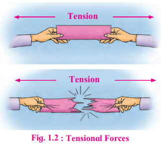
- Tensional Forces: Forces move away from each other, causing stress, ruptures, cracks, fractures, and faults in the rock strata. This leads to the formation of rift valleys or block mountains (see Fig. 1.2).
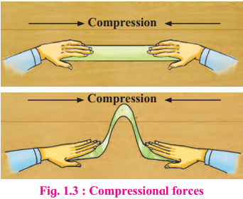
- Compressional Forces: Forces move towards each other, causing folding and faulting by compressing rock layers (see Fig. 1.3).
2. Sudden Movements
Sudden movements occur rapidly due to internal forces and are episodic in nature. They include:
a) Earthquake
- Definition: Shaking of the ground due to the release of accumulated stress in the Earth’s crust.
- Cause: Stress in rock strata accumulates and is released as energy waves, causing the crust to shake.
- Key Terms:
- Seismic Focus: The point within the crust where stress is released.
- Epicenter: The point on the surface directly above the seismic focus, where the intensity of shaking is maximum.
- Seismic Waves: Energy waves generated during an earthquake, recorded by a seismograph.
- Types of Seismic Waves:
- P-waves (Primary Waves): Pass through all mediums (solid, liquid, gas) but experience refraction.
- S-waves (Secondary Waves): Pass only through solids, not liquids.
- L-waves (Longitudinal/Surface Waves): Travel along the Earth’s surface.
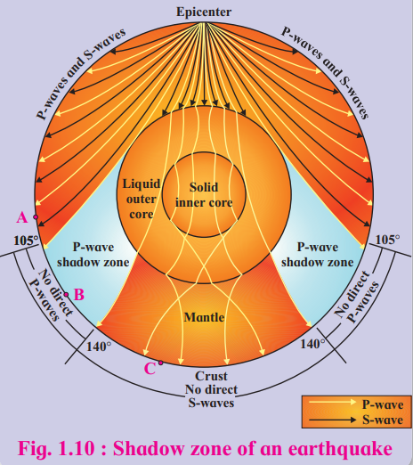
- Shadow Zone:
- A region where seismic waves are not recorded due to the Earth’s internal structure.
- P-wave Shadow Zone: Between 105° and 140° from the epicenter; P-waves are refracted by the liquid outer core.
- S-wave Shadow Zone: Beyond 105° from the epicenter; S-waves cannot pass through the liquid outer core.
- L-waves do not have a shadow zone as they travel along the surface (see Fig. 1.10).
- Measurement Scales:
- Mercalli Scale: Measures intensity based on observed effects (Roman numerals I-XII).
- Richter Scale: Measures magnitude based on seismic wave energy (e.g., magnitude 5 releases 32 times more energy than magnitude 4).
- Causes of Earthquakes:
- Volcanicity: Shallow earthquakes near volcanic eruptions (e.g., Mount St. Helens, 1981, magnitude 5.5).
- Tectonic Movements: Occur along plate boundaries (e.g., Indonesia, California, Assam in India).
- Anthropogenic Causes: Human activities like atomic explosions, large-scale mining, or construction.
b) Volcanoes
- Definition: Openings in the Earth’s surface through which gases, molten lava, and solid materials are ejected from the upper mantle.
- Classification:
- Based on Origin:
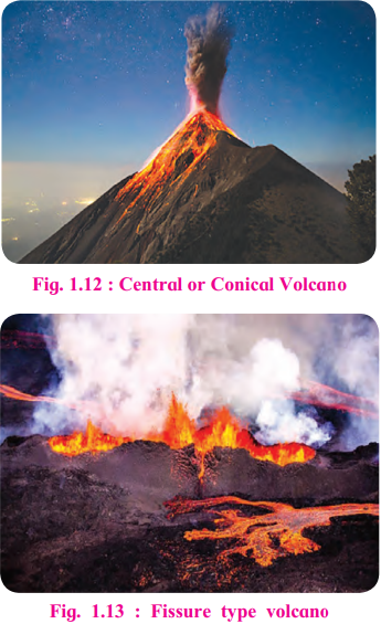
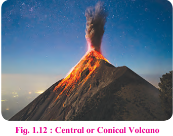
- Conical Volcanoes: Eruption through a central cone (see Fig. 1.12).
- Fissure Volcanoes: Eruption through long cracks or fissures (see Fig. 1.13).
- Based on Origin:
- Based on Activity:
- Active Volcanoes: Currently erupting (e.g., Mount Etna, Italy).
- Dormant Volcanoes: Not erupted recently but may erupt in the future (e.g., Mount Vesuvius, Italy).
- Extinct Volcanoes: No longer active (e.g., Mount Kilimanjaro, Tanzania).
- Based on Activity:
- Volcanic Materials:
- Liquid Material:
- Magma: Molten rock below the surface.
- Lava: Molten rock on the surface, classified as:
- Acidic Lava: High silica, thick, slow-moving, high melting point.
- Basic Lava: Low silica, fluid, flows longer distances, low melting point.
- Solid Material:
- Volcanic dust (fine particles), ash (small particles), breccias (angular fragments), volcanic bombs (solidified lava fragments in the air).
- Gaseous Material:
- Dark cauliflower-shaped clouds over the crater, containing inflammable gases that produce flames.
- Example: Krakatoa eruption (1883) released 25 km³ of rock particles, 21 km³ of rock fragments, ash, and gases, causing darkness for days and affecting global climate.
- Liquid Material:
Effects of Earth Movements
1. Evidences of Earth Movements
The Earth’s landforms are not permanent and change over time. Examples from the document include:
- Post-2004 Tsunami: Coast around Sumatra rose by a few centimeters.
- Formation of Himalayan Ranges: Siwaliks, Middle Himalayas, and Greater Himalayas.
- Volcanic Eruption near Iceland (1963): A new island appeared above the sea surface.
- Loss of Islands: Megapode Island disappeared after a tsunami.
- Submerged Forests: Near Mazgaon Dockyard, Mumbai, drowned forest trunks are found at depth.
- Kachchh Earthquake (1819): Submerged coastal areas, raised land forming “Allah’s Bund” (1550 sq.km).
2. Landforms Formed by Slow Movements
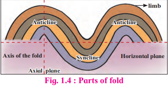
a) Folding
- Definition: Occurs when compressional forces cause ductile rocks to bend, forming folds.
- Conditions:
- Affects soft, elastic rocks deep in the crust under high pressure.
- More likely with slow application of forces.
- Parts of a Fold (see Fig. 1.4):
- Limbs: Two sides of a fold.
- Axial Plane: Divides the fold into two parts.
- Axis: Can be vertical, inclined, or horizontal.
- Anticline: Limbs slope downward, central part raised.
- Syncline: Limbs slope towards each other, central part lowered.
- Types of Folds (see Fig. 1.5):
- Symmetrical Fold: Axial plane is vertical, limbs inclined at the same angle.
- Asymmetrical Fold: Axial plane is inclined, limbs inclined at different angles.
- Overturned Fold: One limb lies above the other, limbs slope unequally in the same direction.
- Recumbent Fold: Axial plane is almost horizontal, one limb lies over the other horizontally.
- Isoclinal Fold: Limbs slope in the same direction with the same angle, axial plane varies.

- Fold Mountains:
- Formed due to folding (e.g., Himalayas, Alps, Rockies, Andes).
- Old Fold Mountains (>200 million years): Aravalis (India), Urals (Russia), Appalachians (USA).
- Young Fold Mountains (10-25 million years): Himalayas (highest peak: Mt. Everest, 8848m), Rockies.
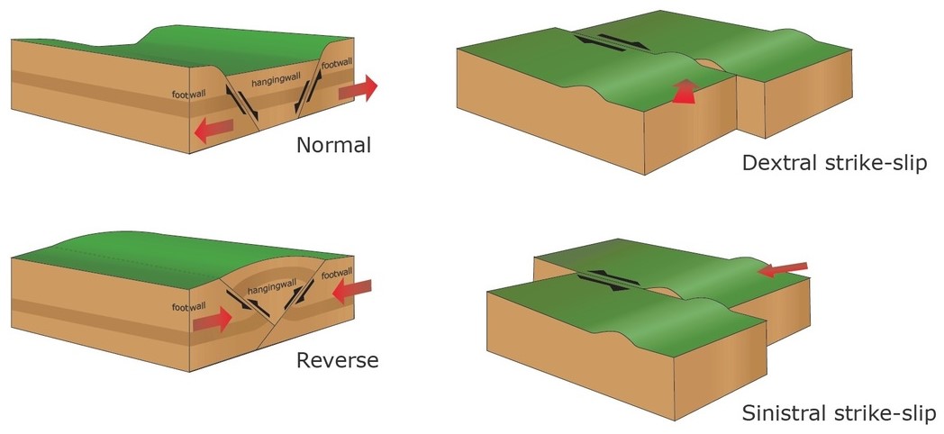
b) Faulting
- Definition: Occurs when tensional forces cause brittle rocks to break, forming cracks or fractures.
- Conditions:
- Affects rocks near the surface under low confining pressure, which are too rigid to fold.
- Results in displacement along the fracture plane (fault).
- Types of Faults (see Fig. 1.6):
- Normal Fault: One block slides downward, fault plane faces the sky.
- Reverse Fault: One block is pushed upward, fault plane faces the ground.
- Tear Fault: Horizontal movement along the fault plane, no vertical displacement.
- Thrust Fault: One block moves over another at a low angle (<45°).
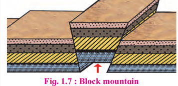
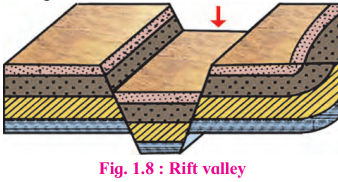
- Landforms:
- Block Mountains: Upstanding block (horst) enclosed by faults, with steep edges and a flat top (e.g., Vosges in France, Black Forest in Germany, Satpuras in Maharashtra, Meghalaya Plateau in India) (see Fig. 1.7).
- Rift Valleys: Subsidence between two faults, forming steep-walled valleys (e.g., African Rift Valley, Narmada and Tapi Valleys in India) (see Fig. 1.8).
3. Landforms Formed by Sudden Movements
a) Earthquake-Related Landforms
- Earthquakes cause immediate surface changes, such as ground shaking, landslides, and tsunamis (e.g., 2018 Indonesia earthquake killed 300 people, collapsed buildings, and triggered a tsunami).
b) Volcanic Landforms
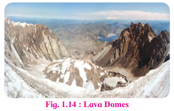
Lava Domes: Formed by solidified magma around the volcano’s mouth; shape depends on lava fluidity (acidic lava forms steep domes, basic lava forms low domes) (see Fig. 1.14).
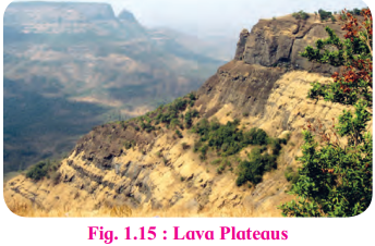
Lava Plateaus: Formed by large-scale lava flows from fissure volcanoes (e.g., Deccan Trap in India) (see Fig. 1.15).
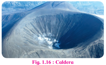
Caldera: Large depression after a massive eruption (e.g., Crater Lake, Oregon) (see Fig. 1.16).
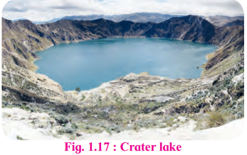
Crater Lake: Extinct volcano crater filled with rainwater (e.g., Lonar Crater Lake, India) (see Fig. 1.17).
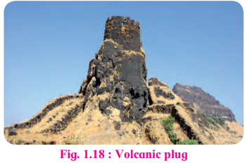
Volcanic Plug: Lava solidifies in the volcanic neck (e.g., Shiprock, New Mexico) (see Fig. 1.18).
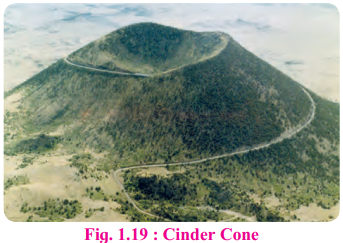
Cinder Cone: Conical hill of ash, cinder, and breccias (e.g., Mt. Nuovo, Italy) (see Fig. 1.19).
Composite Cone: Alternating layers of lava and cinder, symmetrical shape (e.g., Mt. St. Helens, USA) (see Fig. 1.21).
Distribution of Earthquakes and Volcanoes
Major Belts (see Fig. 1.20):
- Circum-Pacific Belt (Ring of Fire):
- Includes volcanoes along the eastern and western Pacific coasts.
- Features high volcanic cones (e.g., Cotopaxi, highest volcanic mountain; Fujiyama, Japan; Mt. St. Helens, USA; Pinatubo, Philippines).
- Mid-Atlantic Belt:
- Volcanoes along the Mid-Atlantic Ridge (e.g., Iceland, a highly active volcanic area).
- Mid-Continental Belt:
- Includes volcanoes in the Alpine mountain chains, Mediterranean Sea, and eastern Africa fault zones (e.g., Stromboli, Etna).
Earthquake Zones in India
- India is divided into five seismic risk zones based on damage intensity (refer to the document’s weblink for details).
Key Concepts and Questions
1. How to Locate an Earthquake’s Epicenter
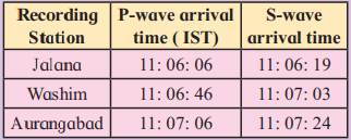
- Procedure (see Fig. 1.11):
- Compute the time lag between P-wave and S-wave arrivals at seismograph stations.
- Convert time lag to distance (1 second = 8 km).
- Convert distance to map scale (1 cm = 18 km).
- Draw circles around each station with the calculated radius.
- The intersection point of the circles is the epicenter.
2. Think About It
- Compressional Forces on Brittle Rocks: Brittle rocks break under compressional forces, forming faults rather than folds.
- Folds in Block Mountains and Faults in Fold Mountains: Folds can occur in block mountains due to secondary compressional forces, and faults can form in fold mountains due to tensional forces during upliftment.
3. Do You Know?
- Isoseismal Line: An imaginary line on a map connecting places of uniform earthquake intensity.
- Kachchh Earthquake (1819): Submerged coastal areas, raised land known as “Allah’s Bund.”
Leave a Reply