
Earth Movements – Solutions
Q. 1) Complete the chain :
Answer:
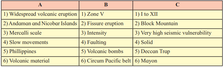
| A | B | C |
| (1) Widespread volcanic eruption | (1) Fissure eruption | (1) Deccan Trap |
| (2) Andaman and Nicobar Islands | (2) Zone V | (2) Very high seismic vulnerability |
| (3) Mercalli scale | (3) Intensity | (3) I to XII |
| (4) Slow movements | (4) Faulting | (4) Block Mountain |
| (5) Philippines | (5) Circum Pacific belt | (5) Mayon |
| (6) Volcanic material | (6) Volcanic bombs | (6) Solid |
Q. 2) Identify the correct correlation :
A : Assertion; R : Reasoning
1) A : Faulting leads to development of fold mountains.
R : Faulting occurs when tensional forces move away from each other.
1) Only A is correct
2) Only R is correct
3) Both A and R are correct and R is the correct explanation of A.
4) Both A and R are correct but R is not the correct explanation of A.
Answer: 2) Only R is correct
Explanation: Faulting does not lead to the development of fold mountains; folding does. Fold mountains are formed due to compressional forces, not faulting. However, the reasoning (R) is correct as faulting occurs when tensional forces move away from each other, causing cracks or fractures in the crust.
2) A : Intensity of an earthquake is a measurement of the energy released during an earthquake.
R : Mercallis scale is used to measure intensity of an earthquake.
1) Only A is correct
2) Only R is correct
3) Both A and R are correct and R is the correct explanation of A.
4) Both A and R are correct but R is not the correct explanation of A.
Answer: 4) Both A and R are correct but R is not the correct explanation of A.
Explanation: The assertion (A) is incorrect because the intensity of an earthquake refers to its observed effects, not the energy released (which is measured by magnitude). The reasoning (R) is correct as the Mercalli scale measures earthquake intensity based on observed effects. However, R does not explain A correctly since A misrepresents intensity.
3) A : South-East Asia, Japan and islands in the Pacific Ocean are most vulnerable to earthquakes and volcanic eruption.
R : They are located in ‘Ring of Fire’.
1) Only A is correct
2) Only R is correct
3) Both A and R are correct and R is the correct explanation of A.
4) Both A and R are correct but R is not the correct explanation of A
Answer: 3) Both A and R are correct and R is the correct explanation of A.
Explanation: The assertion (A) is correct as these regions are highly prone to earthquakes and volcanic eruptions. The reasoning (R) is also correct and explains A, as the “Ring of Fire” is a major belt around the Pacific Ocean known for frequent seismic and volcanic activity.
Q. 4) Give geographical reasons :
A) Symmetrical fold
Isoclinal fold
Overturned fold
Recumbent fault
Correct Group: 1) Symmetrical fold, 2) Isoclinal fold, 3) Overturned fold
Explanation: The document lists types of folds as Symmetrical, Isoclinal, Overturned, and Recumbent (not “Recumbent fault”). “Recumbent fault” is incorrect as the document refers to “Recumbent fold.” Therefore, the correct group includes Symmetrical, Isoclinal, and Overturned folds, but excludes “Recumbent fault.”
B) Black Forest
Vosges
Himalayas
Satpuras
Correct Group: 1) Black Forest, 2) Vosges, 4) Satpuras
Explanation: The document identifies Black Forest, Vosges, and Satpuras as examples of block mountains formed due to faulting. The Himalayas, however, are fold mountains formed by folding, not faulting. Thus, the correct group for block mountains is Black Forest, Vosges, and Satpuras.
C) Narmada Valley
African Valley
Tapi Valley
Rhine Valley
Correct Group: 1) Narmada Valley, 2) African Valley, 3) Tapi Valley
Explanation: The document mentions Narmada Valley, Tapi Valley, and African Rift Valley as examples of rift valleys formed by faulting and subsidence. Rhine Valley is not mentioned as a rift valley in the document, so it does not belong to this group.
D) Caldera
Crater lake
Cinder Cone
Lava plateau
Correct Group: 1) Caldera, 2) Crater lake, 3) Cinder Cone, 4) Lava plateau
Explanation: The document lists all four—Caldera, Crater lake, Cinder Cone, and Lava plateau—as types of volcanic landforms formed by volcanic eruptions. Therefore, this group is correct as all are volcanic landforms.
Q. 4) Give geographical reasons :
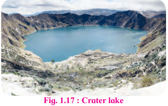
1) Extinct conical volcanoes often form crater lakes.
Answer: When an extinct conical volcano ceases to erupt, its crater (a funnel-shaped depression at the summit) can collect rainwater over time. Since the volcano is no longer active, there is no molten lava or volcanic activity to fill or disrupt the crater. The accumulated rainwater forms a crater lake, as seen in figures like Fig. 1.17 in the document.
2) People living in the Himalayas are more vulnerable to earthquakes.
Answer: The Himalayas are located along a tectonic plate boundary where the Indian Plate is converging with the Eurasian Plate, causing significant tectonic activity. This region experiences frequent earthquakes due to compressional forces and faulting, making it a high-risk seismic zone. The young fold mountains are still tectonically active, increasing vulnerability.
3) L-waves do not have a shadow zone.
Answer: L-waves (longitudinal or surface waves) travel along the Earth’s surface and do not penetrate deep into the Earth’s interior like P-waves or S-waves. Since they are confined to the surface, they are not affected by the Earth’s internal structure (e.g., mantle or core) and thus do not experience refraction or blocking, resulting in no shadow zone.
4) Soft rocks form folds while hard rocks form faults.
Answer: Soft rocks are ductile and flexible, allowing them to bend under compressional forces, leading to folding. Hard rocks, being brittle and rigid, cannot bend easily and instead break under stress, forming faults. This is due to the differing responses of rock types to tectonic forces, as explained in the document under folding and faulting.
5) Folds depend on the strength of rocks and intensity of forces.
Answer: The formation of folds is influenced by the strength and elasticity of rocks and the intensity and duration of compressional forces. Soft, elastic rocks under high-pressure conditions deep in the crust are more likely to fold without breaking. The intensity of forces determines the extent and type of folding, as stronger forces can create more complex folds.
Q. 5) Answer in detail :
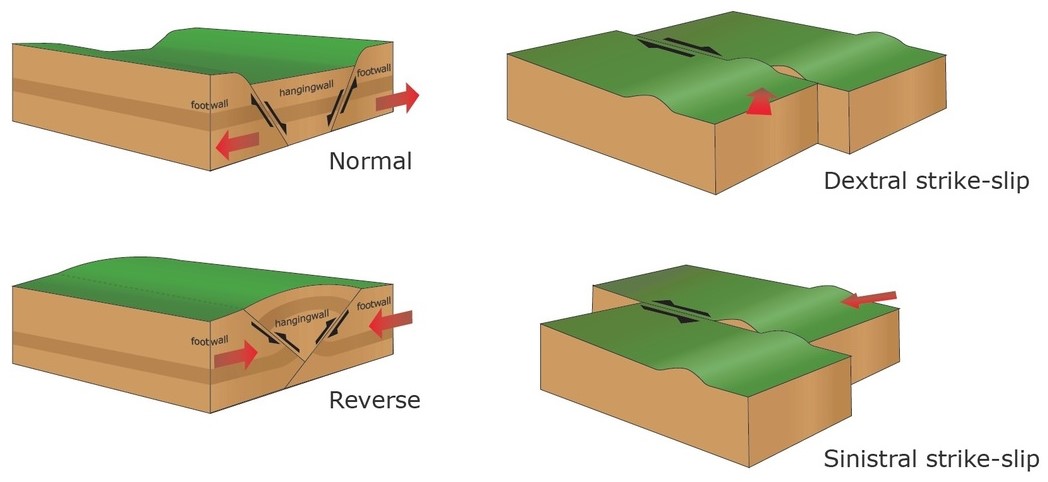
1) Explain different types of faults.
Answer: Faults are fractures in the Earth’s crust where rock masses move relative to each other. The document describes four types of faults, classified based on the direction of displacement:
- Normal Fault: Occurs when tensional forces pull the crust apart, causing one portion of the land to slide downward along the fault plane. The exposed fault plane faces the sky. Example: Common in rift valleys.
- Reverse Fault: Results from compressional forces pushing one portion of the land upward relative to the other side. The fault plane faces the ground. Example: Found in thrust belts.
- Tear Fault: Involves horizontal movement along the fault plane without significant vertical displacement. The rock strata on either side slide past each other laterally. Example: San Andreas Fault.
- Thrust Fault: A low-angle fault (less than 45°) where one portion of the land is detached and moves over the other side. Example: Common in mountain-building regions like the Himalayas.
These faults result from tectonic forces and lead to landforms like block mountains and rift valleys.
2) Explain with examples, different types of landforms produced by volcanic eruption.
Answer: Volcanic eruptions create various landforms due to the cooling and solidification of magma. The document highlights the following:
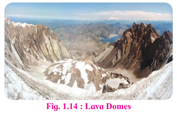
- Lava Domes: Formed when magma solidifies around the volcano’s mouth. Acidic lava creates high, steep domes, while basic lava forms broad, low domes. Example: Lava domes in Yellowstone National Park.
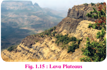
- Lava Plateaus: Created by large-scale lava flows from fissure volcanoes, covering vast areas. Example: The Deccan Trap in India, formed millions of years ago.
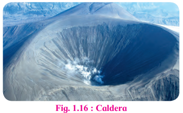
- Caldera: A large depression formed after a massive eruption relieves pressure, leaving a deep basin. Example: Crater Lake in Oregon, USA, which is a caldera filled with water.
- Crater Lake: Formed when the crater of an extinct volcano fills with rainwater. Example: Lonar Crater Lake in India.
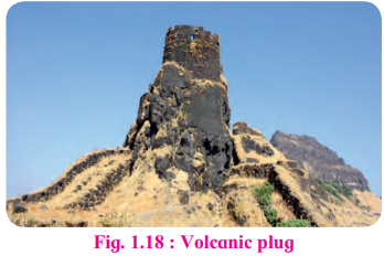
- Volcanic Plug: Occurs when lava solidifies in the volcanic neck. Example: Shiprock in New Mexico, USA.
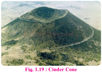
- Cinder Cone: A conical hill formed by the accumulation of ash, cinder, and breccias around the volcano’s mouth. Example: Mt. Nuovo in Italy.
- Composite Cone: Built from alternating layers of lava and cinder, creating a symmetrical cone. Example: Mt. St. Helens, USA.
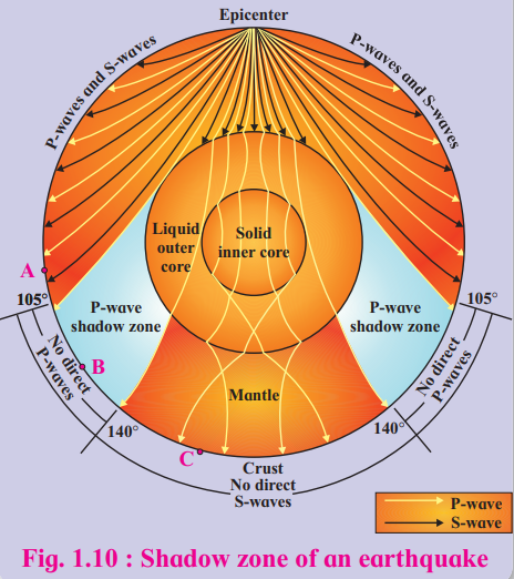
3) Explain the concept of shadow zone.
Answer: The shadow zone is an area on the Earth’s surface where seismic waves from an earthquake are not detected due to the refraction and blocking of waves by the Earth’s internal structure. Seismic waves include P-waves (primary, pass through all mediums), S-waves (secondary, pass only through solids), and L-waves (surface waves). The document explains:
- P-wave Shadow Zone: Between 105° and 140° from the epicenter, P-waves are refracted by the Earth’s liquid outer core, preventing their detection in this zone.
- S-wave Shadow Zone: Beyond 105° from the epicenter, S-waves do not reach because they cannot pass through the liquid outer core, resulting in a larger shadow zone.
- Seismographs within 105° record both P- and S-waves, while those beyond 140° record only P-waves. The shadow zone’s extent depends on the epicenter’s location and the Earth’s internal composition, as shown in Fig. 1.10.
4) Write a note on volcanic materials.
Answer: Volcanic eruptions release materials in three forms: liquid, solid, and gaseous, as detailed in the document:
- Liquid Material: Consists of molten rock, known as magma when below the surface and lava when it reaches the surface. It is classified into:
- Acidic Lava: High silica content, thick, slow-moving, with a high melting point.
- Basic Lava: Low silica content, more fluid, flows longer distances, with a low melting point.
- Solid Material: Includes volcanic dust (fine particles), ash (small particles), breccias (angular fragments), and volcanic bombs (lava that solidifies in the air before falling). These materials accumulate to form landforms like cinder cones.
- Gaseous Material: Forms dark, cauliflower-shaped clouds over the crater, containing inflammable gases that produce flames. Example: During the 1883 Krakatoa eruption, massive amounts of ash, dust, and gases were ejected, affecting global climate.
These materials shape volcanic landforms and influence the surrounding environment.
Q. 6) Differentiate between :
1) Folding and faulting
Answer:
- Folding: Occurs when compressional forces cause ductile rocks to bend, forming folds like anticlines and synclines. It leads to fold mountains (e.g., Himalayas).
- Faulting: Occurs when tensional or compressional forces cause brittle rocks to break, forming fractures or faults. It leads to block mountains or rift valleys (e.g., Vosges).
2) Normal fault and Reverse fault
Answer:
- Normal Fault: One block slides downward along the fault plane due to tensional forces, with the fault plane facing the sky. Common in rift valleys.
- Reverse Fault: One block is pushed upward relative to the other due to compressional forces, with the fault plane facing the ground. Common in thrust belts.
3) Syncline and Anticline
Answer:
- Syncline: A fold where limbs slope toward each other, with the central part at a lower elevation.
- Anticline: A fold where limbs slope downward, with the central part raised upward.
4) Asymmetrical fold and Symmetrical fold
Answer:
- Asymmetrical Fold: The axial plane is inclined, and limbs are inclined at different angles.
- Symmetrical Fold: The axial plane is vertical, and limbs are inclined at the same angle.
5) Mercalli scale and Richter scale
Answer:
- Mercalli Scale: Measures earthquake intensity based on observed effects (e.g., damage to structures), expressed in Roman numerals (I–XII).
- Richter Scale: Measures earthquake magnitude based on seismic wave energy, expressed numerically (e.g., 5.0). A magnitude 5 releases 32 times more energy than a magnitude 4.
6) Slow movements and sudden movements
Answer:
- Slow Movements: Gradual tectonic processes like vertical (epeirogenic) or horizontal (orogenic) movements, forming continents, plateaus, or mountains over millions of years.
- Sudden Movements: Rapid events like earthquakes and volcanic eruptions, causing immediate surface changes within seconds or hours.
Q. 7) Draw diagrams for :
1) Types of folds

2) Types of faults
3) Shadow zone
4) Volcanic landforms
Leave a Reply