
Agents of Erosion – Solutions
Q. 1) Complete the table :
Answer:
| Agent | Erosional/Depositional features | Places / Regions |
| (1) River | (1) Waterfalls | (1) Jog |
| (2) Wind | (2) Loess | (2) China |
| (3) Sea waves | (3) Beach | (3) Diveagar |
| (4) Glaciers | (4) Matterhorn | (4) Swiss Alps |
| (5) Ground water | (5) Caves | (5) Meghalaya |
Q. 2) Choose the correct option by identifying the correct correlation in the sentences :
1) Water or snow enters the cracks in the rocks and makes it weak. When the glacier passes on these rocks, it pulls the rocks at the bottom along with it. This process is called
a) Plucking b) Abrasion
c) Attrition d) Transportation
Answer: a) Plucking
- Explanation: Plucking is the process where a glacier exerts pressure on rocks, uprooting them as it moves, as described in the document.
2) Sometimes, the river starts erosion upstream. This happens when the head stream gets a lot of water in the early stages of river’s flow.
a) Downcutting b) Headward erosion
c) Lateral erosion d) Vertical erosion
Answer: b) Headward erosion
- Explanation: Headward erosion occurs when a river erodes backward in its source region, often due to increased water flow, as noted in the document.
3) Soft rock erodes beneath the hard rock due to sea waves. This results into landforms which further develop as sea arches. The landform is
a) Sea cave b) sea stack
c) sea cliff d) wave cut platform
Answer: a) Sea cave
- Explanation: Sea caves form when waves erode softer rock beneath harder rock, which can eventually develop into sea arches, as per the document.
4) This landform develops due to depositional work of wind. The windward slope of this landform is gentle.
a) Loess plains b) barchans
c) Seif d) Sand hills
Answer: b) Barchans
- Explanation: Barchans are crescent-shaped dunes with a gentle windward slope, formed by wind deposition, as described in the document.
5) River, glacier, wind, sea waves and groundwater are the agents of erosion. Following work in the correct order is responsible to form various landforms.
a) Disintegration, picking up, transportation, weathering
b) picking up, disintegration, deposition, weathering
c) deposition, transportation, picking up, disintegration
d) disintegration, picking up, transportation, deposition
Answer: d) disintegration, picking up, transportation, deposition
- Explanation: The document outlines that landforms are formed through the sequence of disintegration (breaking down), picking up (erosion), transportation, and deposition.
Q. 3) Give geographical reasons :
1) The Eastern coast of India have deltas formed by the rivers but the Western coast has estuaries.
Answer: The Eastern coast has gentle slopes and rivers like the Ganga carry high sediment loads, depositing them at the coast to form deltas where the sea is shallow. The Western coast, with its steep slopes and deeper seas, has rivers with lower sediment loads, leading to estuaries instead of deltas.
2) There is direct relationship between the velocity of the agents and the process of deposition.
Answer: The velocity of agents like rivers or wind determines their carrying capacity. When velocity decreases (e.g., due to a change in slope or obstacles), the agent’s ability to carry sediments reduces, leading to deposition, as explained in the document.
3) Compared to all the agents, sea waves work ceaselessly.
Answer: Sea waves operate continuously due to constant tidal and wind-driven movements, unlike rivers or glaciers, which may be seasonal or limited by geographic conditions, making their erosional and depositional work relentless.
4) One finds many sheep rocks, horns, arêtes and hanging valleys in the Himalayas.
Answer: The Himalayas, with high altitudes and snowfall, are ideal for glacier formation. Glacial processes like plucking and abrasion create features like horns, arêtes, and hanging valleys, while roche moutonnees (sheep rocks) form due to glacial smoothing.
5) Karst landforms are seen concealed under the surface of the earth.
Answer: Karst landforms, such as caves and sinkholes, form underground where acidic groundwater dissolves soluble rocks like limestone. These processes occur beneath the surface, concealing the landforms until they collapse or are exposed.
6) Snowline decides the limit of glacier work as an agent of erosion.
Answer: The snowline marks the altitude above which snow accumulates and glaciers form. Below this line, melting occurs, limiting glacial erosion, as glaciers require persistent ice to erode effectively.
Q. 4) Write short notes on :
1) Attrition
Answer: Attrition is the process where rocks and pebbles collide during transport by agents like wind, waves, or rivers, breaking into smaller, rounded fragments. This reduces particle size and smoothens edges, as seen in riverbeds or coastal areas.
2) The work of rivers in hilly areas and human activities
Answer: In hilly areas, rivers flow at high speeds, eroding beds more than banks, forming gorges, canyons, and V-shaped valleys. Waterfalls and potholes also develop. Humans use these areas for hydropower generation, irrigation, and tourism (e.g., visiting Jog Falls), but activities like deforestation can increase erosion.
3) Conditions necessary for work of wind.
Answer: Wind erosion requires:
- Aridity: High evaporation and low precipitation leave loose sediments.
- Sparse vegetation: Lack of plant cover exposes soil to wind.
- Loose materials: Dry, unconsolidated sediments are easily picked up.
- High wind velocity: Strong winds are needed to lift and transport particles, as seen in deserts.
Q. 5) Distinguish between :
1) Attrition and Abrasion
Answer:
| Attrition | Abrasion |
| (i) Attrition is the process of erosion in which rocks and pebbles bump into each other. | (i) Abrasion is the process of erosion which involves scratching and polishing of the surface of bedrock. |
| (ii) In attrition, the rocks and pebbles break up into smaller fragments. | (ii) In abrasion, the rock particles rub against and wear away the surface. |
| (iii) The eroded bedrock on surface have a smooth side. | (iii) The pebbles or rocks become smooth and rounded. |
| (iv) Attrition relates to the material that moves. | (iv) Abrasion affects the surface along which the material moves. |
2) U shaped valley and V shaped valley
Answer:
| U shaped valley | V shaped valley |
| (i) It is an erosional feature formed by glaciers as an agent of erosion. | (i) It is an erosional feature formed by river as an agent of erosion. |
| (ii) The glacier moves through pre-existing valley to form U-shaped valleys. | (ii) The river carves out its own valleys. |
| (iii) Due to lateral erosion the valley becomes broad at the bottom. | (iii) Due to vertical downcutting, the valley deepens. |
3) Stalactite and stalagmite
Answer:
| Stalactite | Stalagmite |
| (i) Water saturated with calcium carbonate drips onto the floor from the ceiling. This dripping water dries and builds massive structures. These structures growing from the ceiling are called stalactites. | (i) Water saturated with calcium carbonate drips onto the floor from the ceiling. This dripping water deposited on the floor dries forming structures are called stalagmite. |
4) Tributaries and distributaries
Answer:
| Tributaries | Distributaries |
| (i) When a number of small rivers join the main river, those are called tributaries. | (i) When the main river breaks up into smaller streams, those the called distributaries. |
| (ii) It may originate from glaciers, lakes or springs. | (ii) It is formed from the main river. |
| (iii) Generally, it does not change its course. | (iii) It diverts from the main river in the delta region. |
| (iv) Tributaries add water to the main river. | (iv) Distributaries (take away) divert water from the main river. |
| (v) River Yamuna is a tributary of river Ganga. | (v) River Hooghly is the distributary of River Ganga. |
Q. 6) Answer in detail :
1) Explain the landforms formed by different agents through the process of abrasion.
Answer:
- Glaciers: Abrasion smooths bedrock, forming roche moutonnees (rounded hills with a smooth upper side) as glaciers grind rock surfaces.
- Sea Waves: Waves abrade cliffs, creating wave-cut platforms (flat surfaces at the base of cliffs) and smoothing coastal rocks.
- Wind: Wind carrying sand polishes rocks into ventifacts (smooth, faceted rocks) and erodes the base of rocks to form mushroom rocks.
- Rivers: Abrasion by sediment-laden water smooths riverbeds, contributing to pothole formation through grinding actions.
- Abrasion involves particles wearing down surfaces, shaping distinct landforms based on the agent’s medium and velocity.
2) Explain how the depositional work done by river Ganga has been beneficial to human activities.
Answer:
- The Ganga’s depositional work creates fertile floodplains by depositing nutrient-rich alluvium, supporting agriculture in states like Uttar Pradesh and Bihar, where crops like rice and wheat thrive.
- Deltas, like the Sundarbans, form from sediment deposition, providing land for settlement and fishing.
- Natural levees along banks protect against minor floods, enabling safe habitation and farming.
- Deposited sediments improve soil fertility, supporting millions of livelihoods. The Ganga’s delta also hosts biodiversity, aiding eco-tourism and fisheries, while its navigable channels facilitate trade and transport.
3) Which agents of erosion can you see on the cover page of the textbook? Which landforms can you see there? Write the process of formation of any one.
Answer:
- Assumption: The cover page likely depicts common erosional agents (rivers, glaciers, waves, wind, groundwater). Let’s assume it shows a river and a V-shaped valley.
- Agent: River.
- Landform: V-shaped valley.
- Process of Formation: In hilly areas, rivers flow swiftly, eroding the bed more than the banks through downcutting. Over time, this vertical erosion, combined with weathering of valley sides, forms a narrow valley with steep, V-shaped slopes. The process is enhanced by the river’s kinetic energy, which removes rock material, as seen in mountainous regions like the Himalayas.
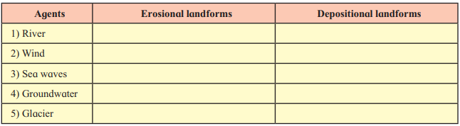
Q. 7) Draw neat and labelled diagrams for :
1) Deflation
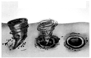
2) Wave-cut platform
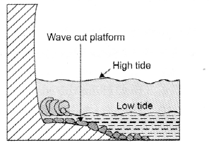
3) Mushroom rocks
Leave a Reply