
Climatic Regions – Solutions
Q. 1) Write the names of climatic regions according to the factors that dominate their characteristics :
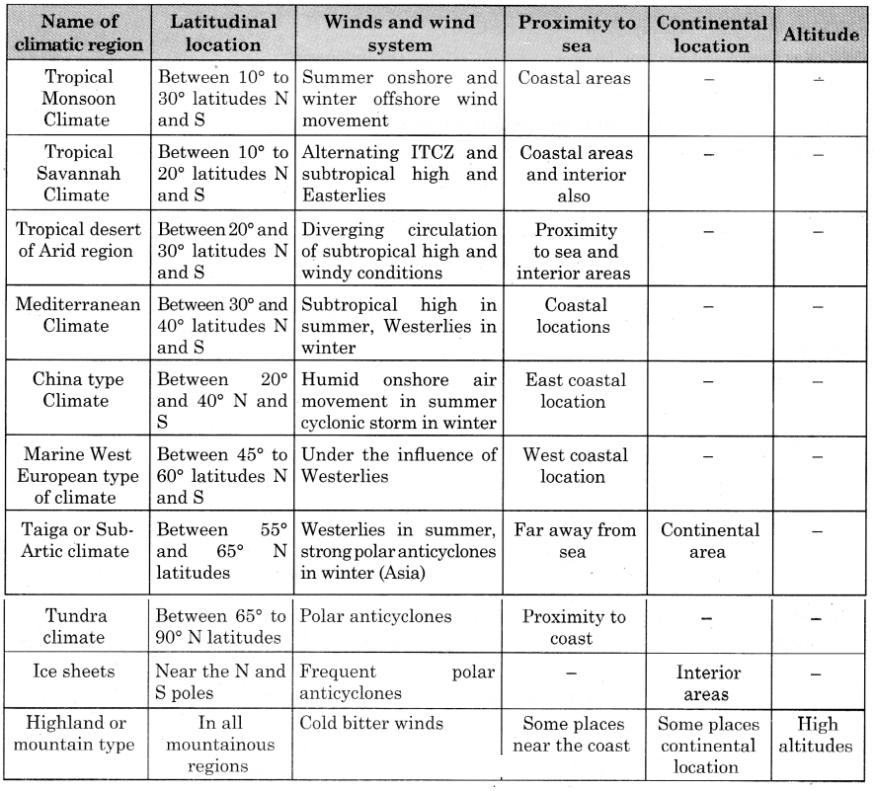
Answer:
Q. 2) Choose the correct alternative :
1) Monsoon region
a) annual average temperature around 27° C
- >2500 mm annual precipitation
- Indonesia
- Hard-wood evergreen trees
b) Average temperature in Summers around 35° C
- < 2500 mm annual rainfall
- South East Asia
- Hard wood deciduous trees
c) Temperatures in summer around 35° C
- 1000 mm annual rainfall
- Continental part of Indian peninsula
- Tall and thick grass
d) Average temperatures in summer around 27° C
- 1000 mm rainfall in winter
- South Africa
- Hard–wooded, waxy, evergreen forests
Answer: (b) Average temperature in Summers around 35° C
- < 2500 mm annual rainfall
- South East Asia
- Hard wood deciduous trees
2) The region with high diurnal range of temperature :
a) Tropical rainforests
b) Tropical grasslands
c) Tropical desert regions
d) Tropical Monsoon regions
Answer: c) Tropical desert regions
- Explanation: Tropical deserts have the highest diurnal temperature range due to clear skies, low humidity, and rapid heat loss at night, with summer temperatures of 30–45°C and winter temperatures of 20–25°C
3) Lumbering flourished as an occupation from the Newfoundland to Alaska in North America because :
a) Tundra Climatic Region
b) Taiga Climatic Region
c) West European Climatic Region
d) China-type climatic region
Answer: b) Taiga Climatic Region
- Explanation: The Taiga region, spanning northern North America (Newfoundland to Alaska), has coniferous forests with soft, light wood ideal for lumbering
4) The main reason behind the months of precipitation in the graphs of Monsoon climatic regions being different is :
a) ITCZ
b) orographic rainfall
c) hemispheres are different
d) apparent movement of the sun
Answer: a) ITCZ
- Explanation: The shifting of the Inter-Tropical Convergence Zone (ITCZ) due to the apparent movement of the Sun causes seasonal rainfall variations in Monsoon regions.
Q. 3) Give geographical reasons:
1) In Monsoon climate region, rainfall occurs in specific season.
Answer: Reason: Rainfall in the Monsoon climate region is seasonal due to the shifting of the ITCZ and differential heating of land and sea. In summer, the ITCZ moves north, creating low pressure over land, attracting moisture-laden winds from the sea, causing heavy rainfall. In winter, the ITCZ shifts south, and dry northeast monsoon winds dominate, resulting in a dry season.
2) Taiga region is not found in Southern Hemisphere.
Answer: Reason: The Taiga region is absent in the Southern Hemisphere because there are fewer landmasses at high latitudes (55°–65°S) compared to the Northern Hemisphere. The Southern Hemisphere at these latitudes is mostly oceanic, with minimal land (e.g., southern Chile, no permanent settlements), limiting the development of Taiga vegetation and climate .
3) The diurnal range of temperature is more in desert areas.
Answer: Reason: Desert areas have a high diurnal temperature range due to low humidity, minimal cloud cover, and dry air, which allow intense daytime heating (up to 45°C) and rapid heat loss at night (down to 20–25°C). The lack of moisture and vegetation further enhances this range.
4) There is no concept of season in equatorial regions.
Answer: Reason: Equatorial regions, located within 5°–10° of the equator, receive nearly vertical Sun rays year-round, resulting in consistent high temperatures (around 27°C) and heavy rainfall (2500–3000 mm) throughout the year. The stable insolation and lack of significant seasonal shifts in the ITCZ eliminate distinct seasons.
5) The Savannah region is prone to droughts.
Answer: Reason: The Savannah region experiences distinct wet and dry seasons due to the alternating influence of the ITCZ (wet summers) and subtropical high-pressure belts (dry winters). During the dry season, rainfall is minimal (250–1000 mm annually), and the region’s location peripheral to rainforests limits moisture availability, making it prone to droughts.
6) Though Mussoorie and Dehradun are located on the same latitude, why is their climate different?
Answer: Reason: Mussoorie and Dehradun differ in climate due to their altitudinal difference. Mussoorie, located at a higher altitude in the Himalayas, experiences a cooler highland climate with lower temperatures and orographic rainfall. Dehradun, at a lower elevation, has a warmer climate typical of the plains, with less influence of altitude-driven cooling.
Q. 4) Differentiate between :
1) Rainforests and Savannah Climatic Regions
| Aspect | Rainforests | Savannah |
|---|---|---|
| Location | 5°-10° N and S (Amazon, Congo, Indonesia) | 10°-20° N and S (parts of India, Africa, Brazil) |
| Temperature | Constant ~27°C, no distinct seasons | Summer ~35°C, winter ~24°C, distinct wet/dry seasons |
| Rainfall | Heavy, 2500-3000 mm, evenly distributed | 250-1000 mm, wet summers, dry winters |
| Vegetation | Dense, three-layered hardwood trees, high biodiversity | Tall grasses (e.g., elephant grass), scattered trees, less biodiversity |
| Soils | Iron-rich, chemical weathering dominant | Less fertile, supports grazing |
| Human Activity | Tribal habitation, limited agriculture | Grazing, animal husbandry, some agriculture |
2) Taiga and Tundra regions
| Aspect | Taiga | Tundra |
|---|---|---|
| Location | 55°-65° N (North America, Eurasia) | 65°-90° N (Arctic borders, Greenland) |
| Temperature | Brief cool summers (~15-20°C), very cold winters (<0°C) | Summer ~10°C, winter -20 to -30°C |
| Rainfall | 300-500 mm, snow in winter | 300-500 mm, mostly snow, low evaporation |
| Vegetation | Coniferous forests (softwood), acidic soils | Low shrubs, swamps during melting, permafrost |
| Proximity to Sea | Continental, away from seas | Coastal, maritime influence moderates winters |
| Human Activity | Lumbering, hunting, experimental crops | Hunting, fishing, mineral exploration |
3) Monsoon and Mediterranean Regions
| Aspect | Monsoon | Mediterranean |
|---|---|---|
| Location | 10°-30° N and S, coastal SW India, SE Asia | 30°-40° N and S, western coasts (Mediterranean Sea, California) |
| Temperature | Summer 27-32°C, winter 15-24°C | Summer 21-27°C, winter 10-14°C |
| Rainfall | 250-2500 mm, summer orographic rainfall | 500-1000 mm, winter rainfall |
| Seasons | Distinct wet summer, dry winter due to ITCZ shift | Dry summer, wet winter due to westerlies in winter |
| Vegetation | Jungles to thorn forests, paddy rice agriculture | Scrub, evergreen forests, olives, grapes, citrus |
| Winds | Seasonal monsoon winds (onshore summer, offshore winter) | Subtropical highs in summer, westerlies in winter |
Q. 5) Answer in detail :
1) Explain, with examples, the effect of latitude on a place’s climate.
Answer:
- Latitude significantly influences a place’s climate by determining the angle of insolation and the position relative to global wind and pressure systems.
- Equatorial Regions (5°–10° N/S): Near the equator, vertical Sun rays provide consistent high insolation, resulting in high temperatures (~27°C) and heavy rainfall (2500–3000 mm), as seen in the Amazon Basin . The ITCZ remains stationary, causing year-round rain and no distinct seasons.
- Tropical Regions (10°–30° N/S): Slightly higher latitudes, like the Savannah (10°–20° N/S) in south-central Africa, experience seasonal shifts of the ITCZ, leading to distinct wet (summer, ~35°C) and dry (winter, ~24°C) seasons with 250–1000 mm rainfall.
- Mid-Latitudes (30°–60° N/S): Regions like the Mediterranean (30°–40° N/S) in Central California receive moderate insolation, with warm, dry summers (~21–27°C) and mild, wet winters (~10–14°C) due to alternating subtropical highs and westerlies.
- High Latitudes (60°–90° N/S): Near the poles, oblique Sun rays cause low insolation, leading to cold climates like the Tundra (65°–90°N) with summer temperatures ~10°C and winter temperatures –20 to –30°C, as in Greenland.
- Latitude thus governs temperature, precipitation, and seasonal patterns by controlling insolation and atmospheric circulation.
2) Explain, with examples, how winds affect the climate of a place.
Answer: Winds influence climate by transporting moisture, heat, and pressure systems, shaping temperature and precipitation patterns.
- Monsoon Winds: In the Tropical Monsoon region (e.g., SW India), summer southwest monsoon winds bring moisture from the sea, causing heavy orographic rainfall (250–2500 mm). In winter, dry northeast monsoon winds result in a dry season.
- Westerlies: In the Marine West European climate (e.g., Western Europe), prevailing westerlies bring moist air from the Atlantic, moderated by warm ocean currents like the North Atlantic Drift, resulting in year-round precipitation (500–2500 mm) and mild winters (~5°C).
- Trade Winds and ITCZ: In Equatorial Rainforests (e.g., Congo Basin), converging trade winds form the ITCZ, causing heavy convectional rainfall (2500–3000 mm) year-round due to rising moist air.
- Polar Anticyclones: In the Ice Cap climate (e.g., Antarctica), polar anticyclonic winds limit precipitation to meager snowfall, maintaining extremely cold conditions (all months below 0°C) due to dry, descending air.
- Winds thus determine moisture availability, temperature moderation, and precipitation type across climatic regions.
3) Russia is larger than Chile in area but does not experience climatic diversity as Chile. Explain.
Answer: Russia, despite its vast size, has less climatic diversity than Chile due to differences in latitudinal span, topography, and geographical orientation.
- Latitudinal Span: Russia spans mid-to-high latitudes (50°–70°N), primarily experiencing cold climates like Taiga (55°–65°N, brief summers ~15–20°C, cold winters <0°C) and Tundra (65°–90°N, summer ~10°C, winter –20 to –30°C).
- Its northern orientation limits exposure to warmer tropical or subtropical climates. Chile, though smaller, extends from 17°S to 56°S, covering tropical, Mediterranean, Marine West European, and even highland climates due to its longitudinal stretch.
- Topography: Chile’s Andes Mountains create altitudinal climatic zones, from coastal deserts (e.g., Atacama due to Humboldt Current) to highland climates with orographic rainfall and snowfall.
- Russia’s flatter terrain, dominated by plains and plateaus, lacks such vertical diversity, with continental climates prevailin.
- Proximity to Sea: Chile’s narrow, coastal geography ensures maritime influence, moderating climates (e.g., Marine West European in southern Chile with mild winters ~5°C).
- Russia’s largely continental interior, far from oceans, experiences extreme temperature ranges and low precipitation (e.g., Taiga’s 300–500 mm).
- Ocean Currents: Chile’s climate is influenced by the cold Humboldt Current (causing arid conditions) and warm currents in the south-the only significant ocean current affecting Chile is the Benguela Current, which contributes to the Kalahari Desert’s aridity.
- Russia lacks such diverse oceanic influences, with colder currents dominating its northern coasts.
- Thus, Chile’s elongated shape, altitudinal variation, and oceanic proximity create greater climatic diversity compared to Russia’s more uniform, cold, continental climate.
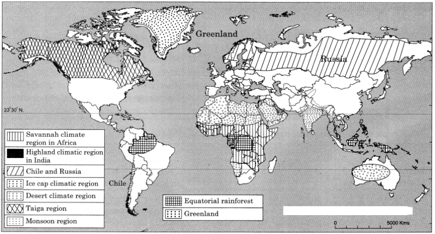
Q. 6) On a world map, show the following areas :
1) Savannah climatic region in Africa
2) Highland climatic region in India
3) Chile and Russia
4) Ice cap climatic region
5) Desert climatic region
Answer:
Leave a Reply