
Indian Ocean – Relief and Strategic Importance
Q. 1) Complete the chain :
Answer:
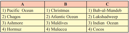
| A | B | C |
| (1) Pacific Ocean | (1) Atlantic Ocean | (1) Indian Ocean |
| (2) Chagos | (2) Christmas | (2) Lakshadweep |
| (3) Ashmore | (3) Maldives | (3) Cocos |
| (4) Hormuz | (4) Malacca | (4) Bab-al-Mandeb |
Q. 2) Give geographical reasons:
1) Salinity is less in the Bay of Bengal in Indian Ocean.
Answer: The Bay of Bengal experiences lower salinity due to the large influx of freshwater from major river systems, such as the Ganga and peninsular rivers. These rivers discharge significant amounts of freshwater into the bay, diluting the seawater. Additionally, the region receives heavy rainfall during the southwest monsoon, further reducing salinity, especially during this season.
2) The eastern coastal part of Indian Ocean is seismically active.
Answer: The eastern coastal part of the Indian Ocean is seismically active because it lies along the converging plate boundary between the Indo-Australian Plate and the Pacific Plate. This tectonic interaction results in frequent earthquakes and volcanic activity, particularly around features like the Java/Sunda Trench, where subduction occurs.
3) Gyre develops in Southern Indian Ocean.
Answer: A gyre develops in the Southern Indian Ocean due to the combined effect of the South Equatorial Current, which flows east to west under the influence of easterlies, and the West Wind Drift, which flows west to east under westerlies. The circulation is completed by the Mozambique-Agulhas currents in the west and the West Australian Current in the east, forming a large-scale oceanic gyre.
4) Temperatures are high in pre-monsoon season in equatorial region in northern Indian Ocean.
Answer: Temperatures are high in the pre-monsoon season (approaching summer solstice) in the equatorial region of the northern Indian Ocean because of increased solar insolation near the equator. The proximity to the equator results in higher solar radiation, leading to elevated sea surface temperatures during this period.
Q. 3) Write short notes on :
1) The width of continental shelf in Bay of Bengal and Arabian Sea.
Answer: The continental shelf in the Arabian Sea is relatively wide, especially along the western coast of India, where it extends significantly due to sediment deposition from terrestrial erosion. In contrast, the continental shelf in the Bay of Bengal is narrower along the eastern coast of India and the western coast of Sumatra, though it is broader in some areas due to sediment from rivers like the Ganga. The variation is influenced by coastal geomorphology and sediment supply, with the Arabian Sea having more extensive shelves compared to the narrower shelves along the Indonesian coast (approximately 160 km).
2) Mineral resources in Indian Ocean
Answer: The Indian Ocean is rich in mineral resources, including poly-metallic nodules found on abyssal plains, which contain nickel, copper, manganese, and cobalt. Beach sands along the coasts of India, South Africa, Indonesia, and Sri Lanka are rich in heavy minerals. Additionally, offshore deposits of hydrocarbons, such as oil and natural gas, are actively exploited in regions like Saudi Arabia, Iran, India, and Western Australia, contributing significantly to global energy supplies.
3) Ocean currents in Indian Ocean
Answer: Ocean currents in the Indian Ocean are influenced by monsoon winds and the region’s unique geography. In the northern Indian Ocean, currents reverse seasonally: clockwise during the southwest monsoon and anticlockwise during the northeast monsoon. Major currents include the South Equatorial Current (east to west), the West Wind Drift (west to east), and the Mozambique-Agulhas and West Australian currents, which form a large gyre in the southern Indian Ocean. These currents facilitate heat transfer and water mixing across the ocean.
4) Oil and natural gas in Indian Ocean
Answer: The Indian Ocean is a significant source of hydrocarbons, with large reserves of oil and natural gas being extracted from offshore areas of Saudi Arabia, Iran, India, and Western Australia. Approximately 40% of the world’s offshore oil production comes from the Indian Ocean. The Persian Gulf, in particular, is a major hub for crude oil exports, transported through strategic routes like the Strait of Hormuz, making the region critical to global energy markets.
Q. 4) Answer in detail:
1) Outline the importance of Indian Ocean with respect to trade and transport routes
Answer: The Indian Ocean is a vital artery for global trade and transport, connecting Asia, Africa, and Australia with Europe and the Americas. It serves as a primary route for the transportation of petroleum and petroleum products from the oilfields of the Persian Gulf and Indonesia, with key chokepoints like the Strait of Hormuz, Malacca, and Bab-el-Mandeb facilitating the movement of approximately 30% of global oil exports. The ocean supports major economies, including those of India, ASEAN countries, and Gulf nations, with trade volumes growing significantly, such as India’s imports from Southeast Asia reaching $10,942 million in 2004. The Indian Ocean also hosts critical sea lanes for maritime trade, with increasing importance due to free trade agreements with countries like Thailand and Singapore. However, the rise in piracy, armed robbery, and maritime terrorism underscores the need for robust sea-lane defense, adding complexity to its strategic importance.
2) Evaluate the strategic location of India with respect to its location in Indian Ocean
Answer: India’s central location in the Indian Ocean positions it as a pivotal player in regional geopolitics and trade. Situated between Africa, Asia, and Australia, India has direct access to key maritime routes, including the Strait of Hormuz and the Strait of Malacca, which are critical for global oil and trade flows. This location enhances India’s role in securing sea lanes and countering maritime threats like piracy and terrorism. Economically, India’s dependence on oil imports (70% from the Gulf region) underscores the ocean’s importance for energy security. India’s foreign policy, through initiatives like the Indian Ocean Rim Association for Regional Cooperation and BIMSTEC, aims to foster peace and cooperation among littoral states, countering superpower rivalry. The presence of naval and military bases in the region, such as Diego Garcia, highlights the strategic significance of India’s location, necessitating a strong naval presence to protect its shores and economic interests.
3) Explain the Indian Ocean with respect to the following aspects:
a) Ocean Trenches
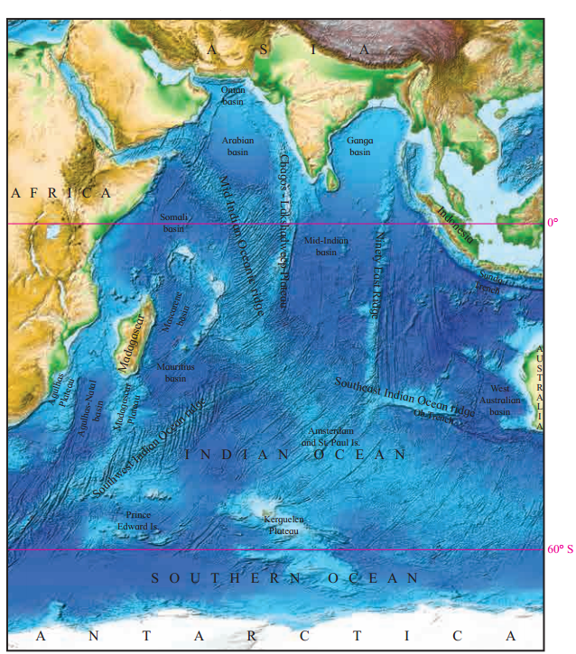
Answer: The Indian Ocean has fewer trenches compared to other oceans, with most located along its eastern boundary near the converging Indo-Australian and Pacific plates. The most notable is the Java/Sunda Trench, with a depth of 7,450 meters, followed by the Ob Trench at 6,875 meters. These trenches are seismically active due to tectonic plate movements, contributing to earthquakes and volcanic activity in the region.
b) Abyssal Plains
Answer: Abyssal plains in the Indian Ocean are deep, flat areas on the ocean floor that serve as terminal destinations for sediments from continents and oceanic sources. These plains are rich in poly-metallic nodules containing valuable minerals like nickel, copper, manganese, and cobalt. India has been allocated 2 million square kilometers by the International Seabed Authority for research and excavation of these nodules, highlighting their economic potential.
c) Ridges
Answer: The Indian Ocean features prominent mid-oceanic ridges, such as the Mid-Indian Oceanic Ridge, which originates from the Gulf of Aden and splits into the Southwest Indian Ocean Ridge and a southeast branch extending to Amsterdam and St. Paul Islands. The Ninety East Ridge, a long north-south range in the Bay of Bengal, extends from west of the Andaman and Nicobar Islands to the eastern part of Amsterdam and St. Paul Islands. These ridges are formed by tectonic and volcanic processes and are often discontinuous due to fracture zones like the Owen and Amsterdam fracture zones.
d) Ocean Currents
Answer: Ocean currents in the Indian Ocean are driven by monsoon winds and the region’s geography. In the northern Indian Ocean, currents reverse seasonally: clockwise during the southwest monsoon and anticlockwise during the northeast monsoon. In the southern Indian Ocean, a large gyre is formed by the South Equatorial Current (east to west), the West Wind Drift (west to east), and the Mozambique-Agulhas and West Australian currents. These currents play a crucial role in heat transfer, water mixing, and influencing regional climate patterns, such as the monsoon system.
Q. 5) On an outline map of the world, locate the following and make an index :
1) Sunda Trench
2) Diego Garcia
3) SW Monsoon
4) Agulhas Current
5) West Australian Current
6) Ninety East ridge
7) Strait of Holmuz
8) Chabahar port
Answer:
Leave a Reply