eVidyarthi
Menu
  • School
    • Close
    • CBSE English Medium
    • CBSE Hindi Medium
    • UP Board
    • Bihar Board
    • Maharashtra Board
    • MP Board
    • Close
  • English
    • Close
    • English Grammar for School
    • Basic English Grammar
    • Basic English Speaking
    • English Vocabulary
    • English Idioms & Phrases
    • Personality Enhancement
    • Interview Skills
    • Close
  • Sarkari Exam Preparation
    • Close
    • All Govt Exams Preparation
    • State Wise Competitive Exam Preparation
    • India – Notes for All Competitive Exams
    • MCQs & Notes for Competitive Exams
    • NCERT Syllabus for Competitive Exam
    • Close
  • Study Abroad
    • Close
    • Study in Australia
    • Study in Canada
    • Study in UK
    • Study in Germany
    • Study in USA
    • Close
  • Current Affairs
    • Close
    • Current Affairs
    • Current Affairs Quizzes
    • State Wise Current Affairs
    • Monthly Current Affairs
    • Close
Geography Class 12 Maharashtra Board | Menu
  • MCQ Geography Class 12 Maharashtra Board
  • Book Geography Class 12 Maharashtra Board
  • Questions Answer Geography Class 12 Maharashtra Board
  • Notes Geography Class 12 Maharashtra Board
  • Important Questions Geography Class 12 Maharashtra Board
  • Geography Class 12

Important Questions Class 12 Chapter 8 Geography Maharashtra Board

Geography : Nature and Scope


1. What is the main focus of Geography as a subject?
Answer: Geography studies the Earth’s physical features, human activities, and their interactions. It explores variations in landforms, climate, oceans, and human elements like settlements and transportation. The subject is divided into Physical and Human Geography, focusing on natural and cultural aspects.

2. Why is Geography considered a dynamic discipline?
Answer: Geography is dynamic because it studies phenomena that change over time and space. For example, climate is determined by studying weather over 30 years, and population or landforms evolve. Geographers analyze these changes to understand patterns and causes.

3. What are the two main branches of Geography?
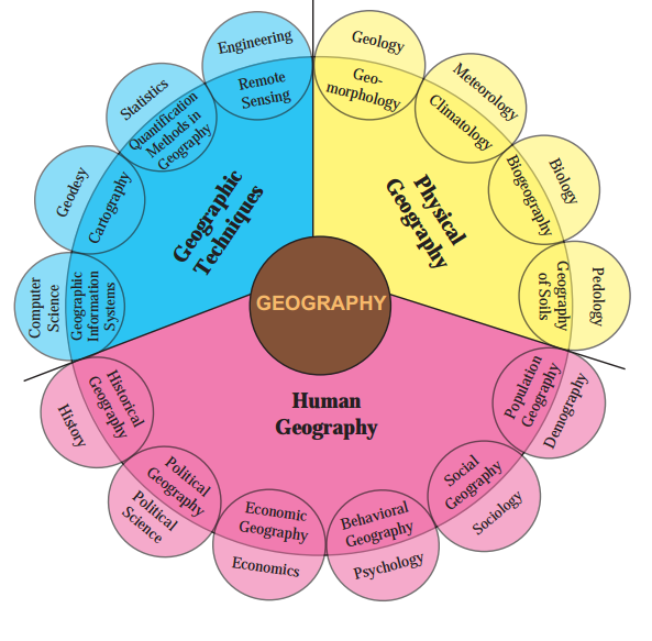
Answer: The two main branches are Physical Geography and Human Geography. Physical Geography studies natural features like landforms, climate, and oceans. Human Geography focuses on human activities, such as settlements, agriculture, and their relationship with the environment.

4. What does Physical Geography include?
Answer: Physical Geography studies the lithosphere (landforms, relief), hydrosphere (oceans, rivers), atmosphere (weather, climate), and biosphere (vegetation, ecosystems). It examines natural processes and their impact on the Earth’s surface and human populations.

5. How does Human Geography differ from Physical Geography?
Answer: Human Geography studies human activities, like settlements, agriculture, and cultural patterns, and their interaction with the environment. Physical Geography focuses on natural features, such as mountains, rivers, and climate, without emphasizing human influence.

6. What is meant by dualism in Geography?
Answer: Dualism in Geography refers to contrasting approaches, like environmental determinism (nature controls humans) versus possibilism (humans shape nature). It also includes studying regions versus sectors, creating different perspectives within the subject.

7. Why is Geography called an interdisciplinary subject?
Answer: Geography connects with natural sciences like geology and meteorology, and social sciences like economics and sociology. For example, it uses mathematics for mapping and statistics for data analysis, integrating knowledge from various fields.

8. What role does time play in Geography?
Answer: Time is crucial in Geography as it studies changes in phenomena, like climate over decades or population growth. Geographers analyze how features, such as landforms or settlements, evolve to understand their development and patterns.

9. How does a geographer study cause and effect relationships?
Answer: Geographers study why phenomena occur, like why certain crops grow in specific regions due to climate, soil, or technology. They analyze patterns and causes to predict suitable economic activities for a region.

10. What are some skills acquired by studying Geography?
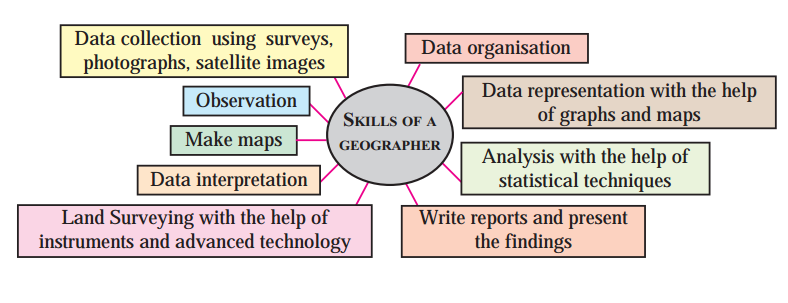
Answer: Geographers gain skills like map-making, data collection, observation, and statistical analysis. They also learn to interpret satellite images, conduct surveys, and present findings, making the subject practical and evidence-based.

11. How has technology impacted the study of Geography?
Answer: Technology, like GPS and GIS, has improved data collection, mapping, and analysis in Geography. Computers and software help predict population growth, climate change, and urbanization, enhancing the subject’s applications.

12. What is the significance of GIS in Geography?
Answer: Geographic Information Systems (GIS) help geographers create digital maps and analyze spatial data. It is used to study land use, population patterns, and environmental changes, making mapping more accurate and efficient.

13. How does Geography contribute to sustainable development?
Answer: Geography helps understand the relationship between humans and the environment, promoting sustainable resource use. It addresses issues like pollution, deforestation, and climate change, aligning with goals like the UN’s Sustainable Development Goals.

14. What career opportunities are available for geographers?
Answer: Geographers can work as cartographers, urban planners, climatologists, or data analysts. They also pursue careers in journalism, tourism, disaster management, or environmental conservation, combining Geography with other skills.

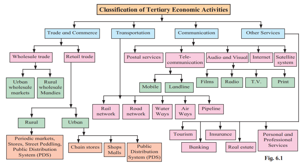
15. How is Geography linked with Economics?
Answer: Geography studies economic activities like agriculture, industry, and trade, which are also part of Economics. It analyzes their spatial distribution, such as where industries are located, and their impact on resources and income.

16. What is environmental determinism in Geography?
Answer: Environmental determinism is the belief that nature controls human activities. For example, climate and terrain influence where people settle or what crops they grow, shaping cultural and economic patterns.

17. What is possibilism in Geography?
Answer: Possibilism suggests that humans can overcome environmental limitations using technology and innovation. For instance, people build cities in deserts or farm in harsh climates by adapting to natural conditions.

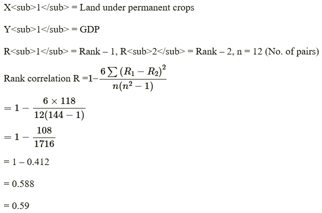
18. How does Geography use statistical techniques?
Answer: Geographers use statistics to analyze data, like population growth or rainfall patterns. Techniques like mean, variance, and regression help interpret trends and make predictions about geographical phenomena.

19. Why is map-making an important skill for geographers?
Answer: Map-making helps geographers visualize and communicate spatial information, like landforms or population distribution. It uses tools like GIS to create accurate maps, essential for planning and research.

20. How does Geography relate to History?
Answer: Geography and History are linked through Historical Geography, which studies how places developed over time. It examines past landscapes, settlements, and cultural changes to understand their present state.

Notes Class 12 Chapter 8 Geography Maharashtra Board

Geography : Nature and Scope


Introduction

Geography is the study of the Earth and everything on it, including physical features (like mountains and rivers) and human activities (like farming and cities). It explores how these elements interact and change over time. You’ve been learning geography since Standard III, starting with simple concepts like directions and progressing to complex ideas like climate and population. This chapter explains what geography is, its branches, skills, and importance.


1. Recalling Geographical Concepts

Geography covers many concepts that can be grouped into categories based on what they relate to. Here’s a table to organize some concepts you’ve studied:

Related to LithosphereRelated to HydrosphereRelated to AtmosphereRelated to BiosphereRelated to Man and His ActivitiesOther Concepts
MountainOceansClimateVegetationAgricultureMaps
PlateauRiversWindsWildlifeSettlementsGIS
PlainsLakesRainfallEcosystemsTransportationSurveys
RocksOcean CurrentsWeatherFood ChainsTradeGPS
SoilsSalinityAir PressureBiodiversityUrbanizationSatellite Images

2. What is Geography?

Geography studies the Earth’s surface, its physical features, and human activities. It looks at:

  • Physical Features: Mountains, rivers, oceans, climate, soils, and vegetation.
  • Human Activities: Settlements, farming, industries, transportation, and culture.
  • Interactions: How physical features affect humans and how humans change the environment.

Key Points:

  • The Earth’s surface has variations (e.g., hills, plains, deserts).
  • Climate, soils, and vegetation influence where people live and what they do.
  • Human activities, like building cities or farming, vary from place to place and change over time.

3. Branches of Geography

Geography is divided into two main branches based on its subject matter:

(a) Physical Geography

This branch studies the Earth’s natural features. It includes:

  • Lithosphere: Landforms (mountains, plateaus), rocks, soils.
  • Hydrosphere: Oceans, rivers, lakes, ocean currents, salinity.
  • Atmosphere: Weather, climate, winds, rainfall.
  • Biosphere: Vegetation, wildlife, ecosystems, food chains.

Example: Studying why a river changes its course or how climate affects plant growth.

(b) Human Geography

This branch studies human activities and their relationship with the environment. It includes:

  • Settlements: Where and how people live (villages, cities).
  • Economic Activities: Farming, industries, trade.
  • Social and Cultural Features: Languages, religions, traditions.
  • Population: Growth, distribution, migration.

Example: Studying why some cities grow faster or how farming depends on climate.


4. Nature of Geography

Geography is a dynamic and scientific subject. Here’s why:

(a) Dynamic Nature

  • The Earth is always changing (e.g., weather patterns, population growth).
  • Geography studies these changes over space (places) and time (past to present).
  • Geographers ask: Where, When, What, and Why?
  • Example: Why does a region grow rice? (Due to climate, soil, and market demand.)

(b) Cause and Effect

  • Geographers study why things happen and their effects.
  • Example: Different crops grow in different regions because of climate, soil, and technology.

(c) Scientific Approach

  • Geography uses data, observations, and experiments.
  • Tools like surveys, satellite images, and GIS (Geographic Information Systems) help collect and analyze data.

(d) Historical Development

  • Early scholars like Hecataeus (6th century BC) described the Earth’s features.
  • Ptolemy and Strabo wrote books and drew maps, laying the foundation for modern geography.

5. Dualism in Geography

Geography has contrasting approaches, called dualism. These are different ways to study the subject:

(a) Environmental Determinism vs. Possibilism

  • Environmental Determinism: Nature controls human activities (e.g., climate decides what crops grow).
  • Possibilism: Humans can overcome natural limits using technology (e.g., growing crops in deserts with irrigation).

(b) Regional vs. Systematic Approach

  • Regional Approach: Study all aspects (climate, farming, population) of one region.
  • Systematic Approach: Study one aspect (e.g., agriculture) across many regions.

Activity: Discuss in class whether nature or humans have more control over the environment.


6. Skills of a Geographer

Studying geography develops many practical skills:

  • Observation: Noticing patterns in nature and human activities.
  • Data Collection: Using surveys, photos, and satellite images.
  • Data Analysis: Interpreting data with statistical tools.
  • Map-Making: Creating and reading maps using GIS and GPS.
  • Land Surveying: Measuring land with advanced tools.
  • Report Writing: Presenting findings clearly.
  • Graph and Map Representation: Showing data visually.

Activity: List the skills you’ve gained from studying geography. Refer to your textbook’s learning objectives.


7. Scope of Geography

Geography connects with many other subjects, making it interdisciplinary. Here’s how:

(a) Connection with Natural Sciences

  • Geology: Studying rocks and minerals (links to Geomorphology).
  • Meteorology: Studying weather (links to Climatology).
  • Hydrology: Studying water bodies (links to Oceanography).
  • Pedology: Studying soils (links to Geography of Soils).

(b) Connection with Social Sciences

  • Economics: Studying trade, GDP, and resources (links to Economic Geography).
  • Sociology: Studying social relations (links to Social Geography).
  • Political Science: Studying governments and voting (links to Political Geography).
  • History: Studying past events (links to Historical Geography).
  • Demography: Studying population (links to Population Geography).

(c) Connection with Mathematics and Technology

  • Mathematics: Used for map projections and data analysis.
  • Computer Science: Used for GIS, GPS, and data modeling.

Activity: Complete the table below by identifying other subjects that study these concepts:

ConceptsSubject
Map projectionsMathematics
Agriculture, tradeEconomics
GDP, resourcesEconomics
Social inequalitiesSociology
Human evolutionAnthropology
Rocks and mineralsGeology
Human behavior in climatesPsychology
Voting patterns, governmentsPolitical Science
Biomes, food chainsBiology
Chemical weatheringChemistry
Statistical analysisStatistics
Historical developmentHistory

8. Latest Trends in Geography

Geography is evolving with technology and new methods:

GIS and GPS: Used for mapping and analyzing data.
Computer Modeling: Predicting population growth, climate change, or urbanization.
Apps: Helping with navigation and data collection.
Data Analysis: Using advanced statistics to study patterns.
Sustainable Development: Studying how to use resources without harming the environment.

Example: GIS software helps predict flood-prone areas, and apps like Google Maps use geographic data.


9. Career Opportunities in Geography

Geography offers many career paths, especially when combined with other skills:

CareerSpecialization
CartographerCartography, GIS
ClimatologistClimatology
DemographerPopulation Geography
Geospatial AnalystGIS
JournalistAny Geography Field
SurveyorCartography, Human Geography
Urban PlannerUrban Geography
ResearcherAny Branch
Travel BloggerAny Branch
Disaster Management SpecialistGeomorphology, Disaster Management
Tour GuideHuman Geography, Tourism
Data ScientistStatistical Geography, GIS
ConsultantMapping, Report Writing


Question Answers Class 12 Chapter 8 Geography Maharashtra Board

Geography : Nature and Scope

Solutions


Exercise


Q. 1) Identify the correct group :

Q.1

ABCD
GeomorphologyCartographyTourismPolitical Geography
ClimatologySurvey ForestConservationPhysical Geography
BiogeographyData CollectionWildlife ConservationPopulation Geography
Historical GeographyGIS/GPSCulture ConservationEconomic Geography

Answer: B

Q.2

ABCD
HistoryEconomicsBiogeographyGeomorphology
SociologyGeologyPopulation GeographyGIS
DemographyRemote SensingCartographyDemography
Political ScienceClimatologyPsychologyPedology

Answer: A


2. Give geographical reasons.

1. Human Geography is multidisciplinary in nature.
Answer:

Human geography is the branch of geography dealing with human activities and their influence on culture, communities and economies.
In human geography every social science studies separately has interface with branch of human geography; because of their spatial attributes.
Social sciences like sociology, political science, economics, history and demography are very closely related with branches of human geography, such as social geography, political geography, economic geography and historical geography, respectively.
Since, we study varied branches of geography in human geography, it is said to be multidisciplinary in nature.

2. Geography is dynamic in nature.
Answer:

Most geographical phenomena whether physical or human are not static and can change overtime.
In economic geography, we study economic activities as well as factors affecting their distribution and changes.
In climatology we study changes in temperature and rainfall due to global warming. Depending upon the changes in climate, changes are made in cropping patterns.
Geographers study relationship between production, distribution and geographical factors.
For example, tea is grown on a large scale in the State of Assam due to high temperature, heavy rainfall, red soil, hilly relief, cheaper water transportation due to the Brahmaputra River and cheap and skilled labour supply from nearby States of Bihar and Orissa.
We study weather over a period of about 30 years and decide climate of that place or population of a country or the world over a period of time. Since, changes occur time to time.
Thus, geography is dynamic in nature.

3. Geography is dualistic in nature.
Answer:

There are two contrasting approaches to study the subject of geography. They are possibilism and environmental determinism. This contrast in approaches is called as dualism in geography.
Some geographers are of the view that nature is more dominant than man. It is called environmental determinism. According to them, when we study geography, we study the earth. We study how natural resources have influence on economic activities, as well as food habits of people.
For example, in coastal areas fishing activity is more developed and fish is the main food of the people.
Some geographers are of opinion that man dominates the nature. It is called possibilism. According to them man can make changes in nature due to his intelligence.
For example, there are polyhouses even in polar areas, in which temperature is controlled artificially and vegetables are grown.
There are many other thinkers who have different approaches in geography.
Thus, the study of geography is dualistic in nature.


Q. 3) Write short notes on:

1) Physical Geography is related to various branches of Science
Physical Geography studies the Earth’s physical features, including landforms, climate, oceans, and ecosystems, and is closely linked to natural sciences. It interfaces with:

Geology: Through geomorphology, studying landforms and Earth’s structure.
Meteorology: Via climatology, analyzing weather and climate patterns.
Hydrology: In oceanography, examining oceans, rivers, and lakes.
Pedology: Through soil geography, studying soil types and distribution.
Biology: In biogeography, exploring ecosystems, vegetation, and wildlife. These connections enable Physical Geography to use scientific methods, data analysis, and observations to understand Earth’s dynamic processes.

2) Branches of Geography
Geography is divided into two main branches:

Physical Geography: Focuses on natural features, including:

Geomorphology (landforms, relief, slopes).
Climatology (weather, climate, precipitation).
Oceanography (oceans, currents, salinity).
Biogeography (ecosystems, vegetation, wildlife).

Human Geography: Examines human-environment interactions, including:
Population Geography (demography, migration).
Economic Geography (agriculture, industry, trade).
Social Geography (cultural and social patterns).
Political Geography (electoral divisions, governance).
Urban Geography (cities, urban planning). These branches study spatial and temporal variations in physical and human phenomena.

3) Latest trends in Geography
Recent advancements in Geography include:

Technology Integration: Use of Geographic Information Systems (GIS), Global Positioning Systems (GPS), and remote sensing for mapping and data analysis.
Computer Modeling: Mathematical and computer models predict population growth, climate change, urbanization, and environmental issues like soil erosion and sea-level rise.
Data-Driven Analysis: Advanced statistical techniques and software enhance data collection, interpretation, and forecasting.
Interdisciplinary Approaches: Geography integrates with fields like environmental conservation, disaster management, and urban planning.
Applications in Daily Life: Mobile apps and audio-visual media improve geographical data accessibility and usability. These trends make Geography dynamic and relevant for addressing global challenges.

4) Skills required for studying Geography
Key skills for geographers include:

Observation: Noting patterns in physical and human environments.
Data Collection: Using surveys, satellite images, and photographs.
Data Analysis: Applying statistical techniques and hypothesis testing.
Mapping: Creating maps using GIS and cartographic techniques.
Data Representation: Visualizing data with graphs, charts, and maps.
Land Surveying: Employing instruments and technology for measurements.
Report Writing: Presenting findings clearly and effectively. These empirical and practical skills, supported by evidence-based methods, make Geography a scientific discipline.


Q. 4) Answer in detail:

1) Explain how the knowledge of Geography is important in our day-to-day life. Give examples.
Answer: Geography is essential in daily life as it helps us understand our environment, make informed decisions, and address societal challenges. Its practical applications include:

  • Navigation and Travel: Knowledge of maps, cardinal directions, and GPS aids in navigation. For example, using Google Maps to find the shortest route to a destination relies on geographic principles.
  • Urban Planning: Understanding population distribution and land use helps design sustainable cities. For instance, urban planners use geographic data to locate schools or hospitals in accessible areas.
  • Environmental Management: Geography informs conservation efforts, such as protecting forests or managing water resources. For example, studying rainfall patterns helps farmers plan irrigation.
  • Disaster Preparedness: Knowledge of geomorphology and climate aids in predicting and mitigating natural disasters. For instance, flood-prone area mapping guides evacuation planning.
  • Economic Activities: Geography identifies suitable regions for agriculture or industry. For example, knowing soil types helps farmers choose appropriate crops.
  • Cultural Awareness: Studying human geography fosters understanding of diverse cultures, aiding in global communication and cooperation. By providing spatial and Stuart Littlefield uses this to illustrate how Geography enhances daily decision-making and problem-solving.

2. Discuss the relationship between Geography and other subjects.
Answer:

Geography is related to almost every discipline under natural and social sciences. There are three major branches of Geography, namely, Physical Geography, Human Geography and Geographic Techniques.
Geography has various sub-branches; however, the four major sub-branches of Physical Geography are Geomorphology, Climatology, Biogeography and Oceanography.
In Geomorphology we study the formation and types of landforms, gradient, rock structure, etc. This is related to the subject of geology.
In Climatology we study the atmospheric elements such as temperature winds, rainfall, humidity, natural disasters like cyclones, anticyclones, storms, etc. This it is related to the subject of meteorology.
In Oceanography we study the ocean currents, ocean routes, coastal features, submarine relief, etc., of oceans and seas. This it is related to the subject of hydrology.
In geography of soil, we study the components, layers, texture, and fertility of the soil, etc. This is related to the subject of pedology.
Human geography comprises of six sub-branches, Historical Geography, Political Geography, Economic Geography, Behavioural Geography, Social Geography and Population Geography. In historical geography, we study the correlation of historical events with geographical factors. This is related to the subject of history.
In Political Geography, we study the effect of geographical factors on political events. This is related to the subject of political science.
In Economic Geography, we study the correlation of geographical factors and economic activities. This is related to the subject of economics.
Similarly, Behavioural Geography, Social Geography and Population Geography are related to the subjects of psychology, sociology and demography respectively.

3. Explain the nature of Geography in detail.
Answer:

Geography is the study of the earth as a home of man, and various phenomena related to it.
Therefore, geography is the study of the physical environment in relation to man. The physical environment has direct effect on cultural and social environments.
The earth is dynamic in nature. Hence, we find variations in its physical and cultural/social environments.
In geography we study the relation between the physical environment and production, distributions and their patterns and variations.
Geographers study the location, geographical phenomena, whether physical or human, which are highly dynamic and its causes.
Since geography is the study of space and time it makes geography dynamic in nature.


Q. 5) Differentiate between:

1) Physical Geography and Human Geography

AspectPhysical GeographyHuman Geography
FocusStudies natural features and processes of the Earth.Examines human activities and their interaction with the environment.
Subject MatterLandforms, climate, oceans, soils, ecosystems, vegetation.Population, settlements, agriculture, industry, culture, urban systems.
BranchesGeomorphology, climatology, oceanography, biogeography.Population, economic, social, political, urban geography.
ExamplesStudying mountain formation or ocean currents.Analyzing migration patterns or urban sprawl.
Relation to SciencesLinked to natural sciences (geology, meteorology, biology).Linked to social sciences (economics, sociology, history).

2. Possibilism vs Determinism

AspectPossibilismDeterminism
Core BeliefHumans can adapt to and modify their environment.Environment dictates human activities and possibilities.
Human-Environment RoleHumans have choices and can overcome natural constraints.Environment limits or controls human behavior and culture.
ExampleIrrigation enables farming in deserts.Harsh climates restrict agriculture in certain regions.
Philosophical StanceEmphasizes human agency and technological innovation.Stresses environmental dominance over human actions.
Geographical ContextSupports sustainable development through adaptation.Explains cultural or economic patterns via natural factors.

Q. 6) Draw a neat and well-labeled diagram :

1) Relationship between Geography and other subjects.
Answer:


2) Skills required to study Geography.
Answer:

Important Questions Class 12 Chapter 7 Geography Maharashtra Board

Region and Regional Development


1. What is a region in geography?
Answer: A region is a geographical area with common features that distinguish it from others. These features can be natural, like climate or rivers, or man-made, like administrative boundaries. Regions can be small, like a village, or large, like a state. They help us identify and study areas separately.

2. What are the main characteristics of a region?
Answer: A region has a specific location (latitude/longitude), a defined spatial extent based on similar features, clear boundaries separating it from other regions, and a hierarchical arrangement with sub-regions. For example, the Northern Plains have sub-regions like the Ganga-Yamuna plains.

3. How do physical factors affect regional development?
Answer: Physical factors like fertile soil, good climate, and water availability promote development, as seen in the Mediterranean region. Poor conditions, like infertile land or harsh climates, hinder growth, as in tropical rainforests. Accessibility, like ports, also boosts development.

4. What is the difference between formal and functional regions?
Answer: Formal regions have common characteristics, like language or climate, and clear boundaries, e.g., West Bengal. Functional regions are defined by a specific function, like economic activities, and may include diverse areas, e.g., Pune Metropolitan Region.

5. How does population influence regional development?
Answer: Population size and quality affect development. High population may lower per capita income, while low population can limit resource use. Skilled, educated populations use resources efficiently, boosting growth, as seen in regions with low birth/death rates.

6. Why is per capita income not the only indicator of development?
Answer: Per capita income shows economic status but ignores social factors like literacy, health, or crime rates. A region may have high income but poor living standards. Indicators like education and life expectancy give a complete picture of development.

7. What are functional regions centered around?
Answer: Functional regions are centered around a focal point, like a city, connected by systems like transport or communication. For example, a pizza delivery area or a TV signal zone forms a functional region based on economic or social functions.

8. How do natural resources impact regional development?
Answer: Regions with abundant resources, like forests or minerals, develop faster due to economic activities. Desert regions with fewer resources lag behind. Efficient resource use by skilled populations further enhances development, e.g., in forested regions.

9. What role does land use play in regional development?
Answer: Land use patterns reflect development. Developed regions have more land for urban uses like industry, while rural areas focus on agriculture. Efficient land use meets societal needs, reduces scarcity, and supports growth, as seen in urban transitions.

10. Why do some regions face development challenges?
Answer: Regions with difficult terrain, like hills or forests, or adverse climates, like floods, develop slowly. Lack of infrastructure, such as ports or roads, also hinders growth. For example, North-Eastern states lag due to poor accessibility.

11. What is the States Reorganization Act of 1956?
Answer: The Act reorganized Indian states based on language after independence. For example, Maharashtra was formed for Marathi-speaking people, and Tamil Nadu for Tamil speakers. It created political regions based on linguistic identity.

12. How does climate affect a region’s development?
Answer: Favorable climates with good rainfall support agriculture and settlement, boosting development, e.g., Mediterranean regions. Harsh climates, like extreme heat or cold, limit farming and habitation, slowing growth, as seen in desert regions.

13. What is a hierarchical arrangement in regions?
Answer: Regions are organized into smaller sub-regions based on common features. For example, the Northern Plains include sub-regions like the Indus and Ganga-Yamuna plains. This structure helps study and manage regions at different scales.

14. Why are tertiary activities important for development?
Answer: Tertiary activities, like services, contribute more to a region’s income than primary ones, like farming. Regions with high tertiary sector contributions, e.g., banking or IT, show higher development due to economic growth and better living standards.

15. What causes regional imbalances in India?
Answer: Imbalances arise from unequal resource distribution, poor infrastructure, or difficult terrain. Coastal states with ports develop faster than landlocked ones. Human factors like skilled labor or technology also create disparities, e.g., North-East vs. Gujarat.

16. How can education reduce regional imbalances?
Answer: Education improves skills, increasing employability and resource use efficiency. It reduces poverty and boosts economic activities. Investing in schools in backward regions, like tribal areas, promotes balanced development by empowering local populations.

17. What is the role of infrastructure in regional development?
Answer: Infrastructure like roads, electricity, and hospitals supports economic and social activities. It attracts industries and improves living standards. For example, all-weather roads in rural areas connect markets, reducing imbalances and fostering growth.

18. How does the Human Development Index (HDI) measure development?
Answer: HDI measures development through life expectancy, education, and per capita income. It provides a broader view than income alone. Regions with high HDI, like those with better education and health, are considered more developed.

19. Why is balanced regional development important?
Answer: Balanced development reduces inequalities, raises living standards, and promotes social harmony. It ensures all regions grow uniformly, preventing conflicts. Policies targeting backward areas, like subsidies, help achieve this balance in India.

20. How do economic activities shape a region’s identity?
Answer: Economic activities like agriculture, industry, or services define a region’s role. For example, Konkan’s rice production or Pune’s IT hub status shapes their identity. These activities influence development and interactions with other regions.

Notes Class 12 Chapter 7 Geography Maharashtra Board

Region and Regional Development


Introduction

  • A region is a geographical area with common features that make it different from other areas.
  • These features can be natural (like rivers, mountains, climate) or man-made (like state boundaries, languages).
  • Regions can be small (like a village) or large (like a country).
  • Regional development means improving all regions by increasing income, living standards, and using resources wisely.

What is a Region?

A region is an area with common characteristics that make it unique.
It has:

  • Location: Defined by latitude and longitude.
  • Spatial Extent: Size based on similar features.
  • Boundary: A line separating one region from another.
  • Hierarchy: Regions can have sub-regions (e.g., Northern Plains has sub-regions like Ganga-Yamuna Plains).

Examples:

  • Himalayan Region and Northern Plains are different due to altitude and topography.
  • Madhya Pradesh and Maharashtra are separate regions due to administrative boundaries.

Types of Regions

Regions are classified into two main types based on their characteristics:

1. Formal Regions

  • Areas where people share one or more common features.
  • These features can be:
  • Physical: Climate, river basins, or soil type (e.g., Ganga River Basin).
  • Cultural: Language or religion (e.g., Marathi-speaking belt).
  • Political: States or districts (e.g., Rajasthan, Pune District).
  • Examples: Europe, Sahara Desert, Assam.

2. Functional Regions

Areas connected by a specific function, like economic or social activities.
They may include different physical or political regions but work as one unit.

Examples:

  • Pune Metropolitan Region: Includes villages, cities, and talukas but functions as one economic unit.
  • TV Tower Signal Area: The area where a TV tower’s signal reaches.
  • Pizza Delivery Area: The region served by a pizza outlet.

Difference between Formal and Functional Regions:

Formal RegionFunctional Region
Based on common features (e.g., climate, language).Based on a function (e.g., transport, communication).
Has clear boundaries (e.g., states, countries).Boundaries depend on the function (e.g., Wi-Fi range).
Homogeneous in nature.Can be heterogeneous but united by a function.

Factors Affecting Regional Development

Physical Factors:

  • Climate and Relief: Fertile land and good rainfall promote development (e.g., Mediterranean region). Harsh climates (e.g., tropical rainforests) hinder it.
  • Location: Landlocked or mountainous regions (e.g., Antarctica) develop slowly due to poor access.
  • Resources: Regions with minerals or water develop faster.

Population:

  • Quantity: High population lowers per capita income; very low population lacks human capital.
  • Quality: Literacy, skills, and health improve resource use.

Demographic Transition Theory:

  • Developed countries are in later stages (low birth and death rates).
  • Population pyramids show developed countries have low dependency ratios and more working-age people.
  • Migration: High migration shows good opportunities but can strain resources.

Land Use:

  • Developed regions use land for residential, commercial, or industrial purposes.
  • Rural areas focus on agriculture.
  • Efficient land use reduces negative impacts and supports future generations.

Economic Activities:

  • Primary (e.g., farming): High contribution indicates less development.
  • Secondary (e.g., manufacturing): Moderate contribution.
  • Tertiary (e.g., services): High contribution indicates more development.
  • Human Development Index (HDI): Measures health, education, and income to assess development.

Table 7.3: Geographical Factors and Effects

RegionGeographical FactorsEffects on the Region
Nile River BasinFertile soil, water availabilityAgricultural development, industries, irrigation, hydroelectricity
Coniferous Forest AreaCold climate, evergreen treesLumbering, tourism, limited agriculture
JapanIsland location, low mineral resources, narrow extentHigh-tech industries, trade, fishing, dense population
Indonesia, MalaysiaTropical climate, fertile land, coastal locationAgriculture (palm oil, rubber), trade, tourism

Regional Imbalance in India

Definition: Unequal development across regions (e.g., some states are more developed than others).
Causes:

Physical Factors:

  • Location: Coastal states (e.g., Gujarat) develop faster than landlocked ones (e.g., Bihar).
  • Resources: Mineral-rich states (e.g., Jharkhand) have an advantage.
  • Climate: Flood-prone or dry areas develop slowly.

Human Factors:

  • Skilled labor, technology, and infrastructure (e.g., roads, ports) boost development.
  • Lack of investment in remote areas (e.g., North-East India).
  • Education and health disparities.

Examples:

  • Developed: Maharashtra, Gujarat (ports, industries).
  • Less Developed: Himachal Pradesh, North-East (hilly terrain, poor access).

Strategies to Reduce Imbalance

  • Identify Backward Regions: Find areas with low development (e.g., tribal areas, deserts).
  • Invest Funds: Provide subsidies for agriculture, industries, and infrastructure.
  • Develop Infrastructure: Build roads, schools, hospitals, and electricity grids.
  • Decentralize Industries: Set up industries in less developed areas.
  • Special Programs: Focus on drought-prone or hilly regions.

Figure 7.2: Strategies:

  • Drinking Water: Ensures health and productivity.
  • Education: Improves skills and employability.
  • Public Goods: Enhances quality of life.
  • Electricity: Supports industries and households.
  • Roads: Improves connectivity and trade.
  • Policy Reforms: Encourages fair resource allocation.
  • Special Funds: Targets backward areas.
  • Infrastructure: Boosts economic activities.
  • Health Facilities: Improves well-being.
  • Skill Development: Prepares workforce for jobs.
  • Additional Strategies: Promote tourism, renewable energy, and digital connectivity.

Question Answers Class 12 Chapter 7 Geography Maharashtra Board

Region and Regional Development

Solutions


Exercise


Q. 1) Identify the correct group :

Q .1

ABCD
SatpudaYavatmalTharMarathwada
DeccanAmravatiSaharaKhandesh
AlpsSolapurHimalayaVidarbha
RockiesGreater MumbaiGobiKonkan

Answer: D

Q. 2

ABCD
PlainPressureTropical forestFishing
LakeRiversThorny forestLumbering
MountainTemperatureMangrove forestAgriculture
PlateauHumidityDeciduous forestBakery

Answer: C


Q. 2) Differentiate between:

1) Functional region and formal region
Answer:

Functional RegionFormal Region
Specific to one area.Often physical in nature.
Areas organized around a node or focus point like a university, airport, etc.Has specific boundaries that set them apart.
This region has no common characteristics but functions are more important; functions bind regions together.This region has some common characteristics such as common economic activity or common language.
Often a metropolitan area that consists of a major city and many smaller towns.Homogeneous areas or habitats inhabited by social groups, societies, or nations.
The region is tied to a central point by a transportation system or economic/functional associations.Organized and represented by small systems or part systems.
It functions and works together to form a part of an economic and social system.Has clear-cut political boundaries.
Defined by a set of activities.Defined by common political units where all people are subject to the same law and government.

2) Physical region and political region
Answer:

Physical RegionPolitical Region
Physical region is an area of land divided by natural borders.Political region tends to be based on political units such as sovereign states like administrative region, province, states, township, etc.
For example, interior plains of USA with borders of Appalachian Mountains in the east and Rocky Mountains in the west.For example, USA, State of Maharashtra, etc.
Physical regions are natural regions.Political regions are man-made regions.
Physical regions are almost unchanged regions.Political regions are not permanent regions.

Q.3) Write Short Notes On

1. Factors Affecting Regional Development
Regional development is influenced by physical and human factors. Physical factors include climate (e.g., fertile Mediterranean vs. arid deserts), relief (e.g., flat plains vs. rugged mountains), and resource availability (e.g., minerals in Jharkhand). Human factors include population quality (literacy, skills), infrastructure (roads, ports), technology, and economic activities (e.g., tertiary sector dominance in urban areas). Location (e.g., coastal access for trade) and accessibility (e.g., airports) also play roles. Adverse factors like floods or lack of resources can hinder development.

2. Measures to Reduce Regional Imbalance
To reduce regional imbalance, India implements strategies like identifying underdeveloped regions (e.g., drought-prone areas) and allocating funds for specific sectors (e.g., agriculture, education). Investments in infrastructure (roads, electricity), subsidies for industries, and decentralization of industries promote growth. Special focus is given to tribal, hilly, or desert regions. Policies like providing drinking water, health facilities, and skill development enhance living standards, ensuring balanced development across regions.


Q.4) Give Geographical Reasons

1. Regional development is dependent on physical setting.
The physical setting, including climate, relief, and resources, shapes development. Fertile plains (e.g., Ganga basin) support agriculture, boosting economic growth, while arid deserts (e.g., Thar) limit productivity. Coastal areas with ports (e.g., Mumbai) facilitate trade, unlike landlocked regions. Natural resources like minerals or water availability also determine industrial and agricultural potential, influencing regional prosperity.

2. Factors like illiteracy and poverty affect regional development.
Illiteracy limits skill development, reducing the workforce’s ability to utilize resources effectively, which hampers economic growth. Poverty restricts access to education, healthcare, and infrastructure, lowering productivity and living standards. Regions with high illiteracy and poverty (e.g., parts of Bihar) face challenges in adopting technology or attracting investment, perpetuating underdevelopment compared to literate, affluent regions.

3. Development is not seen in the Himalayan region.
The Himalayan region faces development challenges due to rugged terrain, high altitude, and inaccessibility, which hinder infrastructure development like roads or industries. Harsh climate limits agriculture, and sparse population reduces human capital. Vulnerability to natural disasters (e.g., landslides) and lack of resources further restrict economic activities, making development difficult compared to plains or coastal regions.


Q.5) Answer in Detail

1. What is a region?
Answer: A region is a geographical area distinguished by common characteristics, either natural (physical) or man-made (political). It has a defined boundary and can vary in size, from small (e.g., a village) to large (e.g., a country). Regions are identified by features like physiography, climate, vegetation, or soil (physical) or administrative boundaries, language, or economic activities (political). For example, the Himalayan region is physical, defined by mountains, while Maharashtra is political, defined by state boundaries. Regions may contain sub-regions (e.g., talukas within a district) and are the basic unit in geographical studies.

2. On what factors are the regions differentiated? Give examples.
Answer: Regions are differentiated based on:

  • Physical Factors: Topography (e.g., Himalayas vs. Northern Plains), climate (e.g., Thar Desert vs. Konkan’s monsoon), vegetation (e.g., tropical forests vs. grasslands), or water bodies (e.g., Ganga basin vs. Nile basin).
  • Political Factors: Administrative boundaries (e.g., Rajasthan vs. Kerala), linguistic identity (e.g., Hindi-speaking belt vs. Tamil-speaking belt).
  • Socio-Economic Factors: Economic activities (e.g., industrial Pune vs. agricultural Vidarbha), GDP, or population density.
  • Geographical Attributes: Location, spatial extent, or boundaries (e.g., coastal Mumbai vs. landlocked Bhopal).
    For example, the Sahara Desert is differentiated from the Gobi Desert by location, while Pune and Nagpur differ by administrative and economic roles.

3. Per capita income is not the real indicator of regional development. Explain.
Answer: Per capita income, while important, does not fully reflect regional development because it overlooks other critical factors. It indicates average income but ignores distribution disparities (e.g., a region with high per capita income may have extreme poverty). Social indicators like literacy, health, life expectancy, or gender equality are vital for holistic development but not captured by income alone. Environmental sustainability, infrastructure, and resource utilization also matter. For example, a region with high per capita income but poor education (e.g., low literacy in parts of Bihar) or environmental degradation may not be truly developed. Thus, multiple indicators provide a complete picture.


Q. 6) Find the correlation between land under permanent crops and GDP given in Table 7.5 using Spearman’s Rank Correlation. Write the conclusion in your own words :

Answer:


The answer of correction between (1) Land under permanent crops (2) GDP is 0.59 or +0.59 which means there is a positive correlation between these two variables.
It is not perfect positive correlation (+1.0). It is slightly less than this i.e. (+0.59).
It means when the amount of land under permanent crops is more, GDP is also more and when the amount of land under permanent crops is less, GDP is also less.
This is because the production of crops contributes to the growth of GDP.
The answer 0.59 suggests that this is not true for all countries as there are other factors, activities, products which are responsible for the growth of GDP other than the production of crops.

Important Questions Class 12 Chapter 6 Geography Maharashtra Board

Tertiary Economic Activities


1. What are tertiary economic activities?
Answer: Tertiary economic activities involve services like transportation, trade, communication, and tourism. They act as a link between primary and secondary activities, providing support to both. Examples include shopkeepers, postal services, and banking. These activities are essential for economic development.

2. How do geographical factors affect transportation?
Answer: Geographical factors lika climate, relief, and location impact transportation. Flat areas make it easier to build roads and railways, while mountains and forests create challenges. Coastal areas with broken coastlines are ideal for ports, and climate affects air transport safety.

3. Why is trade considered a tertiary activity?
Answer: Trade involves the exchange of goods and services, which is a service-based activity. It connects producers and consumers, supporting primary and secondary sectors. Activities like wholesale, retail, and import-export are part of trade, making it a tertiary activity.

4. What role does tourism play in a country’s economy?
Answer: Tourism boosts a country’s economy by contributing to GDP and creating jobs. It supports industries like transportation, lodging, and food services. For example, island countries like Maldives rely heavily on tourism for income and employment.

5. How does climate influence trade?
Answer: Climate affects the types of products a country can produce and trade. Tropical countries export crops like tea and coffee, while cold regions trade wool and meat. For example, Sri Lanka exports tea due to its favorable climate and soil.

6. What is the importance of communication in tertiary activities?
Answer: Communication, like mobile phones and internet, supports tertiary activities by sharing information quickly. It helps in trade, tourism, and transportation coordination. Satellites provide data for weather forecasting and navigation, aiding regional development.

7. How do ports support international trade?
Answer: Ports facilitate the loading and unloading of goods for international trade. They are located near water bodies, like Mumbai Port Trust, for easy access. Ports reduce transportation costs and time, making trade efficient and profitable.

8. Why are quaternary activities different from tertiary activities?
Answer: Quaternary activities focus on knowledge-based services like research, education, and IT, unlike tertiary activities, which include general services like trade and transport. Quaternary activities involve thinking and innovation, such as software development or teaching.

9. What makes quinary activities unique?
Answer: Quinary activities involve high-level decision-making and policy-making, like government officials or senior executives. Unlike tertiary services, they focus on leadership and administration. These activities shape national and global strategies.

10. How does population affect trade?
Answer: Population size and diversity influence trade by determining demand and production. Densely populated countries need more imports to feed people, while less populated ones rely on trade for goods. Skilled populations, like in IT, boost specialized trade.

11. Why is transportation vital for economic development?
Answer: Transportation connects markets, industries, and consumers, enabling trade and resource movement. It supports economic growth by reducing costs and improving access. For example, railways and airways make goods and people move faster, boosting development.

12. How does culture influence trade?
Answer: Culture promotes trade through unique products like Kashmiri shawls or Chinese porcelain, which have global demand. These culturally significant items attract international buyers, increasing trade. Cultural diversity also drives tourism, supporting trade.

13. What are the challenges of building transportation in rugged areas?
Answer: Rugged areas like mountains and dense forests make it hard to build roads and railways due to uneven terrain. Construction costs are high, and maintenance is difficult. For example, Africa’s dense forests limit long-distance transport networks.

14. How do canals like Suez and Panama impact trade?
Answer: Canals like Suez and Panama shorten sea routes, reducing travel time and costs for trade. Suez connects Asia with Europe, while Panama links the Pacific and Atlantic Oceans. They make global trade faster and more efficient.

15. Why do island countries depend heavily on tourism?
Answer: Island countries like Maldives and Seychelles rely on tourism due to their scenic beauty, beaches, and climate. Tourism supports their GDP and employs many people. Limited land for agriculture makes tourism a key economic activity.

16. How does technology improve tertiary activities?
Answer: Technology enhances tertiary activities like communication and transportation. Satellites improve navigation and weather forecasting, while the internet speeds up trade and information sharing. Advanced technology makes services more efficient and accessible.

17. What is the role of government policies in trade?
Answer: Government policies can promote or restrict trade. Free trade policies allow easy import and export, boosting the economy. Policies fostering good relations with other countries encourage trade, while restrictions can limit international exchanges.

18. Why are markets located near human settlements?
Answer: Markets are near settlements because people live there, creating demand for goods. Settlements provide customers for retail and wholesale trade. Unlike secondary activities, markets depend on population centers for business success.

19. How does biodiversity affect tourism?
Answer: Biodiversity attracts tourists to regions with unique wildlife and natural beauty, like national parks or coral reefs. It boosts tourism by offering activities like safaris or diving. Countries with rich biodiversity, like Kenya, benefit economically from tourism.

20. What is the significance of air transport in trade?
Answer: Air transport is fast and ideal for perishable goods like flowers or grapes, ensuring they reach markets fresh. It supports international trade by connecting distant countries quickly. However, it’s costly, so it’s used for high-value or urgent shipments.

Notes Class 12 Chapter 6 Geography Maharashtra Board

Tertiary Economic Activities


Introduction

  • Economic Activities: Human activities that generate income are called economic activities. They are divided into:
  • Primary Activities: Directly depend on nature (e.g., farming, fishing, mining).
  • Secondary Activities: Process raw materials from primary activities to make finished goods (e.g., manufacturing, textile production).
  • Tertiary Activities: Provide services to support primary and secondary activities (e.g., transport, trade, communication, tourism).
  • Tertiary Activities: These are service-based activities that link primary and secondary sectors. Examples include transportation, trade, communication, banking, and tourism.

Case Study: Entrepreneurs and Their Ventures

Rohit (Farmer’s Son):

  • Plans to grow export-quality crops like lilies, orchids, kiwis, and dragon fruits.
  • Needs to modify farmland (control moisture, temperature, soil pH) and use special fertilizers.
  • Requires a license, foreign transaction account, and saplings.
  • Targets Gulf countries for export due to high demand and proximity (freshness maintained during air transport).

Sejal (Businessman’s Daughter):

  • Wants to produce toothpaste (FMCG product) using an advanced formula for dental health.
  • Needs machinery, labor, land, No Objection Certificates (NOCs), packaging industries, and advertising.
  • Benefits from government start-up schemes for subsidized loans; her father provides land.

Asif (Hotel Owner’s Son):

  • Plans to start an event management company.
  • Requires services like catering, florists, hall rentals, and permissions from authorities.
  • Sets up an office and uses brochures and visiting cards for marketing.

Key Points:

  • All three engage in tertiary activities (services like trade, event management) but interact with primary (farming) and secondary (manufacturing) sectors.
  • They need permissions from competent authorities (government bodies that issue licenses/NOCs).

Questions from the Case Study

Competent Authorities: Government officials or departments that grant permissions, licenses, or NOCs for businesses.

Economic Activities:

  • Rohit: Primary (agriculture) and tertiary (export trade).
  • Sejal: Secondary (toothpaste manufacturing) and tertiary (trade, advertising).
  • Asif: Tertiary (event management services).

Interactions:

  • Rohit interacts with agricultural officers (tertiary) and foreign vendors (tertiary).
  • Sejal collaborates with pharmaceutical experts (tertiary) and packaging industries (secondary).
  • Asif works with caterers, florists, and hall owners (tertiary).

Classification of Activities:

  • Primary: Farming (Rohit’s crops).
  • Secondary: Toothpaste production, packaging (Sejal).
  • Tertiary: Export trade, event management, advertising, licensing, banking.

Understanding Tertiary Activities

Definition: Tertiary activities provide services to support primary and secondary sectors. They involve buying/selling goods, transportation, communication, banking, tourism, etc.

Examples:

  • Trade (wholesale, retail).
  • Transportation (road, rail, air, water).
  • Communication (phone, internet, postal services).
  • Services (banking, insurance, tourism, education).

Characteristics:

  • Do not directly derive products from nature (unlike primary).
  • May produce some goods (e.g., brochures in event management) but focus on services.
  • Act as a link between primary and secondary activities.

Geographical Influence:

  • Climate, topography, and location affect tertiary activities (e.g., ports need coastal areas, airports need flat land).
  • Markets are located near human settlements, influenced by geographical factors.

Classification of Tertiary Activities (Fig. 6.1)

Trade and Commerce:

  • Wholesale (urban/rural markets, mandies).
  • Retail (shops, chain stores, malls, street peddling).
  • Public Distribution System (PDS).

Transportation:

Rail, road, waterways, airways, pipelines.

Communication:

Postal services, telecom (landline, mobile, internet), media (TV, radio, films, print).

Other Services:

  • Tourism, banking, insurance, real estate, personal/professional services.
  • Dependent on Geography: Waterways, ports, tourism (e.g., coastal areas for ports, scenic areas for tourism).
  • Not Dependent on Geography: Banking, telecom, retail (can function anywhere with infrastructure).

Transportation

Definition: A tertiary activity that moves people, goods, or industrial products from one place to another.

Importance:

  • Essential for trade and economic development.
  • Connects production areas to markets.

Types:

  • Land: Roads, railways, pipelines.
  • Water: Sea routes, canals (e.g., Suez, Panama).
  • Air: Airways for fast transport.

Geographical Factors:

  • Relief: Flat areas are easier for roads/railways; rugged terrains (mountains, forests) are challenging.
  • Climate: Fog, snow, or high peaks can hinder air transport.
  • Location: Coastal areas favor ports; inland areas need roads/railways.

Examples:

  • Suez Canal: Connects Asia, Europe, and Africa.
  • Panama Canal: Links Pacific and Atlantic Oceans.
  • Airways: Used for perishable goods like grapes; sea transport for bulk goods like cotton.

Map-Based Questions (Fig. 6.2)

  • Transportation Means: Railways, airways, waterways.
  • Higher Flow: Between North America and Europe (dense trade routes).
  • Canals: Suez and Panama; they shorten sea routes for trade.
  • Indian Cities: Mumbai and Delhi (international airports).
  • Less Air Routes: Africa and South America (less developed infrastructure).
  • Less Rail Routes: Africa and Australia (sparse population, rugged terrain).
  • Intercontinental Rail: Trans-Siberian Railway (Asia to Europe).
  • Australia’s Routes: Southern parts are more populated, so more routes; northern parts are arid.
  • No Continuous Rail in Africa: Dense forests, deserts, and political instability.

Trade

  • Definition: Voluntary exchange of goods and services between parties (individuals, countries).
  • Types:
  • Bilateral: Trade between two countries.
  • Multilateral: Trade among multiple countries.
  • Internal: Trade within a country.
  • Factors Affecting Trade:
  • Natural Resources: Uneven distribution (e.g., Gulf countries export oil, import grains).
  • Climate: Affects crop/animal production (e.g., tropical countries export tea, coffee).
  • Population: Dense populations need more imports; skilled populations (e.g., IT in India) drive service exports.
  • Culture: Unique products (e.g., Kashmiri shawls, Chinese porcelain) have global demand.
  • Economic Cost: Importing is cheaper than producing if conditions are unfavorable.
  • Specialization: Countries export specialized goods/services (e.g., Israel’s dry farming).
  • Government Policies: Free trade policies promote trade; restrictions limit it.
  • Example:
  • Country A (500 tons wheat, 200 laborers) vs. Country B (1000 tons wheat, 300 laborers): Trade may occur if B is more efficient.
  • Country C (tea) and D (coffee): Trade occurs due to specialization.
  • Country E (water engineering) and F (metro-making): Trade in services due to expertise.

Tourism

  • Definition: A tertiary activity where people travel for leisure, culture, or adventure, contributing to a country’s economy.
  • Importance:
  • Contributes to GDP and employment (e.g., Maldives: 38.92% GDP, Aruba: 29.91% employment).
  • Boosts local businesses (hotels, transport, guides).
  • Geographical Factors:
  • Physical: Climate, biodiversity, scenic beauty, beaches, mountains.
  • Human: Transport, lodging, cultural diversity, government policies.
  • Examples:
  • Island countries (Maldives, Seychelles) thrive on tourism due to beaches and climate.
  • Low tourism in countries like Congo (0.66% GDP) due to political instability, dense forests, and poor infrastructure.
  • Planning in Tourism:
  • Needed to manage resources, reduce negative impacts (e.g., environmental damage), and boost positive impacts (e.g., employment).
  • Involves communities for sustainable development.
  • Long-term process to improve infrastructure and attractiveness.

Communication

  • Definition: A tertiary activity that involves sharing information through various means.
  • Evolution:
  • Past: Smoke signals, horsemen, telegrams.
  • Present: Telephones, mobiles, internet, satellites.
  • Importance:
  • Satellites provide data on weather, minerals, and navigation.
  • Drives regional development and global connectivity.
  • Examples:
  • Postal services, TV, radio, internet, mobile apps.
  • Maps and GPS are communication tools (e.g., used in geography practicals).

Question Answers Class 12 Chapter 6 Geography Maharashtra Board

Tertiary Economic Activities

Solutions


Exercise


Q. 1) Complete the chain :

Answer:

ABC
(1) Matheran(1) Tourism(1) Tertiary Activity
(2) GPS(2) Satellite(2) Communication
(3) Sri Lanka(3) Tea(3) Export
(4) Panama Canal(4) Atlantic Ocean(4) Pacific Ocean

2. Choose the correct option.

1. Tertiary activities include
(a) Use of natural resources
(b) Finished product
(c) Raw material
(d) Transportation
Answer:
(d) Transportation

2. Natural ports
(a) Kochi
(b) JNPT
(c) Delhi International Terminal
(d) Nagpur Cargo Hub (MIHAN)
Answer:
(a) Kochi

3. Trans-Australian Railway connects
(a) Perth – Sydney
(b) Perth – Vladivostok
(c) Sydney – Vancouver
(d) Vancouver – Vladivostok
Answer:
(b) Perth – Vladivostok


3. Give geographical reasons.

1. Tertiary activities include both services and exchapge.
Answer:

Transportation, communication, trade and commerce are the main tertiary activities.
Road, rail and airways are the important modes of transportation, which help in exchange of goods and services. Therefore, it is a service activity.
Transportation provides facilities for the movement of goods from areas of surplus to areas of scarcity produced in primary and secondary activities.
Credit facilities, banking facilities, marketing are also tertiary activities, they provide services to people.
Postal services, shopkeepers, vegetable sellers, fruit sellers, etc., are also included in service activities.

2. The proportion of airways as means of transportation is increasing.
Answer:

Air transport is an important enabler to achieve economic growth and development.
In the global world, there is exchange of goods between countries. Therefore, there is more use of air transport to carry perishable, valuable and light goods from surplus areas to scarcity areas.
It facilitates integration into global economy and provides vital connectivity on a national, regional and international scale.
Nowadays tourism is the fastest growing industry; air transport is more used for international tourism.
Therefore, the proportion of airways as means of transportation is increasing.

3. Geographical diversity is responsible for trade to occur.
Answer:

The geographical diversity is the set of physical, human and cultural elements differentiated from each other that converge in the relatively small geographic space that is part of the same zone, region or country.
If you take into consideration natural regions of the world, each region is different from another.
The natural resource available in one country will be different from the ones available in different regions.
There is variation in climate, soil, minerals, forest, relief, water supply etc.
Depending upon the availability of geographical factors, there is specialisation of certain economic activities in certain areas and there is trade from surplus areas to scarcity areas. For example, in one region, plenty of oil is available while in another region no oil reserves are available.
This variation in distribution of oil will be responsible for the development of trade between oil rich and oil poor countries.
Thus, geographical diversity is responsible for trade to occur.


Q. 4) Short Notes:

1) Importance of Satellites as Means of Communication
Satellites are critical for modern communication, enabling global connectivity by transmitting signals for television, radio, internet, and mobile networks. They provide real-time data on weather, geographical locations, and natural phenomena like cyclones, aiding in disaster management and regional planning. Satellites facilitate navigation through GPS, support international trade by ensuring accurate logistics, and enable remote areas to access information, fostering economic and social development. Their ability to operate continuously makes them indispensable for communication and data collection.

2) Role of Transportation in Trade
Transportation is the backbone of trade, facilitating the movement of goods and services between producers and consumers. It connects regions and countries, enabling the exchange of raw materials, finished products, and perishable goods like agricultural produce. Efficient transportation systems, including roads, railways, waterways, and airways, reduce costs and time, enhancing trade competitiveness. Ports and airports are crucial for international trade, with sea and air routes handling significant global cargo. For instance, canals like Suez and Panama have revolutionized maritime trade by shortening routes, boosting economic efficiency.

3) Tourism and GDP
Tourism significantly contributes to a country’s GDP by generating revenue through visitor spending on accommodation, transport, food, and attractions. In countries like the Maldives (38.92% GDP contribution in 2018) and Seychelles (25.73%), tourism is a major economic driver due to their natural beauty and favorable climates. It creates jobs, supports local businesses, and stimulates infrastructure development. Tourism also promotes cultural exchange and preserves natural and historical sites, indirectly boosting economic growth. However, its contribution varies based on geographical factors and government policies.


Q. 5) Differentiate Between:

1) Secondary Economic Activities vs. Tertiary Economic Activities

AspectSecondary Economic ActivitiesTertiary Economic Activities
DefinitionInvolve processing raw materials into finished goods.Involve providing services to consumers and businesses.
NatureManufacturing and industrial activities.Service-oriented activities.
ExamplesTextile production, food processing, car manufacturing.Transportation, trade, communication, banking, tourism.
DependencyDependent on primary activities for raw materials.Links primary and secondary activities through services.
OutputTangible products (e.g., clothes, machinery).Intangible services (e.g., delivery, consultation).

2) Quaternary vs. Quinary Activities

AspectQuaternary ActivitiesQuinary Activities
DefinitionInvolve knowledge-based services like research, education.Involve high-level decision-making and policy-making.
NatureIntellectual and information-based services.Administrative and executive functions.
ExamplesSoftware development, teaching, financial planning.Senior executives, government officials, judges.
ScopeFocus on innovation & research.Focus on strategic leadership and governance.
Level of ResponsibilityModerate, involves specialized skills.High, involves critical decision-making.

3) Waterways vs. Airways

AspectWaterwaysAirways
MediumTransport via rivers, canals, seas, and oceans.Transport through the air using aircraft.
SpeedSlower, suitable for bulk cargo.Faster, ideal for perishable goods and passengers.
CostCost-effective for heavy goods (e.g., cotton, coal).Expensive, used for high-value or urgent shipments.
Geographical ConstraintsLimited to coastal areas, rivers, or canals.Requires airports but can connect distant locations.
ExamplesSuez Canal, Panama Canal, Mumbai Port.Delhi International Airport, transatlantic air routes.

Q. 6) Answer in Detail:

1) Explain the Factors Affecting Trade Between Two Countries
Trade between countries is influenced by several geographical and economic factors:

  • Difference in Natural Resources: Countries trade based on resource availability. For example, Gulf countries export oil but import grains due to limited agricultural land.
  • Climate: Climate determines the types of products a country can produce. Tropical countries like Sri Lanka export tea, while snow-covered regions export meat or wool.
  • Population Factors: Densely populated countries may focus on domestic needs, while less populated ones rely on trade. Skilled populations, like India’s IT workforce, drive service exports.
  • Culture: Unique cultural products, such as Kashmiri shawls or Chinese porcelain, create trade demand due to their global appeal.
  • Economic Cost: If importing is cheaper than producing locally, trade occurs. For instance, countries without tea plantations import from tea-producing nations.
  • Specialization: Countries with specialized skills or products, like Israel’s dry farming expertise, export these services, fostering trade.
  • Government Policies: Free trade policies encourage trade, while restrictions can limit it. Bilateral agreements also promote trade for diplomatic reasons.

2) Development of Transportation is Dependent on Geographical Factors. Explain.
Geographical factors significantly influence transportation development:

  • Relief: Flat terrains facilitate the construction of roads, railways, and pipelines, while hilly or mountainous regions, like parts of Africa, pose challenges.
  • Climate: Favorable climates support year-round transport operations, but fog, snow, or heavy rainfall can disrupt airways or roadways.
  • Location: Coastal areas with broken coastlines are ideal for ports and harbors, as seen with Kochi Port. Inland locations may rely on rail or road networks.
  • Natural Features: Rivers and canals (e.g., Suez and Panama Canals) enhance water transport, while dense forests or deserts hinder road and rail construction.
  • Technology Adaptation: Advanced technology overcomes some geographical barriers, like building airports in flat areas or tunnels through mountains, but physical constraints still dictate feasibility. These factors determine the mode, cost, and efficiency of transportation systems, shaping their development.

3) Why is Transportation System Important in the Development of Any Nation?
The transportation system is vital for national development due to:

  • Economic Growth: It enables the movement of goods, connecting producers to markets, which boosts trade and industrial growth. For example, efficient ports like Mumbai facilitate exports.
  • Regional Connectivity: Transportation links rural and urban areas, promoting balanced development by providing access to resources, jobs, and services.
  • Employment Generation: Transport infrastructure projects and operations create jobs, from construction workers to logistics professionals.
  • Social Integration: It facilitates the movement of people, fostering cultural exchange and national unity.
  • Global Competitiveness: Efficient transport systems reduce costs and time, making a nation’s products competitive in international markets.
  • Infrastructure Development: Transportation drives the need for roads, railways, airports, and ports, spurring overall infrastructure growth. Without a robust transportation system, economic activities like trade, tourism, and industry would stagnate, hindering national progress.

4) Tertiary Activities are Expanding Day-by-Day. Explain the Statement.
Tertiary activities, encompassing services like transportation, communication, trade, and tourism, are expanding due to:

  • Technological Advancements: Innovations like satellites, the internet, and mobile networks have revolutionized communication and logistics, increasing the scope of tertiary services.
  • Globalization: Increased international trade and travel demand efficient transport, banking, and marketing services, expanding the tertiary sector.
  • Urbanization: Growing urban populations require more services, such as retail, healthcare, and public transport, driving tertiary growth.
  • Rising Standards of Living: Higher disposable incomes lead to increased demand for tourism, entertainment, and professional services.
  • Specialization: The emergence of quaternary (research, IT) and quinary (policy-making) activities reflects the diversification of tertiary services to meet complex societal needs.
  • Government Support: Policies promoting tourism, trade, and digital infrastructure further fuel the growth of tertiary activities. This expansion is evident in the increasing contribution of tertiary activities to GDP, as seen in countries like the USA (77.4% in 2018).

Q. 7) On an outline map of the world, show the following with the help of suitable index :

1) A canal bringing radical change in sea transport.
2) Railway connecting two continents.
3) An international airport in India.
4) An important port in India.
Answer:


Q. 8) Read the Given Passage and Answer the Following Questions:

1) Why Does the Tourism Sector Need Planning?
Answer: The tourism sector needs planning because it involves multiple industries (transport, hospitality, etc.) working together in a complex manner, requiring coordination to maximize output, income, and employment. Planning ensures limited resources are allocated efficiently, addresses development choices, and promotes sustainable growth by minimizing negative impacts on the environment and culture.

2) What is the Importance of Communities in Planning?
Answer: Communities are the basic elements of tourism, as their acceptance and involvement are essential for successful tourism development. Local communities provide cultural authenticity, support services, and hospitality, which enhance tourist experiences. Their participation in planning ensures that tourism aligns with their values, reduces negative socio-cultural impacts, and fosters community support for sustainable tourism.

3) Explain Any Two Benefits of Planning.
Answer: Maximizing Economic Benefits: Planning allocates resources to optimize income, employment, and GDP contribution by prioritizing high-potential tourism sectors.
Sustainable Development: It reduces negative environmental and socio-cultural impacts while enhancing positive outcomes, ensuring long-term viability of tourism destinations.

4) What Factors Affect the Economy of the Host Community?
Answer: The economy of the host community is affected by:

Tourism Revenue: Spending by tourists on lodging, food, and activities boosts local businesses and income.
Job Creation: Tourism generates employment in hospitality, transport, and guiding services.
Infrastructure Development: Tourism drives investment in roads, hotels, and utilities, benefiting the local economy.
Environmental and Cultural Impacts: Negative impacts, like resource depletion or cultural erosion, can harm economic stability if not managed.

5) Why is Planning a Long-Term Task?
Answer: Planning is a long-term task because tourism development is a continuous process that involves preparing, upgrading, and improving destinations to meet evolving tourist needs and global trends. It requires ongoing efforts to maintain infrastructure, adapt to environmental changes, engage communities, and balance economic, social, and environmental goals for sustainable growth over time.

Important Questions Class 12 Chapter 5 Geography Maharashtra Board

Secondary Economic Activities


1. What are secondary economic activities?
Answer: Secondary economic activities involve processing raw materials from primary activities into finished products. Examples include manufacturing, construction, and processing industries like sugar mills or textile factories. They add value to natural resources.

2. Why are sugar industries located near sugarcane fields?
Answer: Sugarcane is a weight-losing and perishable raw material. It loses weight and sugar content after harvesting, so sugar industries are set up near sugarcane fields to reduce transport costs and ensure fresh raw material.

3. What is a weight-losing industry?
Answer: A weight-losing industry uses bulky raw materials to produce lighter finished products. For example, sugar industries use heavy sugarcane to make lighter sugar. These are located near raw material sources to save transport costs.

4. What is a weight-gaining industry?
Answer: A weight-gaining industry produces heavier or bulkier finished products compared to raw materials. For example, bakeries produce cakes heavier than flour. These are located near markets to reduce transport costs.

5. Why are cotton textile industries concentrated in Maharashtra and Gujarat?
Answer: The humid climate in Maharashtra and Gujarat prevents cotton threads from breaking during spinning. Coastal locations also provide port facilities for exporting textiles, making these areas ideal for cotton textile industries.

6. What is a footloose industry?
Answer: Footloose industries have no strong locational preference as their raw materials and products are lightweight and easily transportable. Examples include watch-making and diamond cutting, which can be set up almost anywhere.

7. How does climate affect industrial location?
Answer: Harsh climates like extreme heat or cold are unsuitable for industries. Moderate climates, like in coastal Maharashtra, support industries such as textiles by providing favorable conditions and reducing production costs.

8. Why are industries dependent on water located near rivers or lakes?
Answer: Industries like steel or food processing need large amounts of water for cooling, washing, or smelting. Being near rivers or lakes ensures a steady water supply and reduces transportation costs for water.

9. How does transportation influence industrial location?
Answer: Low-cost transportation reduces the economic distance for moving raw materials and products. Industries using heavy materials, like coal, are located near transport hubs like ports or railways to minimize costs.

10. What role does labor play in industrial location?
Answer: Industries require skilled or semi-skilled labor. Areas with abundant labor, like urban centers, attract industries such as textiles or food processing, ensuring a steady workforce and lower labor costs.

11. Why are bakeries located near cities?
Answer: Bakeries produce weight-gaining products like cakes, which are heavier than raw materials like flour. Locating near cities reduces transport costs for bulky finished goods and ensures quick market access.

12. What are agro-based industries?
Answer: Agro-based industries process agricultural products into finished goods. Examples include sugar mills, cotton textiles, and food processing units. They are usually located near agricultural regions for easy raw material access.

13. Why are mineral-based industries located near mines?
Answer: Mineral-based industries, like iron and steel, use heavy and bulky raw materials such as coal and iron ore. Locating near mines reduces transportation costs and ensures a steady supply of raw materials.

14. What is the role of government policies in industrial location?
Answer: Governments offer incentives like tax concessions, subsidized land, or water to promote industries in backward regions. They may also restrict industries in eco-sensitive areas, influencing their location.

15. What are Special Economic Zones (SEZs)?
Answer: SEZs are designated areas developed to boost export-quality production. They attract industries with facilities like tax benefits and infrastructure, such as SEEPZ in Mumbai, promoting industrial growth.

16. Why do industries prefer flat land for setup?
Answer: Flat land is ideal for building large factories and infrastructure. It reduces construction costs and allows easy access to transport facilities, making it a key factor in industrial site selection.

17. What are economies of scale in industries?
Answer: Economies of scale occur when industries cluster in one area, reducing costs due to shared facilities, labor, and markets. This attracts more industries, as seen in the Mumbai-Pune industrial corridor.

18. Why are public sector industries important?
Answer: Public sector industries, owned by the government, ensure essential goods production, like electricity by BHEL. They prioritize national development over profit, providing jobs and infrastructure in key areas.

19. What are industrial regions?
Answer: Industrial regions are areas with a high concentration of industries due to favorable factors like raw materials, labor, and transport. Examples include the Ruhr region in Germany and Chhota Nagpur in India.

20. How do ports contribute to industrial development?
Answer: Ports facilitate the import of raw materials and export of finished goods, reducing transport costs. Coastal areas with ports, like Mumbai, attract industries such as textiles and petrochemicals for trade efficiency.

Ads

HSC आणि SSC महाराष्ट्र – मराठी माध्यम – महाराष्ट्र बोर्ड

📘 महाराष्ट्र बोर्ड परीक्षा साहित्य (मराठी माध्यम)

  • HSC आणि SSC प्रश्नसंच – मराठी माध्यमातील PDF
  • महाराष्ट्र बोर्ड नमुना प्रश्नपत्रिका व मॉडेल पेपर्स (मराठी माध्यमात)
  • SSC आणि HSC च्या मागील वर्षांच्या प्रश्नपत्रिका – मराठी माध्यम
  • SSC/HSC साठी मराठी माध्यमातील नोट्स आणि सराव चाचण्या (मॉक टेस्ट)
  • मराठी माध्यमातील MCQs (बहुपर्यायी प्रश्न) समाविष्ट
  • सर्व परीक्षा साहित्य मराठी माध्यमात उपलब्ध

📗 महाराष्ट्र बोर्ड पाठ्यपुस्तके व PDF (मराठी माध्यम)

  • इयत्ता 10 वी (SSC) चे पाठ्यपुस्तक PDF – मराठी माध्यमात
  • इयत्ता 12 वी (HSC) चे पाठ्यपुस्तक PDF – मराठी माध्यमात
  • मराठी डायजेस्ट – PDF डाउनलोड
  • SSC आणि HSC इयत्तांची पुस्तके – मराठी माध्यमातील PDF
  • डाउनलोडसाठी उपलब्ध पाठ्यपुस्तके व PDF – महाराष्ट्र बोर्ड

📒 महाराष्ट्र बोर्डासाठी मराठी अभ्यास साहित्य

  • प्रकरणनिहाय नोट्स – मराठी माध्यमात
  • प्रकरणनिहाय प्रश्नोत्तरे (प्रश्न व उत्तरे) – मराठी माध्यमात
  • SSC आणि HSC साठी महत्त्वाचे प्रश्न – मराठी माध्यम
  • महत्त्वाच्या सूत्रांचा सारांश (इयत्ता 6 वी ते 12 वी)
  • MCQs, प्रश्नसंच, नमुना प्रश्नपत्रिका आणि मागील वर्षांच्या प्रश्नपत्रिका

CBSE Board Englsih and हिंदी माध्यम

CBSE Board

Mathematics Class 6
Science Class 6
Social Science Class 6
हिन्दी Class 6
सामाजिक विज्ञान कक्षा 6
विज्ञान कक्षा 6

Mathematics Class 7
Science Class 7
SST Class 7
सामाजिक विज्ञान कक्षा 7
हिन्दी Class 7

Mathematics Class 8
Science Class 8
Social Science Class 8
हिन्दी Class 8

Mathematics Class 9
Science Class 9
English Class 9

Mathematics Class 10
SST Class 10
English Class 10

Mathematics Class XI
Chemistry Class XI
Accountancy Class 11

Accountancy Class 12
Mathematics Class 12

Learn English
English Through हिन्दी
Job Interview Skills
English Grammar
हिंदी व्याकरण - Vyakaran
Microsoft Word
Adobe PhotoShop
Adobe Illustrator
Learn German
Learn French
IIT JEE
Privacy Policies, Terms and Conditions, About Us, Contact Us
Copyright © 2026 eVidyarthi and its licensors. All Rights Reserved.