
Region and Regional Development
Solutions
Exercise
Q. 1) Identify the correct group :
Q .1
| A | B | C | D |
|---|---|---|---|
| Satpuda | Yavatmal | Thar | Marathwada |
| Deccan | Amravati | Sahara | Khandesh |
| Alps | Solapur | Himalaya | Vidarbha |
| Rockies | Greater Mumbai | Gobi | Konkan |
Answer: D
Q. 2
| A | B | C | D |
|---|---|---|---|
| Plain | Pressure | Tropical forest | Fishing |
| Lake | Rivers | Thorny forest | Lumbering |
| Mountain | Temperature | Mangrove forest | Agriculture |
| Plateau | Humidity | Deciduous forest | Bakery |
Answer: C
Q. 2) Differentiate between:
1) Functional region and formal region
Answer:
| Functional Region | Formal Region |
|---|---|
| Specific to one area. | Often physical in nature. |
| Areas organized around a node or focus point like a university, airport, etc. | Has specific boundaries that set them apart. |
| This region has no common characteristics but functions are more important; functions bind regions together. | This region has some common characteristics such as common economic activity or common language. |
| Often a metropolitan area that consists of a major city and many smaller towns. | Homogeneous areas or habitats inhabited by social groups, societies, or nations. |
| The region is tied to a central point by a transportation system or economic/functional associations. | Organized and represented by small systems or part systems. |
| It functions and works together to form a part of an economic and social system. | Has clear-cut political boundaries. |
| Defined by a set of activities. | Defined by common political units where all people are subject to the same law and government. |
2) Physical region and political region
Answer:
| Physical Region | Political Region |
|---|---|
| Physical region is an area of land divided by natural borders. | Political region tends to be based on political units such as sovereign states like administrative region, province, states, township, etc. |
| For example, interior plains of USA with borders of Appalachian Mountains in the east and Rocky Mountains in the west. | For example, USA, State of Maharashtra, etc. |
| Physical regions are natural regions. | Political regions are man-made regions. |
| Physical regions are almost unchanged regions. | Political regions are not permanent regions. |
Q.3) Write Short Notes On
1. Factors Affecting Regional Development
Regional development is influenced by physical and human factors. Physical factors include climate (e.g., fertile Mediterranean vs. arid deserts), relief (e.g., flat plains vs. rugged mountains), and resource availability (e.g., minerals in Jharkhand). Human factors include population quality (literacy, skills), infrastructure (roads, ports), technology, and economic activities (e.g., tertiary sector dominance in urban areas). Location (e.g., coastal access for trade) and accessibility (e.g., airports) also play roles. Adverse factors like floods or lack of resources can hinder development.
2. Measures to Reduce Regional Imbalance
To reduce regional imbalance, India implements strategies like identifying underdeveloped regions (e.g., drought-prone areas) and allocating funds for specific sectors (e.g., agriculture, education). Investments in infrastructure (roads, electricity), subsidies for industries, and decentralization of industries promote growth. Special focus is given to tribal, hilly, or desert regions. Policies like providing drinking water, health facilities, and skill development enhance living standards, ensuring balanced development across regions.
Q.4) Give Geographical Reasons
1. Regional development is dependent on physical setting.
The physical setting, including climate, relief, and resources, shapes development. Fertile plains (e.g., Ganga basin) support agriculture, boosting economic growth, while arid deserts (e.g., Thar) limit productivity. Coastal areas with ports (e.g., Mumbai) facilitate trade, unlike landlocked regions. Natural resources like minerals or water availability also determine industrial and agricultural potential, influencing regional prosperity.
2. Factors like illiteracy and poverty affect regional development.
Illiteracy limits skill development, reducing the workforce’s ability to utilize resources effectively, which hampers economic growth. Poverty restricts access to education, healthcare, and infrastructure, lowering productivity and living standards. Regions with high illiteracy and poverty (e.g., parts of Bihar) face challenges in adopting technology or attracting investment, perpetuating underdevelopment compared to literate, affluent regions.
3. Development is not seen in the Himalayan region.
The Himalayan region faces development challenges due to rugged terrain, high altitude, and inaccessibility, which hinder infrastructure development like roads or industries. Harsh climate limits agriculture, and sparse population reduces human capital. Vulnerability to natural disasters (e.g., landslides) and lack of resources further restrict economic activities, making development difficult compared to plains or coastal regions.
Q.5) Answer in Detail
1. What is a region?
Answer: A region is a geographical area distinguished by common characteristics, either natural (physical) or man-made (political). It has a defined boundary and can vary in size, from small (e.g., a village) to large (e.g., a country). Regions are identified by features like physiography, climate, vegetation, or soil (physical) or administrative boundaries, language, or economic activities (political). For example, the Himalayan region is physical, defined by mountains, while Maharashtra is political, defined by state boundaries. Regions may contain sub-regions (e.g., talukas within a district) and are the basic unit in geographical studies.
2. On what factors are the regions differentiated? Give examples.
Answer: Regions are differentiated based on:
- Physical Factors: Topography (e.g., Himalayas vs. Northern Plains), climate (e.g., Thar Desert vs. Konkan’s monsoon), vegetation (e.g., tropical forests vs. grasslands), or water bodies (e.g., Ganga basin vs. Nile basin).
- Political Factors: Administrative boundaries (e.g., Rajasthan vs. Kerala), linguistic identity (e.g., Hindi-speaking belt vs. Tamil-speaking belt).
- Socio-Economic Factors: Economic activities (e.g., industrial Pune vs. agricultural Vidarbha), GDP, or population density.
- Geographical Attributes: Location, spatial extent, or boundaries (e.g., coastal Mumbai vs. landlocked Bhopal).
For example, the Sahara Desert is differentiated from the Gobi Desert by location, while Pune and Nagpur differ by administrative and economic roles.
3. Per capita income is not the real indicator of regional development. Explain.
Answer: Per capita income, while important, does not fully reflect regional development because it overlooks other critical factors. It indicates average income but ignores distribution disparities (e.g., a region with high per capita income may have extreme poverty). Social indicators like literacy, health, life expectancy, or gender equality are vital for holistic development but not captured by income alone. Environmental sustainability, infrastructure, and resource utilization also matter. For example, a region with high per capita income but poor education (e.g., low literacy in parts of Bihar) or environmental degradation may not be truly developed. Thus, multiple indicators provide a complete picture.
Q. 6) Find the correlation between land under permanent crops and GDP given in Table 7.5 using Spearman’s Rank Correlation. Write the conclusion in your own words :
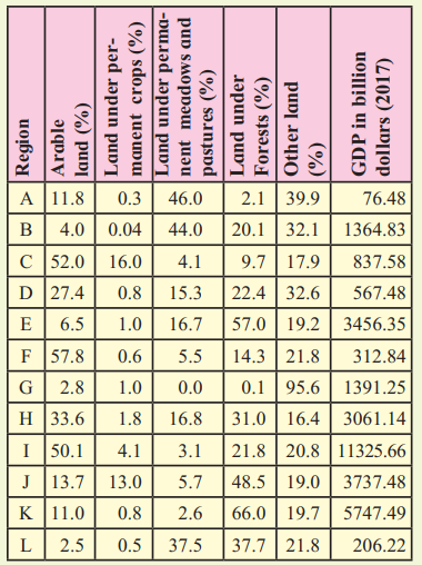
Answer:
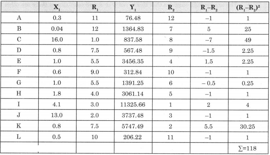
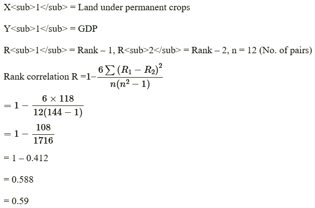

The answer of correction between (1) Land under permanent crops (2) GDP is 0.59 or +0.59 which means there is a positive correlation between these two variables.
It is not perfect positive correlation (+1.0). It is slightly less than this i.e. (+0.59).
It means when the amount of land under permanent crops is more, GDP is also more and when the amount of land under permanent crops is less, GDP is also less.
This is because the production of crops contributes to the growth of GDP.
The answer 0.59 suggests that this is not true for all countries as there are other factors, activities, products which are responsible for the growth of GDP other than the production of crops.
Leave a Reply