eVidyarthi
Menu
  • School
    • Close
    • CBSE English Medium
    • CBSE Hindi Medium
    • UP Board
    • Bihar Board
    • Maharashtra Board
    • MP Board
    • Close
  • Sarkari Exam Preparation
    • Close
    • Notes For Competitive Exams
    • MCQs for Competitive Exams
    • All Govt Exams Preparation
    • NCERT Syllabus for Competitive Exam
    • Close
  • Study Abroad
    • Close
    • Study in Australia
    • Study in Canada
    • Study in UK
    • Study in Germany
    • Study in USA
    • Close
Geography Class 8 Maharashtra Board | Menu
  • MCQ Geography Class 8 Maharashtra Board
  • Question Answer Geography Class 8 Maharashtra Board
  • Notes Geography Class 8 Maharashtra Board
  • Important Questions Geography Class 8 Maharashtra Board
  • Book Geography Class 8 Maharashtra Board
  • Geography Class 8

Notes Class 8 Chapter 10 Geography Maharashtra Board

Notes For All Chapters – Geography Class 8

Field Visit


1. Introduction to Field Trip

  • A field trip is an important method of studying geography.
  • It provides firsthand experience of geographical factors and processes.
  • Field trips help students understand the relationship between humans and the environment.
  • The main objective is to visit an office or place to understand the work done there.
  • Planning the trip according to the topic, place, and duration is essential.
  • Information collected during the trip helps in better understanding of the subject.
  • After collecting the information, a report is prepared based on the findings.

2. Importance of Field Trip

  • Helps students understand geographical concepts practically.
  • Provides real-life experience about environmental and social factors.
  • Enhances observation and analytical skills.
  • Encourages teamwork and problem-solving.
  • Improves report-writing and communication skills.

3. Preparations for the Field Trip

Before going for a field trip, proper preparations should be made:

  • Prepare a copy of the questionnaire.
  • Carry a notebook, camera, pen, and pencil.
  • Take prior permission from the concerned office before fixing the date and time.
  • Maintain discipline and take care not to damage anything during the trip.
  • Understand the objective of the visit and prepare accordingly.

4. Objectives of the Field Trip

  • To understand the functioning of an office.
  • To study the work processes involved.
  • To collect data for preparing a report.
  • To observe and analyze the geographical and administrative setup.

5. Report Writing

After collecting information from the office, a detailed report must be prepared based on the following structure:

(1) Introduction

  • Mention the objective of the visit.
  • Provide background information about the office.

(2) Personnel Working in the Office

  • Describe the staff and their designations.
  • Mention the key roles and responsibilities.

(3) Nature of Work in the Office

  • Explain the work process.
  • Highlight the importance of the work done in the office.

(4) Problems Encountered and Solutions

  • Mention any difficulties faced during the visit.
  • Suggest possible solutions.

(5) Acknowledgement

  • Thank the office staff for their cooperation.
  • Acknowledge the guidance of teachers and officials.

(6) List of References

  • Include sources of information and research material.

6. Example of a Field Trip

  • Students from a school made a field trip to the Tehsildar’s office.
  • They prepared a questionnaire and collected information about the election process.
  • After meeting the Chief Electoral Officer, they compiled the data and prepared a report.
  • The report helped them understand the election process and its significance.

7. Importance of Election Office Visit

  • Helps students understand the democratic process.
  • Provides knowledge about the role of election officials.
  • Creates awareness about the importance of voting and fair elections.
  • Encourages students to become responsible citizens.

8. Efforts to Make the Process Transparent

  • Use of VVPAT (Voter Verified Paper Audit Trail) for verification.
  • CCTV cameras and independent observers.
  • Proper training for election officials to avoid errors.

9. Advantages and Disadvantages of Voting Machines (EVM)

Advantages:

  • Quick counting of votes.
  • Accuracy and reduced chances of invalid votes.
  • Saves time and resources.

Disadvantages:

  • Risk of malfunctioning.
  • Doubts about transparency and tampering.

10. Code of Conduct

  • The Code of Conduct is applicable for around 45 days before and after elections.
  • Ensures a fair and unbiased environment during elections.
  • Regulates the behavior of political parties and candidates.

Important Questions Class 8 Chapter 10 Geography Maharashtra Board

Imp Questions For All Chapters – Geography Class 8

Field Visit


Short Questions

1. What is the main objective of a field trip?

  • To understand the kind of work done at a specific place.

2. Why are field trips important in geography?

  • They provide firsthand experience of geographical factors and processes.

3. What must be carried during a field trip?

  • A questionnaire, notebook, pen, pencil, and camera.

4. What kind of information is collected during a field trip?

  • Information about the work done at the office.

5. Why is it necessary to take permission before a field trip?

  • To avoid any inconvenience during the visit.

6. What is the purpose of a questionnaire during a field trip?

  • To gather structured information about the visit.

7. Who should students meet during an election office visit?

  • The Chief Electoral Officer.

8. What should be done after collecting information?

  • Compile it into a report.

9. How should the report be presented?

  • Individually or in a group.

10. What tools can be used to make the report more effective?

  • Maps, tables, graphs, pictures, and photographs.

Long Questions

1. Why is it important to plan a field trip according to the topic, place, and duration?

  • Planning ensures that the field trip is well-organized, and students can gather relevant information effectively. It helps avoid confusion and ensures proper time management.

2. What precautions should be taken during a field trip to an election office?

  • Students should avoid damaging office property, behave respectfully, and follow all the rules. Taking permission beforehand is essential for a smooth visit.

3. How can a questionnaire help students during a field trip?

  • A questionnaire provides a structured way to gather important details. It ensures that no important question or topic is missed during the visit.

4. What are the benefits of collecting information firsthand during a field trip?

  • Firsthand information helps students understand real-life processes better. It improves their observation and analytical skills.

5. Why is it necessary to meet the Chief Electoral Officer during an election office visit?

  • The Chief Electoral Officer is responsible for overseeing the election process. Meeting them helps students understand the functioning of the election office.

6. How can students make their field trip report more effective and engaging?

  • Including graphs, tables, and photographs makes the report visually appealing. It also helps in better understanding and presentation of the data collected.

7. What challenges can be faced during a field trip, and how can they be solved?

  • Lack of coordination, unclear instructions, and insufficient data can be challenges. Proper planning and teamwork can help solve these issues.

8. Why is it important to understand the work carried out at an election office?

  • It helps students learn about the democratic process, voter registration, and election management. This knowledge builds awareness and responsibility.

9. What kind of licenses are issued by the election office during elections?

  • Licenses for political rallies, loudspeakers, and public meetings are issued. This ensures proper regulation and order during the election process.

10. How can a field trip to an election office help students in understanding elections?

  • It helps students understand the voting process, election rules, and the role of different officials. It also creates awareness about the importance of voting.

Questions Answers Class 8 Chapter 10 Geography Maharashtra Board

Questions Answers For All Chapters – Geography Class 8

Solutions

Field Visit


Questionnaire :

Visit to the elections division’s office at the taluka and district level:

(1) Name of the office.

Answer: Election Division Office at the Taluka/District level.

(2) What is the designation of the chief at this office?

Answer: Chief Electoral Officer (CEO) or District Election Officer (DEO).

(3) What are the different duties performed by this office?

Answer: Voter registration, updating electoral rolls, conducting elections, voter awareness, handling election-related complaints, and counting votes.

(4) Who directs the work carried out in the election division?

Answer: The Chief Electoral Officer (CEO) or District Election Officer (DEO).

(5) Which are the various elections conducted through this office?

Answer: Lok Sabha (Parliamentary), Vidhan Sabha (State Assembly), Panchayat, Municipal, and by-elections.

(6) From where do they get the additional manpower required during election?

Answer: Government staff, teachers, and other government employees.

(7) How many days prior to election is the notice given?

Answer: Typically 30-45 days before the election.

(8) Who does the work of enlisting new voters and updating the electoral lists?

Answer: Booth Level Officers (BLO) and other appointed officials.

(9) Who conducts the training programmes for the elections?

Answer: Conducted by the Election Commission through the CEO’s office.

(10) Which are the licenses issued by the office during elections?

Answer: Permits for rallies, loudspeakers, and political advertisements.

(11) How many people are appointed at the polling centre during voting?

Answer: Presiding Officer, Polling Officers, and security personnel.

(12) When is the voting of officials appointed for election duty taken? How?

Answer: Before the general public voting, through postal ballots or special voting centers.

(13) What are the timings of the voting?

Answer: Usually from 7:00 a.m. to 6:00 p.m.

(14) Is the timing of voting extended under special circumstances?

Answer: Yes, under special circumstances like technical issues or high voter turnout.

(15) What efforts are taken to make the process of voting transparent?

Answer: Use of VVPAT machines, independent observers, and CCTV monitoring.

(16) Tell the advantages /disadvantages of voting machine. (EVM)

Answer:

  • Advantages: Fast counting, accuracy, reduced chances of invalid votes.
  • Disadvantages: Technical malfunctions, mistrust among voters.

(17) How are voting machines obtained?

Answer: From the Election Commission.

(18) Since when are the voting machines being used?

Answer: EVMs have been used since the early 2000s.

(19) What action needs to be taken if the voting machine becomes faulty?

Answer: Replacement by a standby machine and recording of issues.

(20) How was voting conducted earlier?

Answer: Paper ballots.

(21) The Code of Conduct is applicable for how many days before and after the elections?

Answer: Usually 45 days before and a few days after elections.

(22) Which departments do you seek help from to conduct the elections?

Answer: Police, local administration, revenue department, and health department.

(23) In which circumstances are by-elections held?

Answer: Held when a seat becomes vacant due to resignation, death, or disqualification.

(24) What do you do if the candidates get equal votes?

Answer: Decision through a lottery system or re-election.

(25) Who declares the end result of the election in the public?

Answer: Chief Electoral Officer or District Election Officer.

(26) Does the office maintain records of the earlier elections?

Answer: Yes, records of previous elections are maintained.

(27) Do you issue certificates to the elected candidates? Who signs these certificates?

Answer: Issued by the Election Officer and signed by the Chief Electoral Officer.

Notes Class 8 Chapter 9 Geography Maharashtra Board

Notes For All Chapters – Geography Class 8

Map Scale


Introduction to Map Scale

  • A map is a reduced representation of the earth or a part of it on a flat surface.
  • It is not possible to represent real-world distances directly on paper; they need to be reduced in proportion.
  • A map scale helps to represent these real-world distances in a manageable size.
  • A map scale indicates the relationship between the distance on a map and the actual distance on the ground.

Example:

  • If the scale of a map is 1 cm = 10 km, it means that 1 cm on the map represents 10 km in reality.

Why is a Map Scale Necessary?

  1. Helps in measuring real-world distances accurately.
  2. Assists in navigation and travel planning.
  3. Enables comparison of distances between different locations.
  4. Helps in understanding the size and shape of geographical features.
  5. Ensures that maps can be drawn consistently for different purposes.

How a Map is Made

  1. First, a survey is conducted to measure the actual distances on the ground.
  2. A suitable scale is chosen based on the level of detail required.
  3. The map is drawn according to this fixed scale.
  4. After the map is completed, the scale is mentioned for easy reference.

Types of Map Scales

There are three main types of map scales used in cartography:

1. Verbal Scale (Statement Scale)

  • The scale is expressed using words to describe the ratio between the map distance and ground distance.
  • Example:“1 cm = 60 km” → 1 cm on the map equals 60 km on the ground.

Advantages:

  • Easy to understand and use.
  • Does not require any mathematical conversion.

Disadvantages:

  • Difficult to use for accurate calculations.
  • Becomes inaccurate if the map is resized.

2. Numerical Scale (Representative Fraction or RF)

  • The scale is represented as a ratio between map distance and ground distance using the same unit.
  • Example: 1 : 60,00,000 → 1 unit on the map represents 60,00,000 units on the ground.

Advantages:

  • Can be easily converted into other units.
  • Used worldwide, so it’s easy to compare different maps.

Disadvantages:

  • No direct indication of units used.
  • Requires calculation to interpret real distances.

Conversion Examples:

  • 1 : 60,00,000 = 1 cm = 60 km
  • 1 : 1,00,000 = 1 cm = 1 km

3. Linear Scale (Graphical Scale)

  • A line or bar is drawn on the map, divided into equal segments representing real distances.
  • You can measure distances directly using a ruler.

Advantages:

  • Remains accurate even if the map is resized.
  • Easy to use for measuring curved distances with string or thread.

Disadvantages:

  • Requires a ruler or measuring tool.

Example: A linear scale divided into segments where:1 cm = 5 km0 cm → 5 km → 10 km → 15 km


Importance of Graphical Scale

  • If a map is resized (enlarged or reduced), the graphical scale will adjust proportionally.
  • Numerical and verbal scales may become inaccurate when the map size changes.
  • That’s why graphical scales are commonly used in atlases and wall maps.

Large Scale and Small Scale Maps

1. Large Scale Maps

  • Covers a small area with more detail.
  • Generally used for city maps, village maps, and property maps.
  • Scale is smaller than 1 : 10,000.

Examples:

  • 1:5,000 → Large Scale
  • 1:1,000 → Large Scale

2. Small Scale Maps

  • Covers a large area with less detail.
  • Used for country maps, world maps, and atlas maps.
  • Scale is larger than 1 : 50,000.

Examples:

  • 1:1,00,000 → Small Scale
  • 1:10,00,000 → Small Scale

Measurement of Distances on a Map

  1. Measure the distance between two points on the map using a ruler or string.
  2. Refer to the scale on the map.
  3. Convert the measured distance using the map scale.

Example:

  • Scale: 1 cm = 10 km
  • Distance on the map = 5 cmActual distance = 5 × 10 km = 50 km

Measuring Curved Distances

  • Use a thread or piece of paper to trace the curve.
  • Measure the length of the thread.
  • Apply the map scale to find the actual distance.

Conversion of Scales

1. Verbal to Numerical Scale

Example: “1 cm = 53 km”

  • Convert to numerical scale:1 cm / 53 km = 1 : 5,300,000

2. Numerical to Verbal Scale

Example: 1 : 10,000,000

  • 1 cm on the map represents 100 km on the ground.

Use of Different Types of Scales

Type of ScaleUse CasesExamples
Verbal ScaleSimple maps for travel guidesRoad maps
Numerical ScaleScientific and professional mapsGeological maps
Graphical ScaleWall maps and atlasesPolitical and physical maps

Important Questions Class 8 Chapter 9 Geography Maharashtra Board

Imp Questions For All Chapters – Geography Class 8

Map Scale


Short Questions

1. What is a verbal scale in maps?

  • A verbal scale expresses the map distance using words, such as “1 cm = 60 km.”

2. What is the ratio used to express a numerical scale?

  • A numerical scale is written as a ratio, e.g., 1:60,00,000.

3. What does a large-scale map represent?

  • A large-scale map shows a small area in greater detail.

4. Give one example of a small-scale map.

  • A world map is an example of a small-scale map.

5. What is the function of a graphical scale in maps?

  • A graphical scale shows distance using a line marked with measurements.

6. What happens to the graphical scale when a map is resized?

  • The graphical scale adjusts with the map size.

7. What is the actual distance if the numerical scale is 1:1,00,000 and map distance is 2 cm?

  • The actual distance is 2 km (2 × 1,00,000 ÷ 100,000).

8. How is the height of students reduced in a photograph similar to a map scale?

  • Both follow the principle of proportionate reduction.

9. What is the importance of a map scale?

  • It helps convert map distances to real-world distances.

10. Why is a numerical scale considered a global scale?

  • It is independent of measurement units and works universally.

Long Questions

1. Explain why a painter holds a pencil while drawing a landscape.

  • A painter holds a pencil to estimate the scale of the landscape, which helps in creating an accurate sketch similar to how scales are used in maps.

2. What are the three methods of expressing a map scale?

  • Map scales can be expressed verbally (e.g., 1 cm = 60 km), numerically (e.g., 1:60,00,000), and graphically using a line marked with distances.

3. How is a large-scale map different from a small-scale map?

  • A large-scale map covers a small area in detail, while a small-scale map covers a large area with less detail.

4. Why is a graphical scale more useful than a verbal or numerical scale?

  • A graphical scale adjusts automatically when the map is resized, making it more adaptable for different formats.

5. How does the concept of map scale apply to photographs of students?

  • Just like map scales, the height of students in a photograph reduces proportionally, maintaining the same ratio.

6. What happens if a numerical scale is not mentioned on a map?

  • Without a numerical scale, it becomes difficult to accurately calculate the actual ground distance from the map.

7. Explain how surveying helps in creating accurate maps.

  • Surveying measures actual ground distances, which are then converted to map distances using a scale.

8. Why is a numerical scale independent of units of measurement?

  • A numerical scale is based on ratios, so it remains consistent regardless of whether the unit is meters or miles.

9. How does a map scale help in understanding travel distances?

  • A map scale allows calculation of actual distances, helping travelers estimate travel time and cost.

10. Why are most atlas maps considered small-scale maps?

  • Atlas maps cover large areas with less detail, fitting more geographical information into a smaller space.

Questions Answers Class 8 Chapter 9 Geography Maharashtra Board

Questions Answers For All Chapters – Geography Class 8

Solutions

Map Scale


Q. (1) (a) Classify maps showing the following areas into small scale or large scale

(1) Building
(2) School
(3) Country of India
(4) Church
(5) Mall
(6) World Map
(7) Garden
(8) Dispensary
(9) Maharashtra State
(10) The north sky at night

Answer: Large Scale Maps

1. Building
2. School
3. Church
4. Mall
5. Garden
6. Dispensary

Small Scale Maps

6. World Map
9. Maharashtra State
10. The north sky at night

(b) There are two maps with respective scales of 1cm=100m and 1cm=100km. Give a well reasoned answer as to which of them would be a large scale map and which a small scale map. Recognize the type of maps.

Answer:

(b) Identification of large and small scale maps:

  • 1 cm = 100 m → Large Scale Map
    • This is a large scale map because it shows more detailed information of a smaller area.
  • 1 cm = 100 km → Small Scale Map
    • This is a small scale map because it covers a larger area with less detail.

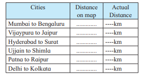
Q. (2) Using a map of India from the atlas measure straight line distance between the following cities and complete the table below.

questions-2

Answer: City Distances Table

CitiesDistance on mapActual Distance
Mumbai to Bengaluru……………984 km
Vijayapura to Jaipur……………1,260 km
Hyderabad to Surat……………966 km
Ujjain to Shimla……………1,050 km
Patna to Raipur……………750 km
Delhi to Kolkata……………1,500 km

Q. (3) (a) The distance between two points A and B on the Ground is 500m. Show this distance on paper by a line of 2cm. Express the map scale by any one method and mention it.

Answer:

  • Distance on the ground = 500 m
  • Distance on paper = 2 cm

Scale = Distance on paper / Distance on ground

2 cm500 m = 2 cm50000 cm\frac{2 \, \text{cm}}{50000 \, \text{cm}}

= 1 : 25,000

The map scale is 1 : 25,000 (Numerical Scale).

(b) Convert verbal scale of 1cm=53km to a numerical scale

Answer:

1 cm = 53 km = 5,300,000 cm
Numerical scale = 1 : 5,300,000

(c) Convert the numerical scale of 1:10,000 000 to a verbal scale in the metric system

Answer:

1 : 10,000,000 means 1 cm on the map = 10,000,000 cm on the ground 10,000,000 cm = 100 km
Verbal scale = 1 cm = 100 km


Q (4) Help them, using road and railway maps of the state of Maharashtra. Use the scale given in the maps.

(a) Ajay wants to arrange a family trip. Beed-Aurangabad-Dhule-Nasik Mumbai-Pune-Solapur-Beed. He wants to visit tourist places along this route.The cost of the vehicle is Rs 12/- per km. What would be the approximate cost of travel?

Answer: Approximate cost of Ajay’s trip:

  1. Beed → Aurangabad → Dhule → Nasik → Mumbai → Pune → Solapur → Beed
  2. Total distance (approx.) = 1,200 km
  3. Vehicle cost per km = Rs 12/-

Cost = 1200 × 12 = Rs 14,400

➡️ Approximate cost of travel = Rs 14,400

(b) Saloni has been asked to organize a trip by her teacher. She has selected Nagpur-Chandrapur-Nanded-Washim-Akola Malkapur. What would be the total coverage in kilometers?

Answer: Total distance for Saloni’s trip:

  1. Nagpur → Chandrapur → Nanded → Washim → Akola → Malkapur
  2. Total distance = 800 km

➡️ Total coverage = 800 km

(c) Vishawasrao is transporting goods in a vehicle from Alibag (district Raigad) to Naldurg (district – Osmanabad).How many km. will he be covering aproximately for a to and fro travel?

Answer: Distance for Vishwasrao’s trip:

  1. Alibag → Naldurg = 500 km (one way)
  2. To and fro distance = 500 × 2 = 1000 km

➡️ Total distance = 1000 km

Notes Class 8 Chapter 8 Geography Maharashtra Board

Notes For All Chapters – Geography Class 8

Industries


1. Introduction to Industries

  • Industries refer to the process of converting raw materials into finished products in factories.
  • The finished product is more durable, useful, and valuable than raw materials.
  • Industries provide secondary occupation and contribute to the economic development of a country.
  • Development of industries boosts economic growth and improves the standard of living.

2. Types of Industries

Industries are classified based on various factors:

(a) Agro-Based Industries

  • Industries that depend on agricultural products for raw materials.
  • Examples:
    • Dairy industry – Milk and milk-based products.
    • Fruit processing – Juices, jams, and pickles.
    • Food processing – Canned and packaged foods.
    • Sugar industry – Sugar production from sugarcane.

(b) Mineral-Based Industries

  • Industries that use minerals as raw materials.
  • Examples:
    • Iron and Steel Industry – Uses iron ore and coal.
    • Aluminium Industry – Uses bauxite.

(c) Forest-Based Industries

  • Industries that use forest products as raw materials.
  • Examples:
    • Paper Industry – Uses wood pulp.
    • Furniture Industry – Uses timber and wood.

(d) Small-Scale Industries

  • Require less capital investment.
  • Employ a small workforce.
  • Examples:
    • Handicrafts
    • Book binding
    • Toy making

(e) Large-Scale Industries

  • Require large capital investment.
  • Employ a large workforce.
  • Examples:
    • Textile Industry
    • Automobile Industry
    • Oil Refineries

(f) IT-Based Industries

  • Work related to data processing and software development.
  • Examples:
    • Software development
    • Data analysis
    • Web development

3. Factors Affecting Industrial Development

The following factors affect the growth and location of industries:

(a) Availability of Raw Material

  • Industries are located near sources of raw materials to reduce transportation costs.
  • Example: The iron and steel industry in Jamshedpur is located near iron ore mines.

(b) Labour

  • Availability of skilled and unskilled labour is essential for efficient production.

(c) Capital

  • Industries require capital investment for infrastructure, machinery, and raw materials.

(d) Transport and Communication

  • Efficient transport and communication systems help in the easy movement of raw materials and finished products.

(e) Water and Power Supply

  • Water is required for processing, cooling, and cleaning.
  • Uninterrupted electricity supply ensures smooth production.

(f) Market

  • Proximity to markets reduces transportation costs and ensures higher profits.

4. Maharashtra Industrial Development Corporation (MIDC)

  • Established on 1st August 1962 by the Maharashtra government.
  • Aimed at decentralizing industries across Maharashtra.
  • Provides facilities such as:
    • Water and electricity at concessional rates.
    • Tax benefits.
    • Infrastructure development.
  • Encouraged the growth of auxiliary industries.
  • Generated employment opportunities for local people.

5. Importance of Industrial Development

  • Boosts economic growth by increasing national income.
  • Creates employment opportunities.
  • Increases per capita income.
  • Promotes exports and increases foreign exchange reserves.
  • Improves the standard of living.

6. Information Technology (IT) Industry

  • IT industry is based on data processing, software development, and internet-based services.
  • India has made rapid progress due to the availability of skilled manpower.
  • IT services include:
    • Software development
    • Data analysis
    • Web development
    • Communication technology
  • Major IT hubs in India:
    • Bengaluru
    • Hyderabad
    • Noida
    • Pune

7. Corporate Social Responsibility (CSR)

  • When industries work for the betterment of society, it is called Corporate Social Responsibility (CSR).
  • Industries earning more than ₹5 crores annually are required to spend 2% of their profits on CSR activities.
  • CSR areas include:
    • Education – Establishing schools and training centres.
    • Health – Providing medical facilities and health camps.
    • Environment – Tree plantation, pollution control, and waste management.
    • Community Development – Village development, building infrastructure.

8. Industrialization and the Environment

Industrial development has both positive and negative effects on the environment:

Positive Effects:

  • Employment opportunities
  • Increased standard of living
  • Improved infrastructure

Negative Effects:

  • Air and water pollution
  • Noise pollution
  • Deforestation
  • Soil erosion

Solutions to Control Pollution:

  • Proper disposal of industrial waste.
  • Recycling and reusing waste.
  • Installation of pollution control equipment.
  • Promoting eco-friendly production methods.

9. Advantages and Disadvantages of Industrialization

Advantages:

  • Increases income and wealth.
  • Creates direct and indirect employment.
  • Improves infrastructure and technology.

Disadvantages:

  • Causes pollution and environmental damage.
  • Increases urbanization and overcrowding.
  • Leads to unequal regional development.

10. Industrial Pollution and Environmental Laws

  • Industrial pollution includes:
    • Air pollution
    • Water pollution
    • Noise pollution
    • Soil pollution
  • Environmental Protection Laws:
    • Water and Air Pollution Control Act
    • Environmental Protection Act
  • Central Pollution Control Board – Monitors pollution levels and enforces regulations.

11. Solutions to Environmental Issues

  • Use of renewable energy sources.
  • Efficient waste management.
  • Promoting green technology and eco-friendly production.
  • Reducing emissions through better manufacturing techniques.

Important Questions Class 8 Chapter 8 Geography Maharashtra Board

Imp Questions For All Chapters – Geography Class 8

Industries


Short Questions

1. What is the main aim of industrial development?

  • To increase employment and improve economic growth.

2. Name one factor essential for the growth of industries.

  • Availability of raw materials.

3. What type of industry is the sugar industry?

  • Agro-based industry.

4. When was Maharashtra Industrial Development Corporation (MIDC) established?

  • On 1st August 1962.

5. What is the minimum profit required for an industry to follow CSR rules?

  • 5 crores.

6. What is the role of transport in industrial development?

  • It helps in the easy movement of raw materials and finished goods.

7. Name one major IT centre in India.

  • Bengaluru.

8. What does CSR stand for?

  • Corporate Social Responsibility.

9. What is the main disadvantage of industrialization?

  • Pollution.

10. Why is Jamshedpur ideal for the iron and steel industry?

  • Availability of raw materials and energy sources nearby.

Long Questions

1. How does industrial development help improve the economy of a country?

  • Industrial development creates job opportunities, increases per capita income, boosts exports, and strengthens the country’s foreign exchange reserves.

2. Why is the availability of raw material important for industries?

  • Industries require raw materials for production, and having them nearby reduces transportation costs and improves efficiency.

3. Explain the role of Maharashtra Industrial Development Corporation (MIDC).

  • MIDC was established to decentralize industries across Maharashtra, provide infrastructure, and create employment opportunities.

4. What is the importance of the IT industry in India’s economy?

  • The IT industry provides high-paying jobs, strengthens the service sector, and increases foreign exchange through software exports.

5. How do industries contribute to pollution?

  • Industrial processes release harmful waste into the air, water, and land, causing environmental degradation and health issues.

6. Why are skilled workers important for industrial growth?

  • Skilled workers improve production quality and efficiency, leading to better products and increased profitability.

7. What is the objective of Corporate Social Responsibility (CSR)?

  • CSR aims to support education, health, and environmental development, improving the overall quality of life in society.

8. Why is transport essential for industrial development?

  • Efficient transport reduces production costs by enabling easy movement of raw materials and finished goods.

9. What role does water play in the development of industries?

  • Water is essential for processing, cleaning, and cooling in many industrial processes.

10. How does industrialization lead to urbanization?

  • Industries attract people from rural areas in search of jobs, leading to the growth of cities and infrastructure development.

Questions Answers Class 8 Chapter 8 Geography Maharashtra Board

Questions Answers For All Chapters – Geography Class 8

Solutions

Industries


Q. 1. Mark ✓ in the box next to the right alternative

(A) Which factor amongst those mentioned below does not directly impact industrial development?

(i) Water
(ii) Electricity
(iii) Labor
(iv) Air

Answer: (iv) Air – Air does not directly impact industrial development.

(B) Which of the following is a small industry?

(i) Machine parts
(ii) Book binding industry
(iii) Silk Industry
(iv) Sugar industry

Answer: (ii) Book binding industry – Book binding industry is a small industry.

(C) Which of the following cities is not an IT Centre?

(i) Old Delhi
(ii) New Delhi
(iii) Noida
(iv) Bengaluru

Answer: (i) Old Delhi – Old Delhi is not an IT Centre.

(D) An amount of 2% of the profits have to be utilized for which purpose by industries?

(i) Income Tax
(ii) Corporate Social Responsibility
(iii) Goods and Service Tax
(iv) Sales Tax

Answer: (ii) Corporate Social Responsibility – Industries must spend 2% of their profits on CSR if their profit exceeds 5 crores.


Q. 2. State whether the following statements are true or false. Correct the incorrect Statements.

(a) Small and medium industries of a country are harmful to heavy industries.

Answer: (a) False – Small and medium industries support heavy industries by providing necessary components and services.

(b) The level of industrialization is an indicator of the economic development of a country.

Answer: (b) True – The level of industrialization is an indicator of a country’s economic development.

(c) The aim of the industrial development corporations is to decentralize industrialization.

Answer: (c) True – The aim of industrial development corporations is to decentralize industrialization.

(d) Corporate social responsibility is compulsory for every industrialist.

Answer: (d) False – Corporate social responsibility is compulsory only for industries making profits above 5 crores.


Q. 3. Answer the following questions in three to four lines.

(a) What are the facilities provided by the government to industrial estates?

Answer:

The government provides the following facilities to industrial estates:

  • Concessional rates for electricity, water, and taxes.
  • Infrastructure like roads, drainage systems, and communication facilities.
  • Assistance with land acquisition and licensing.

(b) Write in your own words how industrial development impacts national development.

Answer:

Industrial development improves national development by:

  • Increasing employment opportunities.
  • Boosting exports and foreign exchange reserves.
  • Improving the standard of living and per capita income.

(c) Give your opinion in short on the usefulness of Corporate Social Responsibility.

Answer:

Corporate Social Responsibility (CSR) is useful because:

  • It improves the quality of life of the community.
  • It supports education, health, and environmental development.
  • Industries get tax rebates for CSR contributions.

(d) Mention three features of small industries.

Answer:

Three features of small industries are:

  • Require less capital investment.
  • Employ a small workforce.
  • Often dependent on local resources.

Q. 4. Write detailed answers to the following questions.

(a) Explain the factors affecting industrial development.

Answer:

Factors affecting industrial development:

  • Raw Material – Availability of raw materials is crucial.
  • Water and Electricity – Essential for manufacturing processes.
  • Labour – Availability of skilled and unskilled labour.
  • Transport and Market – Proximity to markets and transport facilities reduces costs.
  • Capital – Financial investment and availability of loans are important.

(b) State the advantages of the Maharashtra Industrial Development Corporation.

Answer:

Advantages of Maharashtra Industrial Development Corporation (MIDC):

  • Established to decentralize industries across Maharashtra.
  • Provides infrastructure and essential facilities.
  • Promotes employment opportunities for local people.
  • Encourages the growth of auxiliary industries.

(c) Explain the importance of the I. T. Industry.

Answer:

Importance of the IT Industry:

  • IT industry involves processing, analyzing, and presenting information using computers.
  • India has a skilled workforce, contributing to its rapid growth.
  • The development of software and data analysis has made India a global IT hub.

(d) Considering India’s population, the development of industries is a good solution to the problem of unemployment Explain.

Answer:

Development of industries as a solution to unemployment:

  • Provides direct and indirect employment.
  • Supports the growth of small and medium enterprises.
  • Increases the standard of living and economic development.
  • Reduces migration from rural areas to urban areas.

Q. 5. Prepare a flow chart for the following statements.

(a) The journey of clothes we use from the farm to ourselves.

Answer: 1.Cotton farming → 2. Harvesting → 3. Processing → 4. Weaving → 5. Dyeing → 6. Stitching → 7. Distribution → 8. Selling → 9. Wearing

(b) Essential factors for the location of any one industry.

Answer: 1. Raw material availability → 2. Water and electricity supply → 3. Labour availability → 4. Transport facilities → 5. Market proximity → 6. Capital availability


Q. 6. Highlight the differences.

(a) Medium industries – heavy industries

Answer:

Medium IndustriesHeavy Industries
Require moderate investmentRequire large capital investment
Produce consumer goodsProduce capital goods
Employ moderate workforceEmploy large workforce

(b) Agro based industries – Information Technology industries.

Answer:

Agro-Based IndustriesInformation Technology Industries
Depend on agricultural productsDepend on data and technology
Examples: Dairy, sugar, food processingExamples: Software, data analysis
Use natural resourcesUse human resources and technology

Notes Class 8 Chapter 7 Geography Maharashtra Board

Notes For All Chapters – Geography Class 8

Population


1. Introduction to Population

  • Population refers to the total number of people living in a particular area.
  • It can be measured at different levels:
    • Village
    • Taluka (administrative division)
    • District
    • State
    • Nation
    • World
  • Population is a key factor for the development of a region.
  • Aspects to consider while studying population:
    • Population growth
    • Population density
    • Population distribution
    • Structure of population

2. Population Growth

Population growth refers to the increase or decrease in the number of people in a region over time. It is influenced by:

(a) Birth Rate

  • The number of live births per 1,000 people in a year.
  • Higher birth rate = increase in population.

(b) Death Rate

  • The number of deaths per 1,000 people in a year.
  • Higher death rate = decrease in population.

(c) Life Expectancy

  • The average lifespan expected for an individual at the time of birth.
  • Longer life expectancy = higher population growth.

(d) Migration

  • The movement of individuals or groups from one place to another.
  • In-migration – People moving into a region increases population.
  • Out-migration – People moving out of a region decreases population.

Natural population change = Birth rate − Death rate Total population change = Natural population change + Net migration


3. Population Distribution

Population distribution refers to how people are spread across a region. It depends on:

  • Geographical factors – Climate, terrain, availability of water, etc.
  • Economic factors – Job opportunities, industrial development, etc.
  • Social and political factors – Peace, security, social acceptance, etc.

Dense population: Areas with abundant resources and favorable conditions.
Sparse population: Regions with poor soil, harsh climate, or limited resources.


4. Population Density

Population density measures how crowded a place is.
Formula:

Population Density=Total Population/Total Area (sq. km)​

  • High population density – Example: Kerala, Mumbai
  • Low population density – Example: Rajasthan, Gadchiroli

5. Structure of Population

The structure of the population is studied by dividing the population into different categories:

(a) Age Structure

  • Young (below 15 years) – Dependent on productive population.
  • Productive age group (15 to 59 years) – Active in economic activities.
  • Old age group (60 years and above) – Dependent but provide experience.

(b) Sex Ratio

  • Ratio of females to males in a population.
  • Formula:


Sex Ratio=Number of FemalesNumber of Males×1000\text{Sex Ratio} = \frac{\text{Number of Females}}{\text{Number of Males}} \times 1000

Sex Ratio=Number of MalesNumber of Females​×1000

  • Balanced sex ratio = Indicator of a stable population.
  • High sex ratio – Example: Kerala (more females due to male out-migration).
  • Low sex ratio – Example: Haryana (lower number of females due to preference for male children).

(c) Literacy

  • A person is considered literate if they can read and write.
  • Higher literacy = Higher quality of life and better economic development.
  • Literacy rate is higher in urban areas compared to rural areas.

6. Occupational Structure

Population is classified based on occupation:

  • Primary occupation – Farming, fishing, mining (mostly rural areas).
  • Secondary occupation – Manufacturing, construction (mostly urban areas).
  • Tertiary occupation – Services like banking, education, healthcare (mostly urban areas).

7. Migration

Migration refers to the movement of people from one place to another:

  • Internal Migration – Movement within a country.
  • International Migration – Movement between countries.
  • Reasons for Migration:
    • Job opportunities
    • Education
    • Natural disasters
    • Political or social instability
  • Impact of Migration:
    • Increased pressure on resources in receiving areas.
    • Shortage of labor in regions with out-migration.

8. Human Development Index (HDI)

HDI measures the overall development of a country or region:

  • Economic parameter – Standard of living.
  • Health parameter – Life expectancy.
  • Education parameter – Average years of schooling.
  • HDI values range from 0 to 1:
    • Higher value = Higher development
    • Lower value = Lower development
  • Developed countries = HDI value close to 1
  • Developing countries = HDI value between 0.5 and 0.7

9. Population as a Resource

  • Population is an important resource for the development of a region.
  • Factors affecting the quality of population:
    • Health and nutrition
    • Education
    • Skills and employment opportunities
  • High quality population = Higher economic and social development.

10. Census

  • Population data is collected through a census.
  • Census in India is conducted every 10 years.
  • Last census conducted in 2011 – Population of India was 121 crores.

Advantages and Disadvantages of High and Low Population

FactorHigh PopulationLow Population
Resource UseHigh demand, overuse of resourcesUnderutilization of resources
Job OpportunitiesHigh competition for jobsLess competition, but fewer opportunities
InfrastructureOverburdened infrastructurePoorly developed infrastructure
Healthcare & EducationInsufficient facilitiesEasier access to facilities

Problems in High and Low Population Density Areas

ProblemHigh Density AreasLow Density Areas
HousingShortage of space, high rentsAbandoned houses, poor maintenance
HealthcareOvercrowded hospitalsLack of medical facilities
EducationOvercrowded schoolsFewer schools, long travel distances
EmploymentHigh competition for jobsFewer jobs available


Ads

HSC Maharashtra – Marathi Medium – Maharashtra Board

📘 Maharashtra Board Exam Resources (Marathi Medium)

  • Maharashtra Board Question Banks (Marathi)
  • Maharashtra Board Sample Papers in Marathi Medium
  • Previous Year Question Papers – Marathi Medium
  • Marathi Notes and Practice Mock Tests for SSC/HSC
  • Includes MCQs (Multiple Choice Questions) in Marathi
  • All resources are available in Marathi Medium

📗 Maharashtra Board Textbooks & PDFs (Marathi Medium)

  • 10th Standard Textbook PDF in Marathi
  • Class-wise Textbook PDF (Marathi Medium)
  • Marathi Digest in PDF
  • SSC/HSC Class Books in Marathi PDF
  • Downloadable PDFs - Marathi Education Board

📒 Marathi Study Material for Maharashtra Board

  • Notes in Marathi
  • Chapter-wise Question & Answer (Solutions) in Marathi
  • Important Questions for SSC – Marathi Medium
  • Summary Important Formulas
  • MCQ's, Question Bank, Sample Papers, Previous Year Paper for cxlass 6th to 12th Std for Maharstra Board

क्लास की बुक (पुस्तक), MCQ, नोट्स इन हिंदी

Download एनसीईआरटी सलूशन, सैंपल पेपर, प्रश्न पत्र इन पीडीएफ

CBSE, उत्तर प्रदेश, मध्य प्रदेश, बिहार, राजस्थान & हरियाणा Board हिंदी माध्यम

कक्षा 6 to 8 हिंदी माध्यम
कक्षा 9 & 10 हिंदी माध्यम
कक्षा 11 हिंदी माध्यम

State Board

यूपी बोर्ड 6,7 & 8
बिहार बोर्ड हिंदी माध्यम

CBSE Board

Mathematics Class 6
Science Class 6
Social Science Class 6
हिन्दी Class 6
सामाजिक विज्ञान कक्षा 6
विज्ञान कक्षा 6

Mathematics Class 7
Science Class 7
SST Class 7
सामाजिक विज्ञान कक्षा 7
हिन्दी Class 7

Mathematics Class 8
Science Class 8
Social Science Class 8
हिन्दी Class 8

Mathematics Class 9
Science Class 9
English Class 9

Mathematics Class 10
SST Class 10
English Class 10

Mathematics Class XI
Chemistry Class XI
Accountancy Class 11

Accountancy Class 12
Mathematics Class 12

Learn English
English Through हिन्दी
Job Interview Skills
English Grammar
हिंदी व्याकरण - Vyakaran
Microsoft Word
Microsoft PowerPoint
Adobe PhotoShop
Adobe Illustrator
Learn German
Learn French
IIT JEE

Study Abroad

Study in Australia: Australia is known for its vibrant student life and world-class education in fields like engineering, business, health sciences, and arts. Major student hubs include Sydney, Melbourne, and Brisbane. Top universities: University of Sydney, University of Melbourne, ANU, UNSW.

Study in Canada: Canada offers affordable education, a multicultural environment, and work opportunities for international students. Top universities: University of Toronto, UBC, McGill, University of Alberta.

Study in the UK: The UK boasts prestigious universities and a wide range of courses. Students benefit from rich cultural experiences and a strong alumni network. Top universities: Oxford, Cambridge, Imperial College, LSE.

Study in Germany: Germany offers high-quality education, especially in engineering and technology, with many low-cost or tuition-free programs. Top universities: LMU Munich, TUM, University of Heidelberg.

Study in the USA: The USA has a diverse educational system with many research opportunities and career advancement options. Top universities: Harvard, MIT, Stanford, UC Berkeley

Privacy Policies, Terms and Conditions, Contact Us
eVidyarthi and its licensors. All Rights Reserved.