eVidyarthi

Main Menu
  • eVidyarthi
  • School
    • Class 6th
      • Maths Class 6
      • Science Class 6
      • Hindi Class 6
      • Vyakaran
      • English Class 6
      • English Grammar
      • Sanskrit Class 6
      • Geography Class 6
      • Civics Class 6
      • History Class 6
    • Class 7th
      • Maths Class 7
      • Science Class 7
      • Hindi Class 7
      • Vyakaran
      • English Class 7
      • English Grammar
      • Sanskrit Class 7
      • Geography Class 7
      • Civics Class 7
      • History Class 7
    • Class 8th
      • Maths Class 8
      • Science Class 8
      • Hindi Class 8
      • Vyakaran
      • English Class 8
      • English Grammar
      • Sanskrit Class 8
      • Geography Class 8
      • Civics Class 8
      • History Class 8
    • Class 9th
      • Maths Class 9
      • Science Class 9
      • Hindi Class 9
      • व्याकरण
      • English Class 9
      • English Grammar
      • Economics Class 9
      • Geography Class 9
      • Civics Class 9
      • History Class 9
      • Sanskrit Class 9
    • Class 10th
      • Maths Class 10
      • Science Class 10
      • Hindi Class 10
      • Vyakaran
      • English Class 10
      • English Grammar
      • Economics Class 10
      • Geography Class 10
      • Civics Class 10
      • History Class 10
      • Sanskrit Class 10
    • Class 11
      • Maths Class 11
      • English Class 11
      • Hindi Class 11
      • Accounts Class 11
      • Physics Class 11
      • Chemistry Class 11
      • Biology Class 11
      • Economics Class 11
      • Geography Class 11
      • History Class 11
      • Political Science Class 11
      • Sociology Class 11
    • Class 12
      • Maths Class 12
      • English Class 12
      • Hindi Class 12
      • Accounts Class 12
      • Physics Class 12
      • Chemistry Class 12
      • Biology Class 12
      • Economics Class 12
      • Geography Class 12
      • History Class 12
      • Political Science Class 12
      • Sociology Class 12
    • Close
  • School – हिन्दी माध्यम
    • Class 6
      • Hindi Class 6
      • English Grammar
      • Vyakaran
      • Ganit Class 6
      • Vigyan Class 6
      • Samajik Vigyan Class 6
      • English Class 6
      • संस्कृत Class 6
    • Class 7
      • Hindi Class 7
      • English Grammar
      • Vyakaran
      • गणित Class 7
      • विज्ञान Class 7
      • सामाजिक विज्ञान Class 7
      • English Class 7
      • Sanskrit Class 7
    • Class 8
      • Hindi Class 8
      • English Grammar
      • Vyakaran
      • गणित Class 8
      • विज्ञान Class 8
      • सामाजिक विज्ञान Class 8
      • English Class 8
      • Sanskrit Class 8
    • Class 9
      • Hindi Class 9
      • English Grammar
      • Vyakaran
      • गणित Class 9
      • विज्ञान Class 9
      • सामाजिक विज्ञान Class 9
      • English Class 9
      • Sanskrit Class 9
    • Class 10
      • Hindi Class 10
      • English Grammar
      • Vyakaran
      • गणित Class 10
      • विज्ञान Class 10
      • सामाजिक विज्ञान Class 10
      • English Class 10
      • Sanskrit Class 10
    • Class 11
      • गणित Class 11
      • English Class 11
      • Hindi Class 11
      • अर्थशास्त्र Class 11
      • भूगोल Class 11
      • इतिहास Class 11
      • राजनितिक विज्ञान
      • समाजशास्त्र Class 11
      • भौतिक विज्ञान Class 11
      • रसायन विज्ञान Class 11
      • जीव विज्ञान Class 11
    • Class 12
      • गणित Class 12
      • English Class 12
      • Hindi Class 12
      • अर्थशास्त्र Class 12
      • भूगोल Class 12
      • इतिहास Class 12
      • राजनितिक विज्ञान
      • समाजशास्त्र Class 12
      • भौतिक-विज्ञान Class 12
      • रसायन विज्ञान Class 12
      • जीव विज्ञान Class 12
    • Close
  • बिहार बोर्ड
    • Class 6
      • हिंदी Class 6
      • Vyakaran
      • English Grammar
      • गणित Class 6
      • विज्ञान Class 6
      • English Class 6
      • सामाजिक विज्ञान Class 6
      • Sanskrit Class 6
    • Class 7
      • हिंदी Class 7
      • Vyakaran
      • English Grammar
      • गणित Class 7
      • विज्ञान Class 7
      • English Class 7
      • सामाजिक विज्ञान Class 7
      • Sanskrit Class 7
    • Class 8
      • हिंदी Class 8
      • Vyakaran
      • English Grammar
      • गणित Class 8
      • विज्ञान Class 8
      • English Class 8
      • सामाजिक विज्ञान Class 8
      • Sanskrit Class 8
    • Class 9
      • हिंदी Class 9
      • Vyakaran
      • English Grammar
      • गणित Class 9
      • विज्ञान Class 9
      • English Class 9
      • सामाजिक विज्ञान Class 9
      • Sanskrit Class 9
    • Class 10
      • हिंदी Class 10
      • Vyakaran
      • English Grammar
      • गणित Class 10
      • विज्ञान Class 10
      • English Class 10
      • सामाजिक विज्ञान Class 10
      • Sanskrit Class 10
    • Close
  • English
    • Basic English Grammar
    • Basic English Speaking
    • English Vocabulary
    • English Idioms & Phrases
    • Personality Enhancement
    • Interview Skills
    • Close
  • Softwares
    • Microsoft Word
    • PhotoShop
    • Excel
    • Illustrator
    • PowerPoint
    • Close
Class 9th Geography || Menu
  • MCQ Geography Class 9
  • Notes Geography Class 9
  • Sample Papers Geography Class 9
  • Book Geography Class 9
  • India – Size and Location
  • Physical Features of India
  • Drainage
  • Climate
  • Natural Vegetation and Wildlife
  • Population
  • Economics Class 9
  • Civics Class 9
  • History Class 9
Share on WhatsApp

India – Size and Location, Class 9 Geography NCERT Solutions

Ads

take-the-test

(i) Tropic of Cancer does not pass through

(a) Rajasthan
(b) Orissa
(c) Chhattisgarh
(d) Tripura

Answer : (b)

(ii) The easternmost longitude of India is

(a) 97° 25′ E
(b) 68° 7′ E
(c) 77° 6′ E
(d) 82° 32′ E

Answer : (a)

(iii) Uttarakhand, Uttar Pradesh, Bihar, West Bengal and Sikkim have common frontier with

(a) China
(b) Nepal
(c) Bhutan
(d) Myanmar

Answer : (c)

(iv) If you intended to visit Kavaratti during your summer vacations, which one of the following Union Territories of India will you be going to?

(a) Puducherry
(b) Lalcshadweep
(c) Bangladesh
(d) Nepal

Answer (b)

(v) My friend hails from a country which does not share land boundary with India. Identify the country.

(a) Bhutan
(b) Bangladesh
(c) Tajikistan
(d) Nepal

Answer (b)

Question 2.  Answer the following questions briefly.

(i) Name the group of islands lying in the Arabian Sea.

Answer : Lakshadweep Islands lie in the Arabian Sea.

(ii) Name the countries which are larger than India.

Answer : Russia, Canada, USA. China, Australia and Brazil are the countries that are larger than India.

(iii) Which island group of India lies to its South-East?

Answer : Andaman and Nicobar Islands lie to the South-East of India.

(iv) Which island countries are our Southern neighbours?

Answer : Sri Lanka and Maldives are the two island countries that are the Southern neighbours of India.

Question 3. The Sun rises two hours earlier in Arunachal Pradesh as compared to Gujarat in the West but the watches show the same time. How does this happen?

Answer : From Gujarat to Arunachal Pradesh there is a time lag of two hours, but the watches show the same time because the time along the Standard Meridian of India (82 0 30′ E) passing through Mirzapur in Uttar Pradesh is taken as the standard time for the whole country. Because the same standard time for the whole country has been adopted, the watches show the same time in Arunachal Pradesh and Gujarat and in all parts of the country.

Question 4. The central location of India at the head of the Indian Ocean is considered of great significance. Why?

Answer : The Indian landmass has a central location between East and West Asia. India is a southward extension of the Asian continent.

The trans Indian Ocean routes which connect the countries of Europe in the West to the countries of East Asia provide a strategic central location to India.

The Deccan peninsula protrudes into the Indian Ocean, thus helping India to establish close contact with West Asia, Africa and Europe from the Western coast and South-East and East Asia from the Eastern coast.

No other country has a long coastline on the Indian Ocean as India has.

Thus, India’s eminent position in the Indian Ocean Justifies the naming of an ocean after it.

Map Skills

Question 1. Identify the following with the help of map reading.

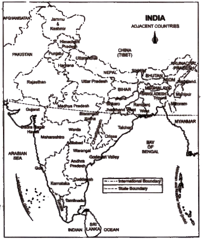
(i) The island groups of India lying in the Arabian Sea and the Bay of Bengal.

Answer : Lakshadweep Islands and Andaman and Nicobar Islands

(ii) The countries constituting the Indian Sub-continent.

Answer : Pakistan, Afghanistan, Nepal, Bhutan, Myanmar and Bangladesh.

(iii) The states through which the Tropic of Cancer passes.

Answer : Gujarat, Rajasthan, Madhya Pradesh, Chhattisgarh, Jharkhand, Paschim Banga, Tripura and Mizoram.

(iv) The northernmost latitude in degrees.

Answer : 37° 6’N

(v) The southernmost latitude of the Indian mainland in degrees.

Answer : 8° 4’N

(vi) The eastern and the Westernmost longitude in degrees.

Answer : 68° 7’E and 97° 25’E

(vii) The place situated on the three seas.

Answer : Kanyakumari

(viii)The straight separating Sri Lanka from India.

Answer : Palk Strait

(ix) The Union Territories of India.

Answer : Andaman and Nicobar Islands, Chandigarh, Dadra and Nagar Haveli, Daman and Diu, Lakshadweep, Puducherry and Delhi.

Project/Activity

(i) Find out the longitudinal and latitudinal extent of your state.

Answer : Do it yourself. Sample answeris given below

My state is Uttar Pradesh longitudinally it extends from 77°4’E to 84°39’E. Latitudinally it extends from about 30 0 20’N to about 23°53’N.

(ii) Collect information about the ‘Silk Route: Also find out the new developments which are improving communication routes in the regions of the high altitude.

Answer : (a) Do it yourself. It is given in your History book. Some information is given below

The Silk Road or Silk Route refers to a historical network of interlinking trade routes across the Afro-Eurasian landmass that connected East, South. and Western Asia with the Mediterranean and European world, as well as parts of North and East Africa.

The land routes were supplemented by sea routes, which extended from the Red Sea to coastal India, China and South-East Asia.

Extending 4,000 miles (6,500 km), the Silk Road gets its name from the lucrative Chinese silk trade along it. which began during the Han Dynasty (206 BCE – 220 CE). The central Asian sections of the trade routes were expanded around 114 BCE by the Han dynasty largely through the missions and explorations of Zhang Qian, but earlier trade routes across the continents already existed.

In the late Middle Ages. transcontinental trade over the land routes of the Silk Road declined as sea trade increased. In recent years, both the maritime and overland Silk Routes are again being used, often closely following the ancient routes.

(b) Communication routes in regions of high altitude are now-a-days through helicopter (for closer distances) and through high altitude railways like the Ouinghai railway in China linking Lhasa (capital of Tibet) with the rest of the world. More information can be found on this railway from the internet.

Ads

Android App

eVidyarthi

Evidyarthi on Facebook

Like us on Facebook

YouTube Channels

Social Science Class 6
Social Science Class 8
Learn English
English Through हिन्दी
Job Interview Skills
English Grammar
हिंदी व्याकरण - Vyakaran
Mathematics Class 6th
Social Science Class 6
Science Class 6th
हिन्दी Class 6th
Mathematics Class 7th
Science Class 7th
हिन्दी Class 7th
Mathematics Class 8th
Social Science Class 8
Science Class 8th
हिन्दी Class 8th
Mathematics Class 9th
English Class 9th
Science Class 9th
Mathematics Class 10th
English Class 10th
Mathematics Class XI
Chemistry Class XI
Accountancy Class 11th
Accountancy Class 12th
Mathematics Class 12th
Microsoft Word
Microsoft Excel
Microsoft PowerPoint
Adobe PhotoShop
Adobe Illustrator
Learn German
Learn French
IIT JEE
Privacy Policies, Contact Us
Copyright © 2022 eVidyarthi and its licensors. All Rights Reserved.