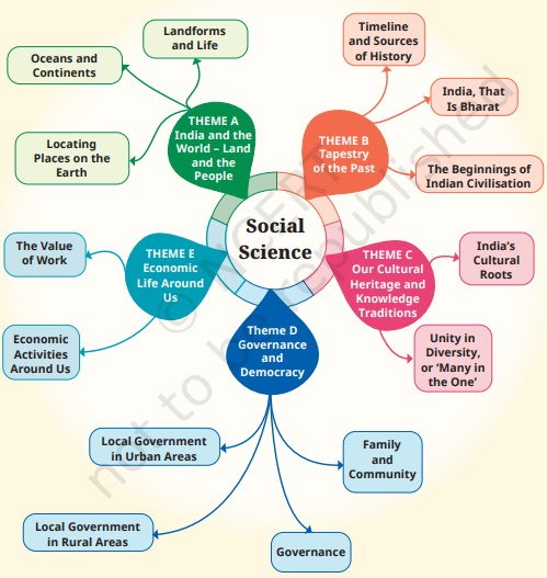
Notes For All Chapters – Social Science Class 6
Locating Places on the Earth
Introduction: Why Social Science?
Purpose of Social Science:
- Helps in understanding the complex and diverse nature of human societies.
- Aims to address fundamental questions about humanity, peace, harmony, and environmental sustainability.
Challenges in the 21st Century:
- Rapid technological progress and its impact on society.
- Growing conflicts, social tensions, and environmental stress.
Importance of Studying Social Science:
- Understanding our world and societies to find solutions for global challenges.
- Although not a ‘science’ like physics or chemistry, it uses scientific methods where possible.
Subdisciplines of Social Science:
- Includes geography, history, political science, economics, sociology, anthropology, archaeology, psychology, etc.
- In the Middle Stage, the focus is on five broad themes rather than these subdisciplines.
Themes in Social Science
1. Theme A – India and the World: Land and the People
- Focuses on geographical features and their influence on civilizations.
- Explores how natural settings contribute to the identity of civilizations, especially in India.
2. Theme B – Tapestry of the Past
- Explores history, understanding its connection to the present.
- Discusses the importance of learning from the past to avoid repeating mistakes.
3. Theme C – Our Cultural Heritage and Knowledge Traditions
- Examines India’s rich and ancient culture, its principles, and its manifestation in history.
- Aims to help students understand and appreciate cultural foundations.
4. Theme D – Governance and Democracy
- Focuses on understanding political systems, especially India’s democracy.
- Explores the functioning of government organs and the role of citizens in governance.
5. Theme E – Economic Life Around Us
- Discusses how economies work, focusing on India’s economy.
- Covers concepts like money, resources, and economic activities.
Locating Places on the Earth
A Map and Its Components
1. Definition of a Map:
- A map is a representation or drawing of an area, viewed from the top.
- It can represent:
- Small areas (e.g., a village or town).
- Bigger areas (e.g., a district or state).
- Large areas (e.g., an entire country or the world).
- Atlas: A collection of maps compiled into a book.
2. Types of Maps:
Physical Maps:
- Show natural features like mountains, rivers, and oceans.
- Example: A physical map of India showing its major rivers and mountain ranges.
Political Maps:
- Highlight boundaries of countries, states, and cities.
- Example: A political map of India showing all States, Union Territories, and their capitals.
Thematic Maps:
- Provide specific information on a particular theme or topic.
- Example: Maps showing population density or climate zones.
3. Important Components of Maps:
Distance (Scale):
- The scale helps to fit a large area onto a small piece of paper.
- Example: In a city map, 1 cm on the map might represent 500 meters on the ground.
- Map Scale Example: A map of India may use a scale where 2.5 cm on the map equals 500 kilometers on the ground.
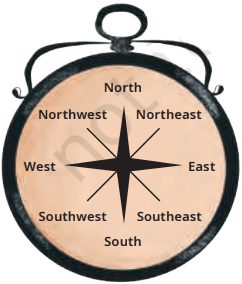
Direction (Cardinal Points):
- Cardinal Directions: North (N), East (E), South (S), West (W).
- Intermediate Directions: Northeast (NE), Southeast (SE), Southwest (SW), Northwest (NW).
- Example: The map may show the market north of the hospital, the museum southeast of the bank, etc.
- Most maps include an arrow marked ‘N’ to indicate the north direction.
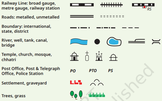
Symbols:
- Used to represent various features on the map due to space constraints.
- Symbols can denote:
- Buildings (e.g., a railway station, school, post office).
- Roads and Railway lines.
- Natural Elements (e.g., rivers, ponds, forests).
- Standard Symbols: The Survey of India provides a fixed set of symbols for Indian maps.
Mapping the Earth
1. Challenges in Mapping the Earth:
Shape of the Earth:
- Earth is nearly a sphere, but it is slightly flattened at the poles.
- Representing a spherical object accurately on a flat surface (like a map) is challenging.
- Example: Trying to flatten the peel of an orange without tearing it illustrates the difficulty in flattening a sphere.
Globe vs. Map:
- A globe is a spherical representation of the Earth or other celestial bodies (e.g., the Moon, Mars).
- A globe better represents Earth’s geography because it shares the same spherical shape.
2. Understanding Coordinates:
System of Coordinates:
- Used to determine the precise location of a place on Earth.
- Example 1: In a market, giving directions based on rows and shop numbers (e.g., “7th shop in the 5th row”).
- Example 2: Chessboard squares are identified by a combination of letters and numbers (e.g., d2 to d4).
3. Latitudes:
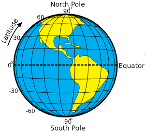
Definition: Latitudes are imaginary lines that run parallel to the Equator, measuring the distance north or south of it.
Key Features:
- The Equator is at 0° latitude.
- The North Pole is at 90° North latitude (90°N).
- The South Pole is at 90° South latitude (90°S).
Connection to Climate:
- Equator (Torrid Zone): Generally hot climate.
- Temperate Zones: Climate becomes moderate as you move away from the Equator.
- Frigid Zones: Closer to the poles, the climate grows colder.
4. Longitudes:
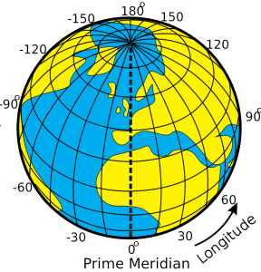
Definition: Longitudes are imaginary lines running from the North Pole to the South Pole, known as meridians.
Prime Meridian:
- The Prime Meridian (0° longitude) is the reference line for measuring longitudes.
- Also called the Greenwich Meridian because it passes through Greenwich, London, and was internationally adopted in 1884.
Measurement:
- Longitudes are measured in degrees, increasing westward or eastward from the Prime Meridian (0° to 180°).
- Example: New York is at 74°W, Delhi at 77°E, and Tokyo at 140°E.
Connection to Time:
- The Earth’s rotation causes different longitudes to experience different times (e.g., morning in one place, evening in another).
- Longitude can be used to measure the time of a place.
5. Latitude and Longitude Grid:
Grid System:
- Parallels of latitude and meridians of longitude together form a grid on the globe.
- This grid helps in locating any place on Earth using its coordinates.
- Example: Delhi is located at approximately 29°N latitude and 77°E longitude.
Understanding Time Zones
1. Earth’s Rotation and Time Calculation:
- Rotation: The Earth rotates from west to east, completing a full turn every 24 hours.
- Degrees per Hour: A full rotation is 360°, so the Earth rotates 15° per hour (360° ÷ 24 hours).
Longitude and Local Time:
- Moving eastward from the Prime Meridian (0°):
- 0° (Prime Meridian): 12 pm (noon)
- 15°E: 1 pm
- 30°E: 2 pm, and so on.
- Moving westward from the Prime Meridian:
- 15°W: 11 am
- 30°W: 10 am, and so on.
2. Standard Time:
Need for Standard Time:
- Using different local times within a country would be impractical.
- Most countries adopt a standard time based on a meridian passing through the country.
Indian Standard Time (IST):
- IST is 5 hours 30 minutes (5.5 hours) ahead of Greenwich Mean Time (GMT).
3. Time Zones:
- Definition: Time zones are regions of the Earth that have the same standard time.
- 15° Zones: Standard times are organized in zones that broadly follow 15° longitude increments.
World Map Considerations:
- The boundaries of time zones are not straight lines; they adjust to follow international borders.
- Positive and Negative Offsets: The numbers inside countries indicate the hours to be added to (positive) or subtracted from (negative) GMT to get their standard time.
4. The International Date Line:
- Location: Located approximately at 180° longitude, opposite the Prime Meridian.
- Function: Crossing the International Date Line changes the date by one day:
- Eastward Crossing: Subtract a day (e.g., Monday becomes Sunday).
- Westward Crossing: Add a day (e.g., Sunday becomes Monday).
- Deviation: The line deviates in places to avoid splitting countries into two different days.
5. Summary Points:
- Maps are essential tools to represent different areas of the Earth, using distance, direction, and symbols.
- Grid System: Every place on Earth can be precisely located using a grid of latitudes and longitudes.
- Longitude: Besides marking location, longitude also determines local time and defines time zones.
- International Date Line: Crossing this line results in a change of date by one day.

This is very helpful notes oooooooooo
please add sample paper and chapter wise test it will help a lot to us
VERY NICE APP
this notes is very helpful for me
thanks very much
very nice
Very nice 👍. But too long but support it too
Very good