1. Introduction to Oceans
Oceans cover most of our planet and play an important role in supporting life on Earth. They influence climate, provide food and energy, support marine life, and help people in trade, transport, fishing, and tourism.
In Indian culture, the ocean is commonly called Samudra and is considered powerful and sacred. It has an important place in traditional stories and rituals.
Importance of oceans
- Climate regulation: Ocean water movements influence temperatures and climate.
- Marine life: Oceans provide habitats for a wide variety of plants and animals.
- Food and livelihoods: Fishing and other marine activities provide food and employment.
- Transport and trade: Oceans connect countries through sea routes.
- Energy resources: Tides and waves can be used to generate electricity.
- Natural resources: Oceans contain oil, natural gas, minerals, and other valuable resources.
- Tourism: Beaches and coastal areas attract visitors.
- Communication: Undersea cables help connect different parts of the world.
Oceans are always in motion. Their movements include waves, tides, and currents, which influence the environment and human activities.
2. Ocean Relief
Meaning of ocean relief
Ocean relief, also known as submarine relief, refers to the different physical features found on the ocean floor.
Just as the land has mountains, valleys, plains, and plateaus, the ocean floor also contains mountains, slopes, flat plains, ridges, and deep trenches.
The ocean floor is not flat. It is a varied underwater landscape containing many important landforms.
Major features of ocean relief
1. Continental Shelf
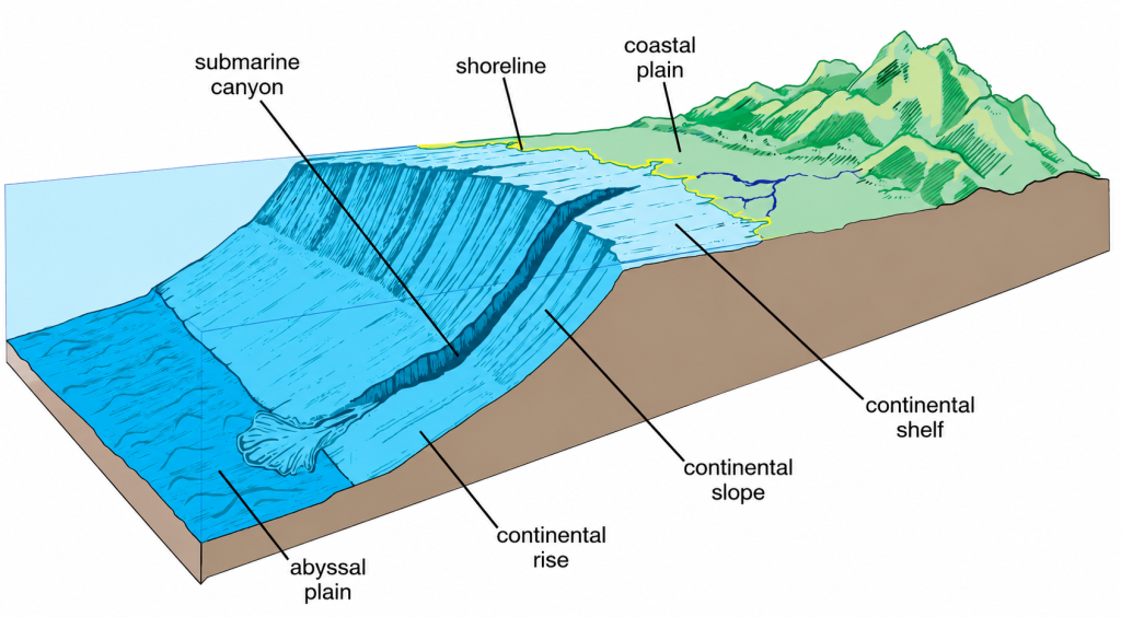
The continental shelf is the shallow, submerged edge of a continent that extends beneath the ocean.
- It is generally rich in marine life.
- It contains valuable resources such as oil and natural gas.
- It is important for fishing and the exploration of marine resources.
2. Continental Slope
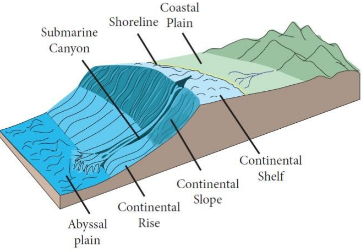
The continental slope is the steep slope that marks the true edge of a continent beneath the sea.
It connects the relatively shallow continental shelf with the deeper parts of the ocean floor.
3. Abyssal Plain
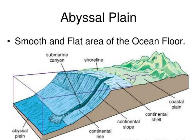
An abyssal plain is a vast, flat, and deep area of the ocean floor.
It forms an important part of the deep-ocean landscape.
4. Mid-Ocean Ridge
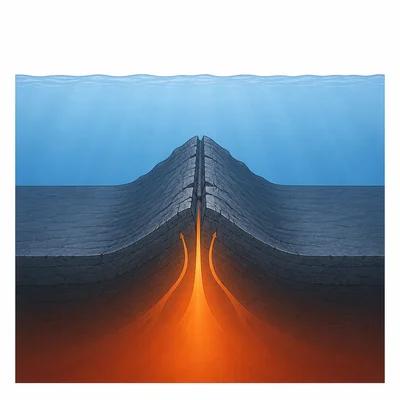
A mid-ocean ridge is an immense underwater mountain range formed by volcanic activity.
It is the world’s longest mountain range, although most of it lies beneath the ocean.
5. Ocean Trenches
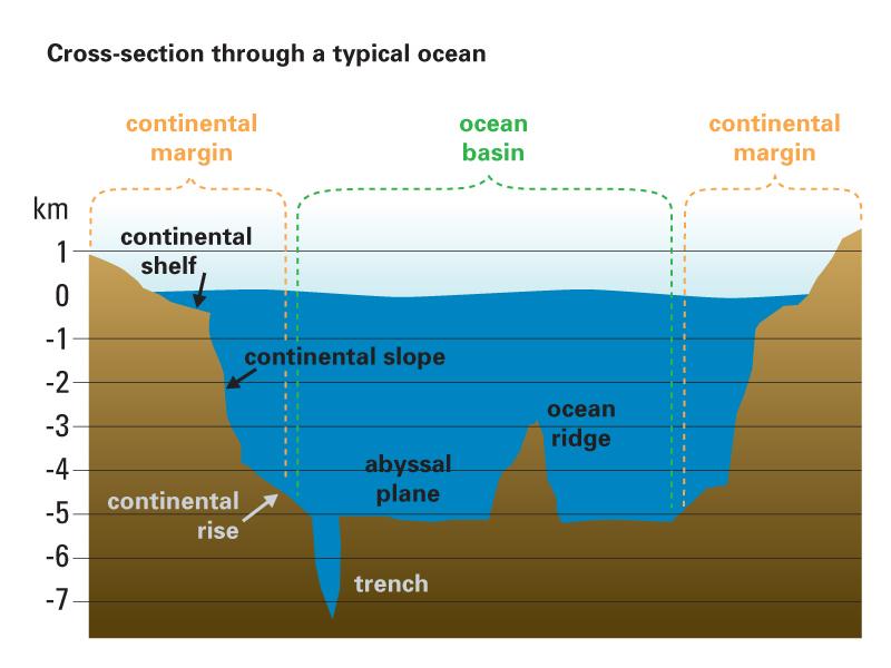
Ocean trenches are the deepest parts of the ocean floor.
The Mariana Trench in the Pacific Ocean is the deepest place on Earth.
6. Seamount
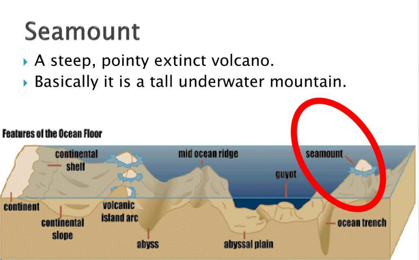
A seamount is an underwater mountain, usually of volcanic origin, that rises from the ocean floor but does not reach the sea surface.
7. Guyot
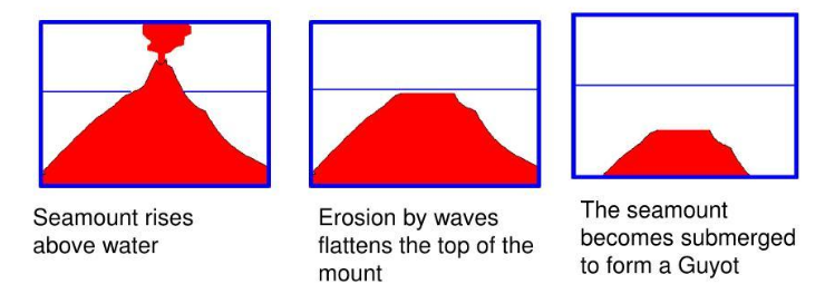
A guyot is a flat-topped underwater mountain. It is usually a former seamount whose summit was eroded by wave action over a long period and later submerged.
Other submarine features
- Submarine canyon: A deep valley-like feature on the ocean floor.
- Submarine hill: A small elevation rising above the surrounding ocean floor.
- Volcanic island: An island formed through volcanic activity that reaches above the sea surface.
- Rift valley: A valley associated with the separation of parts of the ocean floor.
Importance of ocean relief
- The continental shelf supports marine life and contains resources such as oil and natural gas.
- Underwater mountains, plains, and trenches create different environments for marine organisms.
- Ocean-floor features are important for underwater exploration.
- Knowledge of the ocean floor helps us understand the availability of marine resources and the physical structure of the oceans.
Important facts to remember
- Deepest place on Earth: Mariana Trench.
- World’s longest mountain range: Mid-Ocean Ridge.
- Mauna Kea in Hawai‘i is an underwater mountain whose total height is greater than Mount Everest when measured from its base on the ocean floor.
3. Movement of Ocean Water: Waves, Tides and Currents
Ocean water is constantly moving. The three major forms of ocean-water movement are waves, tides, and currents.
These movements shape coastlines, support marine life, influence climate, and help people in fishing and navigation.
A. Waves
Meaning of waves
A wave is the alternate rise and fall of the ocean surface. Waves are primarily caused by winds blowing across the water.
Waves carry energy over long distances across the oceans.
Important parts of a wave
- Crest The highest point of a wave.
- Trough The lowest point of a wave.
- Wavelength The horizontal distance between two consecutive wave crests or two consecutive troughs.
- Wave height The vertical distance between the crest and the trough.
- Wave period The time required for a wave crest to travel from one point to another.
- Wave frequency The number of wave crests passing a particular point each second.
How waves shape the coastline
Waves are called coastal architects because they change the shape of coastlines through erosion and the transport of sediments.
Two major processes are involved:
- Erosion: Waves wear away and remove rock and soil from the coast.
- Deposition: Waves deposit materials such as sand along the coast, forming features such as beaches.
Erosional landforms formed by waves
- Crack: A large opening develops in coastal rock due to the force of waves.
- Sea cave: The crack becomes wider and deeper through hydraulic action and abrasion.
- Sea arch: Continued erosion cuts through the back of a cave, forming an arch.
- Sea stack: The roof of an arch collapses, leaving a tall, isolated column of rock.
- Stump: A sea stack is further eroded and weathered, leaving a shorter rock remnant.
- Blowhole: A hole formed when erosion along a crack or cave extends upwards to the rock surface.
Hydraulic action
Hydraulic action is the erosion of rock and soil caused by the force of moving water, which loosens and removes material.
Tsunamis
Tsunamis are giant waves mainly caused by underwater earthquakes. They can be extremely destructive when they reach the coast.
During storms, strong winds can also generate huge waves that damage coastal areas. Tsunamis are different from ordinary wind-generated waves because they are primarily associated with disturbances such as underwater earthquakes.
When a tsunami reaches the shore, its maximum vertical height above sea level is called its run-up height. In extreme cases, it can reach 30 metres or even more.
B. Tides
Meaning of tides
Tides are the rhythmic rise and fall of ocean water, which occur twice a day in most parts of the world.
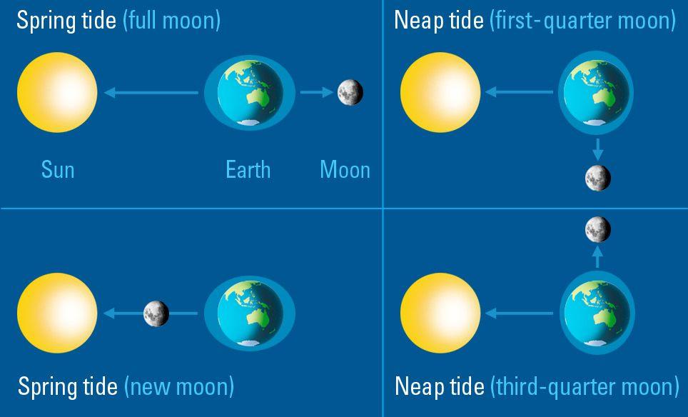
Tides are caused by gravitational forces, particularly those of the Moon and the Sun.
Types of tides
1. Spring tides
Spring tides occur when the Sun, Earth, and Moon are aligned in a straight line. This happens during the full moon and new moon phases.
- The combined gravitational pull of the Sun and Moon produces unusually high high tides.
- Low tides become unusually low.
- The difference between high and low tide is greater than during neap tides.
Difference between spring tides and neap tides
| Basis | Spring Tides | Neap Tides |
|---|---|---|
| Position of celestial bodies | Sun, Earth, and Moon are aligned. | The Sun and Moon act in different directions relative to Earth. |
| Lunar phases | Full moon and new moon. | First-quarter and third-quarter moon. |
| High tide | Unusually high. | Lower than spring high tide. |
| Low tide | Unusually low. | Higher than spring low tide. |
| Tidal range | Greater. | Smaller. |
Importance of tides
1. Navigation and shipping
- High tides raise the water level near the shore, helping ships enter harbours more easily.
- Ships must check water depth and tidal range before docking.
- Large ships may wait for high tide to pass through shallow channels safely.
For example, some very large crude carriers passing through shallow areas of the Singapore Strait wait for suitable high tides to avoid running aground.
2. Fishing
- During high tide, many fish move closer to the shore in search of food and shelter.
- This can help fishing communities obtain a better catch.
3. Generation of electricity
The rise and fall of tidal water can be used to generate electricity. This is called tidal energy.
Major tidal-energy sites identified in India include:
- Gulf of Kutch
- Gulf of Khambhat
- Sundarbans
India has a coastline of 11,098.81 kilometres, but tidal energy is not yet widely used on a large scale.
4. Tidal currents
Tidal changes cause large volumes of water to flow in and out of coastal areas, generating strong tidal currents. These currents can reach speeds of 5–6 knots, or approximately 9–11 km/h.
Example: The Bhadkeshwar Mahadev Temple in Dwarka, Gujarat, can be reached along its stone pathway during low tide. The pathway becomes submerged during high tide.
C. Ocean Currents
Meaning of ocean currents
Ocean currents are continuous streams of water that flow across the ocean surface in definite directions.
They are important because they influence coastal temperatures, climate, marine life, and fishing.
Causes of ocean currents
The major factors responsible for ocean currents are:
- Winds: Winds push ocean water and help create currents.
- Earth’s rotation: The Coriolis force deflects moving objects from their straight path.
- Differences in temperature: Variations in water temperature influence the movement of ocean water.
- Differences in salinity: Differences in the salt content of water influence ocean-water movement.
- Shape of continents and ocean basins: Landmasses and the shape of ocean basins influence the direction of currents.
Types of ocean currents
1. Warm currents
Warm currents flow from warmer regions towards cooler regions. They can raise the temperatures of nearby coastal areas.
Example: Gulf Stream
- It originates in the Gulf of Mexico in the Atlantic Ocean.
- It flows towards Norway.
- It helps keep waters in the Norwegian region relatively warm.
- Sea ice does not form easily there despite the region’s high latitude.
2. Cold currents
Cold currents carry colder water and can lower the temperatures of nearby coastal areas.
Example: Labrador Current
- It flows along the east coast of Canada.
- It carries freezing water.
- It supports the formation of sea ice and icebergs, even at lower latitudes.
On maps, warm currents are usually represented in red and cold currents in blue.
Importance of ocean currents
- They influence the temperature of nearby coastal regions.
- They affect climate and environmental conditions.
- They influence marine ecosystems.
- They support fishing activities in certain regions.
Fishing grounds
The regions where warm and cold ocean currents meet are known as fishing grounds. These waters are rich in nutrients, which support a large variety of fish.
4. Quick Comparison: Waves, Tides and Currents
| Feature | Waves | Tides | Ocean Currents |
|---|---|---|---|
| Meaning | Alternate rise and fall of the ocean surface. | Rhythmic rise and fall of ocean water. | Continuous streams of water flowing in definite directions. |
| Main Causes | Winds. | Gravitational forces of the Moon and Sun. | Winds, Earth’s rotation, temperature, salinity, and ocean-basin shape. |
| Important Effects | Shape coastlines and transport sediments. | Support navigation, fishing, and tidal-energy generation. | Influence coastal temperatures, climate, and fishing grounds. |
5. Cyclones and Tsunamis — Early Warning Systems
A. Natural hazards of the oceans
Oceans and seas can give rise to natural hazards that threaten people, property, and the environment.
Cyclones
- A cyclone is a large rotating storm caused by atmospheric disturbances over warm ocean waters.
- Cyclones can cause strong winds, heavy rain, storm surges, and coastal flooding.
Tsunamis
A tsunami is a series of giant waves mainly caused by underwater earthquakes. Tsunamis can cause severe damage when they reach coastal areas.
What is an early warning system?
An Early Warning System (EWS) is a system that detects possible natural hazards, predicts their effects, and communicates timely warnings so that people can take protective action.
These systems help people evacuate dangerous areas and reduce the loss of human and animal lives.
B. Importance of early warning systems
- They help detect cyclones and tsunamis at an early stage.
- They provide information about possible hazards.
- They allow governments and communities to prepare for emergencies.
- They help coastal residents evacuate threatened areas.
- They reduce the loss of lives and damage to property.
- They support emergency response and disaster management.
For an early warning system to work effectively, monitoring must continue regularly and warnings must reach the public quickly.
C. Cyclone warning systems in India
India has Cyclone Warning Services and Marine Weather Services that monitor storms along its eastern and western coasts.
The country uses advanced technologies to predict cyclones at an early stage, helping reduce the loss of human and animal lives.
Important programmes and organisations
1. National Cyclone Risk Mitigation Project (NCRMP)
The Government of India launched the NCRMP to:
- Build cyclone shelters.
- Strengthen cyclone warning systems.
- Improve emergency response mechanisms.
- Support cyclone-prone States and Union Territories.
- Provide a Decision Support System (DSS) for disaster management authorities.
2. Indian National Centre for Ocean Information Services (INCOIS)
INCOIS works with the India Meteorological Department (IMD) on the Storm Surge Early Warning System (SSEWS).
The system aims to:
- Forecast storm surges caused by cyclones.
- Predict the extent of coastal inundation.
- Protect communities living in coastal areas.
3. Cyclone naming system
Cyclones in the North Indian Ocean are named sequentially from a list of 169 names submitted by 13 member countries, including India.
Naming helps people and authorities communicate clearly about a particular cyclone and improves public awareness.
Examples mentioned in the chapter include Biparjoy (2023) and Remal (2024).
D. GEMINI device and the safety of fishermen
GEMINI stands for GAGAN-Enabled Mariner’s Instrument for Navigation and Information.
It is a handheld device designed to improve the safety of fishermen at sea.
How GEMINI works
- The device receives data from the GAGAN satellite.
- It transfers information to fishermen’s mobile phones through Bluetooth.
- The INCOIS mobile application displays the information in nine regional languages.
- Fishermen receive useful information for making safer decisions at sea.
Information provided through GEMINI
- High-wave and strong-wind alerts.
- Cyclone and tsunami warnings.
- Potential fishing zone advisories.
- Ocean-current speeds.
- Bathymetry data.
- Risk-management information.
At present, the communication channel can transmit information up to 50 nautical miles into the sea. An upgraded system is expected to introduce two-way communication on a pilot basis and benefit fishermen travelling up to 300 nautical miles.
Under the Pradhan Mantri Matsya Sampada Yojana (PMMSY), the government provides financial support for GEMINI devices to improve the safety of coastal communities.
Bathymetry
Bathymetry is the study and mapping of the underwater topography of water bodies, including oceans, rivers, lakes, and streams.
E. The Indian Ocean Tsunami of 2004
On 26 December 2004, a devastating tsunami struck areas bordering the Indian Ocean.
- Around 2,30,000 people lost their lives.
- Many countries bordering the Indian Ocean suffered severe environmental damage.
- India was among the worst-affected countries.
- Tamil Nadu, Puducherry, Andhra Pradesh, Keralam, and the Andaman and Nicobar Islands suffered extensive damage.
- The disaster encouraged countries to establish effective tsunami warning systems and strengthen disaster management.
The experience of Simeulue Island in Indonesia also highlighted the importance of traditional knowledge. Local folklore passed down through generations helped residents recognise tsunami warning signs and respond quickly.
F. Indian Tsunami Early Warning Centre (ITEWC)
The Indian Tsunami Early Warning Centre plays an important role in detecting tsunami threats and communicating warnings.
India established a real-time network of tsunami detection buoys to detect, measure, and monitor tsunamis.
Four main stages of a tsunami early warning system
1 Detection
A network of seismic stations detects undersea earthquakes in real time.
2 Confirmation
Ocean Bottom Pressure Recorders (OBPRs) placed on the seafloor detect the passage of tsunami waves and help confirm the threat.
3 Tracking
Coastal tide gauges and radars monitor changes in sea level and track the arrival and movement of tsunami waves.
4 Warning
Alerts are sent through satellites to government agencies and directly to officials and the public through SMS and other communication channels.
How warnings reach people
- The ITEWC issues alerts to the Government of India.
- The government informs State governments and emergency response teams.
- Warnings are communicated through satellite-based networks, SMS, emails, and coastal display boards.
- Officials and communities use the information to take appropriate protective action.
Role of public awareness
Technology alone is not enough to save lives. People must understand warnings and know how to respond.
Public awareness and training programmes help officials and coastal communities recognise hazards, follow evacuation instructions, and prepare for emergencies.
Key point: Early detection, fast communication, public awareness, and timely action are all essential for reducing disaster-related losses.
6. Marine Resources and Their Significance
A. Meaning of marine resources
Marine resources are the materials, organisms, and features found in oceans that have intrinsic or economic value.
Oceans are vast storehouses of resources that support food security, employment, economic activities, and the environment.
Examples include fish, seafood, marine organisms, oil, natural gas, minerals, sand, gravel, tidal energy, wave energy, and coral reefs.
B. Classification of marine resources
Marine resources are broadly divided into two categories:
1. Marine Living Resources
These include living organisms and biological materials obtained from the sea.
- Fish: An important source of food and protein.
- Marine organisms: Different organisms living in the oceans.
- Bioactive natural products: Useful products obtained from marine biological sources.
- Submerged aquatic vegetation (SAV): Aquatic plants growing underwater.
- Marine biodiversity: The variety of marine life.
2. Marine Non-Living Resources
These include non-living materials and energy sources obtained from the oceans.
- Minerals: Valuable mineral resources found in marine areas.
- Sand and gravel: Materials used for various purposes.
- Oil and natural gas: Conventional energy resources obtained from offshore areas.
- Gas hydrates: A resource identified in the classification of marine resources.
- Offshore wind: Wind energy generated in offshore areas.
- Ocean energy: Energy from tides, waves, and currents.
- Ocean Thermal Energy Conversion (OTEC): A method of obtaining energy using differences in ocean-water temperatures.
- Tourism potential: Beaches and coastal ecosystems support tourism-related activities.
C. Types of marine fish based on location
The chapter distinguishes fish according to where they live in relation to the continental shelf and ocean.
| Type | Meaning |
|---|---|
| Coastal or Neritic Fish | Live within the continental shelf at depths of 0–200 metres. |
| Oceanic Fish | Live beyond the continental shelf at depths greater than 200 metres. |
The classification also identifies epipelagic fish, pelagic fish, demersal fish, benthopelagic fish, and benthic fish.
D. Significance of marine resources
1. Food and nutrition
- Fish are a major source of protein.
- Seafood supports food security.
- Marine organisms contribute to human needs.
2. Employment and livelihoods
Fishing and aquaculture support important industries and provide livelihoods to many people.
Coastal communities depend on marine resources for their income and daily needs.
3. Energy
Oceans provide conventional energy resources such as offshore oil and natural gas.
They also offer potential for renewable blue energy from tides, waves, currents, and offshore wind.
4. Minerals and materials
Oceans contain sand, gravel, and deep-sea minerals that have economic value.
5. Trade and transport
Sea routes are essential for international trade. The chapter states that about 90% of global trade by volume is carried by sea.
6. Tourism
Coastal tourism is an important economic activity. Beaches and marine environments attract visitors and support businesses and employment.
7. Environmental importance
Marine ecosystems support biodiversity and provide habitats for numerous plants and animals.
Healthy marine ecosystems are necessary for maintaining the balance of ocean life.
8. Cultural significance
Oceans also have cultural and traditional importance.
The sacred śhaṅkha (conch) and kapardikā (cowrie shells) are regarded as treasures associated with the mythological Samudra Manthana. Cowrie shells were once used as currency.
Thus, oceans are valuable not only economically and environmentally but also culturally.
7. Blue Economy and Sustainable Use of Oceans
A. Meaning of Blue Economy
The Blue Economy refers to the sustainable use of ocean resources to promote economic growth, improve livelihoods, and create jobs while preserving the health of marine ecosystems.
It aims to balance economic development with the protection of the oceans.
B. Importance of the Blue Economy
- Economic growth: Ocean-based industries contribute to economic development.
- Employment: Fishing, aquaculture, tourism, shipping, and related activities provide jobs.
- Improved livelihoods: Responsible use of marine resources supports coastal communities.
- Environmental protection: It encourages the conservation of marine ecosystems.
- Sustainable energy: It promotes the use of ocean energy, including tidal and wave energy.
- Resource conservation: It encourages the responsible use of fish, minerals, and other marine resources.
C. Blue Economy and Sustainable Development Goal 14
The Blue Economy is connected to the United Nations’ Sustainable Development Goal 14: Life Below Water.
Its key aims include:
- Reducing marine pollution.
- Protecting marine ecosystems.
- Addressing ocean acidification.
- Regulating fishing.
- Conserving marine areas.
- Eliminating harmful subsidies.
- Increasing economic benefits from the sustainable use of marine resources.
D. Sustainable use of marine resources
Marine resources must be used responsibly so that ocean ecosystems are not damaged.
Sustainable use involves balancing the needs of people with the protection of marine life.
Important principles include:
- Preventing marine pollution.
- Protecting marine habitats and biodiversity.
- Regulating fishing activities.
- Conserving marine areas.
- Using ocean resources responsibly.
- Supporting livelihoods without disturbing marine ecosystems.
Remember: The central idea of the Blue Economy is to achieve economic growth without sacrificing the health of the oceans.
8. Maritime Zones
A. Meaning of maritime zones
Maritime zones are different areas of the ocean defined by international law. They determine the rights and responsibilities of countries over ocean waters and marine resources.
These zones help countries regulate fishing, navigation, resource use, and other activities at sea.
The United Nations Convention on the Law of the Sea (UNCLOS) provides the international legal framework for defining maritime zones.
B. Important terms
1. Baseline: The reference line from which the distances of maritime zones are measured.
2. Nautical mile: A unit of measurement used in maritime and air navigation. One nautical mile equals exactly 1,852 metres.
3. Territorial sea: The sea area closest to a country over which it exercises sovereignty, subject to certain international rights.
4. Innocent passage: The right of foreign ships to pass through a country’s territorial waters under specified conditions.
5. Exclusive Economic Zone (EEZ): An area in which a coastal country has special rights to explore, use, and manage ocean resources.
6. High seas: International waters beyond the EEZs of countries that do not belong to any single country.
C. Major maritime zones
1. Territorial Sea — up to 12 nautical miles
The territorial sea is the sea area closest to a country’s coast. A country exercises sovereignty over this zone, subject to international law and the right of innocent passage.
The government can make laws relating to customs, immigration, and pollution control.
Distance: Up to 12 nautical miles from the baseline.
2. Contiguous Zone — up to 24 nautical miles
The contiguous zone extends from the baseline up to 24 nautical miles.
In this zone, the country has limited control over matters relating to customs, fiscal matters, and illegal immigration.
Distance: Up to 24 nautical miles from the baseline.
3. Exclusive Economic Zone (EEZ) — up to 200 nautical miles
The EEZ extends from the baseline up to 200 nautical miles.
A country has special rights to explore, exploit, conserve, and manage ocean resources such as fish, oil, and natural gas.
Ships from other countries can still pass through the EEZ peacefully. The country does not fully own or control all the waters in this zone.
Distance: Up to 200 nautical miles from the baseline.
4. High Seas
The high seas are the international waters beyond the EEZs of countries.
- They do not belong to any single country.
- They cover about 64% of the world’s oceans.
- They are considered part of the global commons.
- All countries enjoy equal rights to activities permitted under international law, including navigation, fishing, and laying undersea cables.
The laws of the flag state—the country in which a ship is registered—apply to ships on the high seas.
D. Innocent passage
Innocent passage allows foreign ships to pass through the territorial waters of a country as long as their passage does not threaten its peace, good order, or security.
Conditions include:
- Ships must generally move continuously through the waters.
- Stopping is permitted in emergencies or cases of breakdown.
- The right does not permit fishing, military operations, or other non-peaceful activities.
This principle allows peaceful navigation while respecting the coastal country’s security.
E. Importance of maritime zones
- They define the rights and responsibilities of coastal countries.
- They help regulate fishing and the use of marine resources.
- They provide a framework for navigation and trade.
- They help countries manage offshore resources such as oil and natural gas.
- They help prevent conflicts over ocean territories and resources.
- They support international cooperation in the use and protection of oceans.
F. Problems associated with the high seas
Although the high seas are important for international activities, they present several challenges.
- Overfishing: Excessive fishing can reduce fish populations.
- Illegal fishing: Fishing activities may take place unlawfully.
- Resource conflicts: Countries and other users may disagree over marine resources.
- Navigation and safety: Ensuring safety is more difficult without clear enforcement mechanisms.
- Livelihood impacts: Problems involving marine resources can affect people who depend on the sea for food and income.
International cooperation is necessary to address these challenges and ensure that the high seas are used responsibly.
9. International Maritime Rules and Regulations
A. Meaning of maritime law
Maritime law refers to international rules and agreements that regulate activities at sea.
These rules help ships operate safely, protect the marine environment, safeguard trade routes, and settle disputes between countries.
Just as traffic rules are necessary on roads, ships must follow rules to prevent accidents and collisions at sea.
B. Objectives of maritime regulations
International maritime regulations aim to:
- Ensure safe movement of ships.
- Prevent collisions and accidents.
- Protect the marine environment from pollution.
- Safeguard trade routes.
- Address issues such as piracy, terrorism, natural disasters, and accidents.
- Settle disputes between countries.
- Encourage fair and sustainable use of ocean resources.
C. Important maritime conventions
1. COLREGs
COLREGs stands for the Convention on the International Regulations for Preventing Collisions at Sea.
These rules act as the rules of the road for ships.
They include:
- Maintaining a proper lookout.
- Following rules about which side to pass on.
- Identifying give-way and stand-on vessels.
- Travelling at a safe speed.
- Using appropriate lights and sound signals.
- Displaying shapes that identify different types of vessels.
- Taking suitable action to prevent collisions.
Ships also use international signals and radio communication to share information and prevent accidents, particularly in crowded or hazardous waters.
2. MARPOL
MARPOL stands for the International Convention for the Prevention of Pollution from Ships.
Its main purpose is to reduce pollution caused by ships and protect the marine environment.
Ships must meet safety standards and are prohibited from polluting the seas.
3. UNCLOS
UNCLOS stands for the United Nations Convention on the Law of the Sea.
It provides the international legal framework for maritime zones and defines countries’ rights and responsibilities at sea.
It helps establish rules for the use of marine resources and provides a framework for resolving disputes involving ocean areas.
D. Importance of international maritime rules
International maritime regulations:
- Make oceans safer for ships, sailors, and coastal communities.
- Reduce accidents and collisions.
- Help prevent marine pollution.
- Protect marine life and resources.
- Promote peaceful cooperation between countries.
- Support international trade and travel.
- Help settle disputes involving marine boundaries and resources.
- Encourage the sustainable use of oceans.
Without these regulations, oceans could become more dangerous and chaotic, with greater pollution, accidents, collisions, and conflicts over resources.

Leave a Reply