Shaping of the Earth’s Surface
Questions and activities
1. What are the sources of energy that are required to cause movements associated with the internal forces of the Earth?
Answer: The internal forces of the Earth are powered by heat from the Earth’s core, mantle, and crust. This heat causes molten material in the mantle to rise while cooler material sinks, creating convection currents. These convection currents push and pull the tectonic plates, causing them to move and giving rise to internal forces such as earthquakes, volcanic eruptions, folding, and faulting.
2. Relate various physiographic divisions you have studied in the earlier grades with various endogenic forces responsible for their origin.
Answer:
- Fold mountains (like the Himalaya) are formed when two continental plates collide at a convergent boundary.
- Volcanoes and volcanic activity occur when an oceanic plate collides with a continental plate and sinks beneath it (also at a convergent boundary).
- Mid-ocean ridges are created at divergent boundaries, where plates move apart and magma rises to form new crust.
- Ocean basins and continents are shaped by the overall distribution and movement of tectonic plates.
3. Why and where do earthquakes occur frequently? Is it possible to predict earthquakes?
Answer: Earthquakes occur mainly along plate boundaries, where tectonic plates meet. They are frequent at convergent boundaries (where plates collide) and transform boundaries (where plates slide past each other, such as along the San Andreas Fault). Most earthquakes and volcanoes occur around the Pacific Ocean, in the region known as the Ring of Fire.
4. “Plate movements are responsible for the distribution of earthquakes and volcanoes.” Explain.
Answer: Plate tectonics plays a major role in shaping the Earth’s surface, and the movement of plates leads to the formation of mountains, valleys, ocean basins, volcanoes, and earthquakes. Most earthquakes and volcanoes occur along plate boundaries, especially around the Pacific Ocean, known as the Ring of Fire. At convergent boundaries, colliding plates cause volcanic activity and earthquakes; at divergent boundaries, magma rises to form new crust; and at transform boundaries, plates sliding past each other mainly cause earthquakes. This shows that the distribution of earthquakes and volcanoes closely follows the pattern of plate boundaries.
5. Draw and label a diagram of a meander and a delta.
Answer:
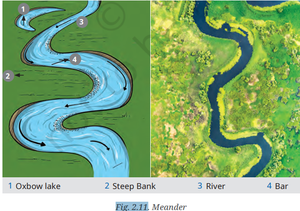
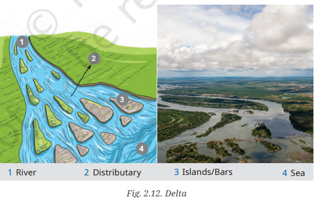
6. How are deforestation and erosion associated with each other? Explain.
Answer: Deforestation removes trees and plants whose roots normally hold soil together. Without this plant cover, erosion increases because there is nothing to bind the soil or slow down water and wind. The chapter notes that human activities such as deforestation disturb the natural balance of slopes, allowing excess water to accumulate, which leads to erosion and can trigger landslides. Similarly, sparse vegetation cover due to deforestation leaves the land exposed, making it more vulnerable to wind erosion and dust storms.
7. Develop a plan to protect the land in your local area from erosion.
Answer:
- Plant more trees and grasses.
- Avoid cutting forests unnecessarily.
- Build bunds and contour trenches on slopes.
- Use proper drainage systems.
- Spread awareness about soil conservation.
8. Which disasters do you think you might experience in your region? Discuss a mitigation plan in your classroom.
Answer:
- Earthquakes and dust storms may occur in my region.
- Follow disaster safety guidelines.
- Keep an emergency kit ready.
- Plant more trees to reduce dust.
- Stay alert and follow government warnings.
9. Prepare a model of landforms created by underground water.
Answer:
- Make a model showing a cave, stalactites, stalagmites, sinkhole, and underground river.
- Use clay, cardboard, and colours to label each landform clearly.
10. What precautionary measures will you take if you are staying in an earthquake-prone region?
Answer:
- Build earthquake-resistant houses.
- Keep an emergency kit ready.
- Stay away from windows during an earthquake.
- Take shelter under a strong table.
- Move to an open area after the shaking stops.
14. Translate the given poster on landslide into your native language and display it in your home.
Answer:
- Translate the landslide safety poster into your native language.
- Use simple and clear words.
- Display it at home to spread awareness.
15. Divide the class into three groups. Each group will work on one project (water, wind, and glacier). The project should highlight the causes, impact on human life and the environment, and mitigation measures.
Answer:
Group 1 (Water): Study water erosion, its effects, and methods to control it.
Group 2 (Wind): Study wind erosion, its effects, and prevention measures.
Group 3 (Glacier): Study glaciers, GLOFs, their impacts, and safety measures.
Present the findings using charts, models, or posters.
The Big Questions (page 13)
1. What shapes the Earth’s surface?
Answer: The Earth’s surface keeps changing due to forces working from inside and outside the planet. Internal forces like earthquakes, volcanic eruptions, folding, and faulting create mountains, valleys, and ocean basins. External forces like weathering, erosion, and deposition slowly break them down and reshape them. Together, these forces create all the different landforms we see today.
2. What is plate tectonics? What are the effects of plate movement?
Answer: Plate tectonics is a theory, given by W.J. Morgan, which explains that the Earth’s outer layer is broken into several large and small pieces called tectonic plates. These plates move slowly over the semi-molten layer beneath them. The movement of these plates causes the formation of mountains, valleys, ocean basins, volcanoes, and earthquakes. It also explains why continents and oceans are distributed the way they are. Most earthquakes and volcanoes happen along plate boundaries, especially around the Pacific Ocean, called the Ring of Fire.
3. How are landforms formed and how are they classified?
Answer: A landform is a natural feature on the Earth’s surface formed by processes like weathering, erosion, deposition, and movement of the Earth’s crust. Landforms are shaped by agents of gradation — running water, glaciers, wind, waves, and groundwater. Based on these agents, landforms can be classified as:
River landforms – waterfalls, meanders, deltas
Coastal landforms – beaches, cliffs, sea arches, stacks
Glacial landforms – U-shaped valleys, cirques, moraines
Wind landforms – yardangs, dunes
Underground water landforms – caves, stalactites, stalagmites, sinkholes
4. How are humans and other living beings connected to these landforms?
Answer: Humans are closely connected to landforms because they affect climate, resources, settlements, and culture. Rivers and fertile plains helped early cities and farming grow. Mountains acted as barriers as well as protectors. Deserts limited settlements but encouraged trade routes. Coasts supported trade and travel. Landforms also affect people’s work — erosion removes fertile soil needed for farming, and can wash away land, houses, and roads. On the other hand, waterfalls are used to generate hydroelectric power, and meanders and deltas support farming and settlement.
5. How do disasters associated with different landforms impact human lives?
Answer: Disasters like landslides, avalanches, GLOFs (Glacial Lake Outburst Floods), and dust storms are linked to specific landforms and can badly affect human lives. Landslides can be caused by heavy rain, earthquakes, or human activities like deforestation, and can damage buildings and roads. Avalanches happen due to unstable snow on steep slopes. GLOFs occur when water is suddenly released from glacial lakes, causing floods downstream. Dust storms are common in dry areas and become worse due to deforestation and poor farming. Understanding landforms helps us prepare better for such disasters and stay safe.

Leave a Reply